
Deadhorse (De)
 | Area: 76 sq. km (0.4%) The low hills and undulating terrain on plutonic rocks. mapped in Deadhorse land system, occur at low elevations close to the southern margin of the East Victorian Uplands and along some of the major river valleys. Ridges are generally rounded and slopes are short as in the Dargo land system. However, the terrain is not influenced by local, base-level structures so that valley-floor, alluvial fills and lower slope, colluvial deposits, characteristic of Dargo land system, are rare. | 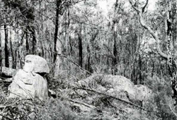 Forested slopes with outcropping granitic boulders |
| Deadhorse and Dargo land systems have similar parent rocks and climate but their soils are quite different. Deadhorse land system has more widespread. shallow, youthful. sandy soils. Deeper, more-developed soils frequently with duplex profiles do occur, though they are more common in Dargo land system. This difference may he due to more-intensive stripping of hillslopes by natural erosion processes in Deadhorse land system. Leaching has produced mildly- to moderately-acidic soils. The sandy topsoils are susceptible to sheet erosion and gullies tend to develop where the less-cohesive, gritty or sandy subsoils are disturbed. Open forest II with a sparse understorey dominates: open forest I occurs on drier crests. | ||
| CLIMATE Rainfall, mean (mm) Temperature, mean (°C) Seasonal growth limitations |
Annual 700 - 1200; lowest July or August (40 - 70), highest October (60 - 90) Annual 12 - 14; lowest July (8 - 10), highest February (19 - 21) Temperature <10°C (av.): May - September Rainfall < potential evapotranspiration: November - March |
| GEOLOGY Age, lithology |
Paleozoic granites. granodiorites, diorites and quartz-feldspar porphyries |
| PHYSIOGRAPHY Landscape Elevation range (m) Relative relief (m) Drainage pattern Drainage density (km/km2) |
Low rounded hills and undulating terrain 60 - 280 60 - 180 Dendritic 1.6 |
| PRESENT LAND USE |
|
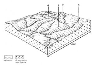 | 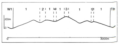 |
| LAND COMPONENT Percentage of land system Diagnostic features | 1 60 Gentle slopes sometimes with small sharp crests | 2 25 Short slopes and ridges with scattered granite boulders | 3 10 Major crests | 4 5 Valley flats |
| PHYSIOGRAPHY Slope %, typical and (range) Slope shape | 10, (0 - 20) Mainly convex | 15 - 20, (0 - 40) Convex | 5 - 10, (0 - 20) Convex | <5, (0 - 5) Straight |
| SOIL | ||||
| Parent material | Granite, granodiorite, diorite and quartz-feldspar porphyry | Light and medium textured alluvium | ||
| Description | Probably mozaic of shallow soils with dark loamy sand to sandy loam topsoil merging into brown or brownish yellow sand subsoil (probably most common) and moderately deep soils with dark sandy loam resting on mottled yellowish brown acid clay subsoil | Mostly undifferentiated grey to brown sand to sandy loam over stratified alluvium; may be gravelly | ||
| Classification | Earthy Sands, less commonly Yellow Podzolic Soils Uc5.23, Uc5.21, Uc4.11, Dy3.21, Dy3.61 | Alluvial Soils, Earthy Sands Uc1.21, Uc5.2-, Uc5.23 | ||
| Surface texture | Loamy sand to sandy loam | Sand to sandy loam | ||
| Surface consistence | Soft to slightly hard when dry, friable when moist | Soft to slightly hard when dry | ||
| Depth (m) | Shallow sandy soils: 0.3 - 0.6: duplex soils 0.6- 1.2 | >2.0 | ||
| Nutrient status | Sandy soils: low: duplex soils: moderate | Low to moderate | ||
| Available soil water capacity | Low | Low | ||
| Perviousness to water | Sandy soils: rapid: duplex soils: slow | Moderate to rapid | ||
| Drainage | Sandy soils: good: duplex soils: moderately good | Poor to good | ||
| Exposed stone (%) | <5 | <5 | ||
| Sampled profile number | - | - | ||
| NATIVE VEGETATION Structure of vegetation and characteristic species of dominant stratum (+ Predominant species) | Open forest II: E. globoidea, E. macrorhyncha or E. sieberi predominant with E. polyanthemos and/or E. cypellocarpa | Open forest I,11: E. globoidea, E. macrorhyncha or E. sieberi predominant with E. polyanthemos and/or E. cypellocarpa | Limited data — probably open forest II: E. ovata+, E. polyanthemos+ or E. bridgesiana+ occasionally with E. globoidea and/or E. cypellocarpa or E. radiata Rare remnants of closed forest II with Rapanea howittiana, climbers. ferns and epiphytes | |
Disturbance | Affected process and trend | Primary resultant deterioration | Casual activities | Primary off-site process | ||
Form | Susceptibility of components | Incidence with components | ||||
— reduction in leaf area, rooting depth and/or perenniality | Reduced transpiration, resulting in increased deep percolation and leaching | Nutrient loss | 1,2,3; low - moderate | Not determined | Removal of trees | Increased movement of water to groundwater: increased base-flow of streams |
| Increased overland flow and soil detachment | Sheet and rill erosion | 1,2,3; moderate - high | Uncommon | Clearing, logging, burning, road and dam building and other earth-moving activities, rabbit burrowing, trafficking by stock and vehicles. | Increased flash flows and sediment load. |
| Increased compaction With Reduced infiltration | Structure decline Sheet and rill erosion | 1,2,3.4: low 1.2.3: moderate - high | Uncommon Uncommon | Loss of organic matter from topsoil As for sheet and rill erosion above | - Increased flash flows |
| Increased soil break-up | Gully erosion Streambank | 1.2,3; moderate 4; moderate | Uncommon Uncommon | As for sheet and rill erosion above As for sheet and rill erosion above | Increased sediment load. Increased sediment load and turbidity |
| Comments: - | ||||||
© State of Victoria (Agriculture Victoria) 1996 - .

This work, Victorian Resources Online, is licensed under a Creative Commons Attribution 4.0 licence. You are free to re-use the work under that licence, on the condition that you credit the State of Victoria (Agriculture Victoria) as author, indicate if changes were made and comply with the other licence terms.
The licence does not apply to ‘branding’ or some ‘images or photographs’ that may be owned by third parties. We ask you to seek prior approval to use images using the VRO feedback form. Access to higher quality images can also be provided on request.
This page was last updated on .