
Diabase (Db)
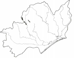 | Area: 30 sq. km (0.2%) This land system is small in area, occurring on Cambrian, ultrabasic, volcanic rocks with pockets of chert and paper shales. It is found over a range of elevations along the Barkly River and near Mount Wellington. Considerable outcrop of massive diabase is common and in some areas rock outcrop and large boulders would severely restrict the movement of tracked vehicles. The areas are quite variable in their lithology and ecology but the topography is generally mountainous with a ridge-and-ravine dissection pattern. Steep slopes and generally resistant rock have produced shallow, very stony soils of uniform loam to clay loam texture. Leaching under the high rainfall has been considerable and the soils are moderately acidic. The nutrient status however, is believed to be greater than that of similar soils derived from sedimentary rocks, for example those in Birregun land system. |
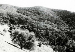 Steep slopes along the Licola-Jamieson Road remain mostly uncleared |
| Moisture availability tends to he greater on the upper slopes at higher elevations and on the protected lower slopes of ravines. These sites carry vigorous open forest III, often layered or shrubby. Open forest II, with species more typical of drier conditions, occurs on slopes at lower elevations. | ||
| CLIMATE Rainfall, mean (mm) Temperature, mean (°C) Seasonal growth limitations | Annual 800 - 1400; lowest July (40 - 70), highest October (60 - 90) Annual 8 - 12; lowest July (3 - 7), highest February (16 - 20) Temperature <10°C (av.): April - October Rainfall < potential evapotranspiration: December - February; occasional winter snow |
| GEOLOGY Age, lithology | Cambrian ultrabasic volcanic rocks and chert, paper shales and slates |
| PHYSIOGRAPHY Landscape Elevation range (m) Relative relief (m) Drainage pattern Drainage density (km/km2) | Variable mountainous terrain; generally ridge-and-ravine topography 400 - 1240 220 - 640 Dendritic 2.3 |
| PRESENT LAND USE | Uncleared: hardwood forestry (mainly second quality timber used mainly for general construction); apiculture; bush grazing of cattle |
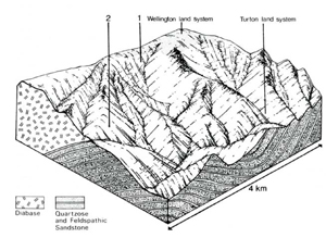 | 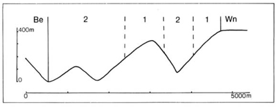 |
| LAND COMPONENT Percentage of land system Diagnostic features | 1 60 Slopes with humid forest | 2 40 Slopes with drier forest, generally at lower elevations |
| PHYSIOGRAPHY Slope %, typical and (range) Slope shape | 40 - 50. (30 - 80) Straight | 40 - 50, (30 - 80) Straight |
| SOIL | Variable; ultrabasic rock including diabase; shale, slate, chert and associated rock types | |
| Parent material | Dark coloured loam to clay loam merging into brown or reddish brown loam to clay loam. Generally shallow to very shallow with shallowest soils slopes; generally very stony not necessarily coincident with the steepest | |
| Description | Lithosolic Brown Earths, Lithosols Um5.52. Um1.41, Um 1.44 | |
| Classification | Loam to clay loam | |
| Surface texture | Soft to slightly hard | |
| Surface consistence | 0.2 -1.2 | |
| Depth (m) | Low to moderate | |
| Nutrient status | Moderate | |
| Available soil water capacity | Rapid | |
| Perviousness to water | Good | |
| Drainage | 50 - 70 (generally) | |
| Exposed stone (%) | - | |
| Sampled profile (No.) | ||
| NATIVE VEGETATION Structure of vegetation and characteristic species of dominant stratum (+ Predominant species) | Limited data — probably shrubby or layered open forest III of E. obliqua+, often with E. cypellocarpa; E. delegatensis+ presumed at higher elevations | Open forest II: E. goniocalyx+, E. macrorhyncha+ |
Disturbance | Affected process and trend | Primary resultant deterioration | Casual activities | Primary off-site process | ||
Form | Susceptibility of components | Incidence with components | ||||
— reduction in leaf area, rooting depth and/or perenniality — reduction in density of tree roots |
resulting in: a) increased deep percolation and leaching b) increased infiltration and regolith wetness Decreased root-binding |
Nutrient loss Soil creep Soil creep |
Not determined 1: moderate 2; low 1; moderate 2: low |
Not determined Not determined Not determined |
Removal of trees Accelerated by clearing of native vegetation Accelerated by clearing of native vegetation |
Increased movement of water to groundwater; increased base-flow of streams Increased sediment load Increased sediment load |
|
|
|
|
|
|
|
|
With Reduced infiltration |
Sheet and rill erosion |
1,2;moderate |
Not determined |
As for sheet and rill erosion above |
Increased flash flows |
|
|
|
|
|
|
|
| ||||||
© State of Victoria (Agriculture Victoria) 1996 - .

This work, Victorian Resources Online, is licensed under a Creative Commons Attribution 4.0 licence. You are free to re-use the work under that licence, on the condition that you credit the State of Victoria (Agriculture Victoria) as author, indicate if changes were made and comply with the other licence terms.
The licence does not apply to ‘branding’ or some ‘images or photographs’ that may be owned by third parties. We ask you to seek prior approval to use images using the VRO feedback form. Access to higher quality images can also be provided on request.
This page was last updated on .