
Clifton (Cn)
 | Area: 157 sq. km (0.8%) Clifton land system occurs on Tertiary fan deposits along the margin of the East Victorian Uplands, with the largest area being to the north of Lakes Entrance. Almost flat. plateau remnants and dissected, low plateaux, with closely-spaced, small spurs protruding into the main drainage corridors are characteristic. A clayey plinthite underlies the surface and it outcrops in the gullies and other dissected areas. The major difference from Salt Creek, Anderson 1 and 2 and Stockdale land systems is that parts of the original plateau surface are preserved. Although deep sands do occur, duplex soils appear to dominate. Under the moderate to high rainfall the soils tend to he leached and acidic. Gully erosion is more likely in those areas with dispersive subsoils. On the deep sands a hardpan, probably siliceous, was observed but pans of coffee-rock are also to be expected. The vegetation on the sands indicates that they arc underlain by clay and/or that the nutrient status is not as low as on other leached deep sands. Open forest II predominates and is often shrubby, particularly in drainage lines. | 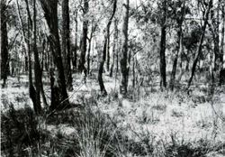 An almost flat plateau remnant, typical of this land system, with an open forest of Eucalyptus sideroxylon (red ironbark), E. polyanthemos (red box) and stringybark species. |
| CLIMATE Rainfall, mean (mm) Temperature, mean (°C) Seasonal growth limitations | Annual 700-1200; lowest July or August (40 - 70), highest October (60 - 90) Annual 12 - 14; lowest July (8 - 10), highest February (19 - 21) Temperature <10°C (av.): May - September Rainfall <potential evapotranspiration: November – March |
| GEOLOGY Age, lithology | Tertiary fan and colluvial apron deposits; unconsolidated gravels, sands, silts and clays (Sale Group) |
| PHYSIOGRAPHY Landscape Elevation range (m) Relative relief (m) Drainage pattern Drainage density (km/km2) | Dissected remnants of a Tertiary land surface 80 - 300 10 - 80 Dendritic 2.6 |
| PRESENT LAND USE | Mostly uncleared: hardwood forestry (sleepers, poles and minor products); apiculture; small areas set aside for nature conservation within Glenmaggie Flora and Fauna Reserve; bush grazing of cattle (very limited) Minor proportion cleared: grazing of cattle and sheep; softwood plantations |
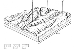 | 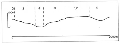 |
| LAND COMPONENT Percentage of land system Diagnostic features | 1 10 Almost flat plateau remnants with deep surface sands | 2 30 Almost flat plateau remnants with duplex soils | 3 45 Broken slopes and small closely spaced steep spurs; deep duplex soils | 4 15 Valley flats |
| PHYSIOGRAPHY Slope %, typical and (range) Slope shape | 2 - 5, (0 - 10) Straight | 2 - 5. (0 - 10) Straight | 10 - 15, (5 - 30) Convex but variable | 1. (0 - 5) Concave but variable |
| SOIL | ||||
| Parent material | Clay, silt, sand and gravel | Alluvium: mostly lighter textures | ||
| Description | Limited observations — deep greyish brown sand. may have hardpan at depth; may be gravelly | Sand to sandy loam topsoil resting abruptly on yellowish brown acidic blocky clay subsoil | Mainly undifferentiated brown sandy loam over mottled substrata, sometimes of heavier texture | |
Topsoil dark grey, subsoil strongly mottled | Topsoil brown or greyish brown, sometimes minor mottling in subsoil | |||
| Classification | Siliceous Sands and/or Podzols Uc5.13 | Yellow Podzolic Soils Dy3.21. Dy3.41, Dy3.42 | Yellow and Brown Podzolic Soils Dy2.41. Dy3.21, Db1.21 | Alluvial Soils Uc1.41, Uc1.43, Uc5.23 |
| Surface texture | Sand | Sand to sandy loam, sometimes gravelly | Sandy loam | |
| Surface consistence | Soft when dry | Mainly soft to slightly hard when dry | Very friable when moist | |
| Depth (m) | >2.0 | >2.0 | >2.0 | |
| Nutrient status | Low | Low to moderate | Low to moderate | |
| Available soil water capacity | Low | Low | Moderate | |
| Perviousness to water | Rapid | Moderate to rapid | Rapid | |
| Drainage | Good | Somewhat poor | Moderately good | Somewhat poor to good |
| Exposed stone (%) | 0 | 0 | 0 | 0 |
| Sampled profile number | - | 48 | - | - |
| NATIVE VEGETATION Structure of vegetation and characteristic species of dominant stratum (+ Predominant species) | Limited data — probably mainly open forest II of mixed species including E. sieberi. E. globoidea, E. muellerana | Open forest II, Mixed forests with E. sieberi or E. globoidea predominant; E. cypellocarpa, F. sideroxylon. E. polyanthemos. L. bridgesiana and E. macrorhyncha associated | Often shrubby: Mixed forests with E. globoidea predominant; E. cypellocarpa, E. bosistoana. E. polyanthemos associated | Shrubby open forest II or shrubby woodland II: Composition variable — E. polyanthemos or E. ovata usually predominant; E. obliqua sometimes associated. Melaleuca spp. and/or Leptospermum spp. dominate the understorey |
Disturbance | Affected process and trend | Primary resultant deterioration | Casual activities | Primary off-site process | ||
Form | Susceptibility of components | Incidence with components | ||||
— reduction in leaf area, rooting depth and/or perenniality | Reduced transpiration, resulting in increased deep percolation and leaching | Nutrient loss | 1; high 2.3; low | Not determined | Removal of trees | Increased movement of water to groundwater: increased base-flow of streams |
| Increased overland flow and soil detachment | Sheet and rill erosion | 1; very low 2: low 3: moderate | Uncommon; local occurrence on cleared land | Clearing, overgrazing, road and dam building and other earth-moving activities, rabbit burrowing, trafficking by stock and vehicles. | Increased flash flows and sediment load. |
| Increased compaction With reduced infiltration | Structure decline Sheet and rill erosion | 1,2,3,4; low 1; very low 2; low 3; moderate | Uncommon; local occurrence on cleared land Uncommon: local occurrence on cleared land | Increased trafficking cultivation, overgrazing, export of organic matter As for sheet and rill erosion above | - Increased flash flows |
| Increased soil break-up | Gully erosion | 1: very low 2: low 3: moderate | Uncommon; local occurrence | As for sheet and rill erosion above | Increased sediment load. |
| ||||||
© State of Victoria (Agriculture Victoria) 1996 - .

This work, Victorian Resources Online, is licensed under a Creative Commons Attribution 4.0 licence. You are free to re-use the work under that licence, on the condition that you credit the State of Victoria (Agriculture Victoria) as author, indicate if changes were made and comply with the other licence terms.
The licence does not apply to ‘branding’ or some ‘images or photographs’ that may be owned by third parties. We ask you to seek prior approval to use images using the VRO feedback form. Access to higher quality images can also be provided on request.
This page was last updated on .