
Clifford (Cd)
 | Area: 185 sq. km (1.0%) All cliffs and precipitous mountain slopes are included in Clifford land system, except those which are densely forested. The latter are included in Kirchubel land system. Slopes are steeper than for most of the ridge-and-ravine terrain and are sometimes almost vertical. Inclined stratigraphic sequences of hard and soft rocks are characteristic and prominent outcrops of resistant rock are common. Many of the precipitous slopes have been caused by erosion of softer materials underlying more resistant strata. Major rivers flow through some of the rocky ravines. Lithology and degree of humidity vary considerably within the land system. Steep slopes, water-shedding, rock outcrop and a high proportion of bare ground results in very high, natural erosion rates. At the same time, the high proportion of resistant rocks leads to a slow rate of soil formation. As a result the soils, where they occur, are very shallow, stony and well leached. Any disturbances can only cause an increase in the already high natural erosion rates. The vegetation is often sparse. Open forest or woodland I or II predominate, with grasslands and shrublands on rockier slopes or at higher elevations. | 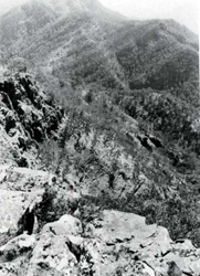 Stratigraphic sequences of hard and soft rock are apparent on the steep slopes and rocky cliffs overlooking Bryce's Gorge. |
| CLIMATE Rainfall, mean (mm) Seasonal growth limitations |
Annual 8 - 12; lowest July (3 - 7), highest February (16 - 20) Temperature <10°C (av.): April - October Rainfall < potential evapotranspiration: February; frequent winter snow |
| GEOLOGY Age, lithology |
Variable; mainly Palaeozoic sandstones, siltstones. mudstones, conglomerates and Devonian rhyolites and rhyodacites |
| PHYSIOGRAPHY Landscape Elevation range (m) Relative relief (m) Drainage pattern Drainage density (km/km2) |
Very steep and precipitous mountain slopes and cliffs 200 - 1640 200 - 680 Dendritic 1.2 |
| PRESENT LAND USE |
|
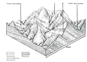 | 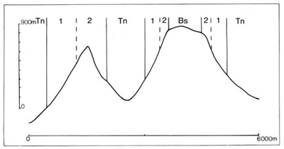 |
| LAND COMPONENT Percentage of land system Diagnostic features | 1 55 Very steep slopes | 2 45 Precipitous slopes and cliffs at higher elevations with prominently exposed rock strata |
| PHYSIOGRAPHY Slope %, typical and (range) Slope shape | 50 - 70, (40 - 100) Straight | Variable, (60 - vertical) Straight |
| SOIL | ||
| Parent material | Resistant sedimentary rock, such as quartzitic sandstone. interbedded with more weatherable siltstone and mudstone; rhyolite and rhyodacite | |
| Description | Dark loamy topsoil grading into brown or slightly reddish brown loam to clay loam subsoil: moderately to strongly acidic: very shallow and stony, rock outcrop common | |
| Classification | Lithosols Um1.43/Um5.51 | |
| Surface texture | Only loam observed | |
| Surface consistence | Probably slightly hard when dry, friable when moist | |
| Depth (m) | <0.4 | |
| Nutrient status | Low | |
| Available soil water capacity | Low | |
| Perviousness to water | Moderate | |
| Drainage | Good to excessive | |
| Exposed stone (%) | Probably50 - 100 | |
| Sampled profile number | - | |
| NATIVE VEGETATION Structure of vegetation and characteristic species of dominant stratum (+ Predominant species) | Open forest or woodland I, II: Species vary with exposure and elevation — E. pauciflora on higher more exposed sites grading into E. dives, often with E. rubida. Or into E. macrorhyncha with E. mannifera or E. goniocalyx,- F. polyanthemos sometimes associated. F. delegatensis occurs on most protected sites | Mainly grasslands of Poa spp., Danthonia spp. and Themeda australis with Leptorhynchos squamatus and Craspedia glauca: some heathlands including Crowea exalata, Brachyloma daphnoides and Leucopogon Worms. Trees, as for component I, often on structural ledges |
Disturbance | Affected process and trend | Primary resultant deterioration | Casual activities | Primary off-site process | ||
Form | Susceptibility of components | Incidence with components | ||||
— reduction in leaf area, rooting depth and/or perenniality — reduction in density of tree roots | Reduced transpiration, resulting in increased deep percolation. Decreased root-binding | Nutrient loss Soil creep | Not determined 1; low | Not determined Not determined | Removal of trees Accelerated by clearing of native vegetation | Increased movement of water to groundwater; increased base-flow of streams Increased sediment load |
| Increased overland flow and soil detachment | Sheet and rill erosion | 1.2; high | Not determined | Clearing, logging, burning, road building and other earth-moving activities | Increased flash flows and sediment load. |
| Increased compaction With reduced infiltration | Structure decline Sheet and rill erosion | 1; low 1.2; high | Not determined Not determined | Loss of organic matter from topsoil As for sheet and rill erosion above | - Increased flash flows |
| Increased soil break-up | Gully erosion | I: high | Not determined | As for sheet and rill erosion above | Increased sediment load. |
| Comments: No observations of deterioration | ||||||
© State of Victoria (Agriculture Victoria) 1996 - .

This work, Victorian Resources Online, is licensed under a Creative Commons Attribution 4.0 licence. You are free to re-use the work under that licence, on the condition that you credit the State of Victoria (Agriculture Victoria) as author, indicate if changes were made and comply with the other licence terms.
The licence does not apply to ‘branding’ or some ‘images or photographs’ that may be owned by third parties. We ask you to seek prior approval to use images using the VRO feedback form. Access to higher quality images can also be provided on request.
This page was last updated on .