
Cascade (Cc)
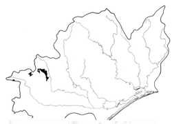 | Area: 71 sq. km (0.4%) Cascade land system occurs below the subalpine tract. mostly flanking the Baw Baw Plateau, and is traversed by many drainage lines. Although the gradient is moderate, the terrain is hilly with short, steep slopes, rocky crests, and some bogs. Dissection is based upon jointing pattern in the granodiorite, with major streams incised in joints normal to the contour. A cool climate, high rainfall and a parent rock that weathers easily have produced deep soils, even on steep slopes. Weathering of iron-hearing minerals, combined with leaching of bases and a high production of organic matter by the vegetation, have resulted in moderately acidic, well-aggregated soils, with a crumb or fine blocky structure in the upper horizons and more earthy fabric in the subsoil. The vegetation is mainly shrubby open forest III, with some closed forest II and III in narrow drainage floors and open forest II on rocky crests. |  Eucalyptus regnans (mountain ash) forest with an understorey of tree ferns characteristic of slopes at lower elevations. |
| CLIMATE Rainfall, mean (mm) Temperature, mean (°C) Seasonal growth limitations |
Annual L200 - 1800: lowest January or February (70 - 100), highest August or September (130 - L80) Annual 8 - I2; lowest July (3 - 7), highest February (16 - 20) Temperature <10°C (av.): April - October Rainfall < potential evapotranspiration: February; frequent winter snow |
| GEOLOGY Age, lithology |
Devonian; Baw Baw Granodiorite |
| PHYSIOGRAPHY Landscape Elevation range (m) Relative relief (m) Drainage pattern Drainage density (km/km2) |
Moderately sloping flanks below the Baw Baw Plateau 560 - 1320 180 - 360 Rectangular 1.3 |
| PRESENT LAND USE |
|
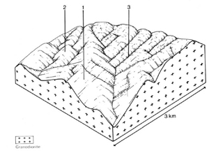 | 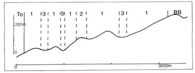 |
| LAND COMPONENT Percentage of land system Diagnostic features | 1 75 Slopes, mostly short and steep | 2 10 Crests often rocky | 15 Narrow drainage depressions. often with small peat bogs |
| PHYSIOGRAPHY Slope %, typical and (range) Slope shape | 25 - 30, (20 - 50) Straight to convex | <5, (0 - 10) Convex | <1. (0 - 5) Concave |
| SOIL | |||
| Parent material | Granodiorite | Alluvium and colluvium | |
| Description | Black sandy loam to sandy clay loam, merging into brown similarly textured or more clayey subsoil with weak structure; generally shallower in component 2 | Shallow sandy and gravelly undifferentiated soils; localised organic soils | |
| Classification | Brown Earths Uc6.11, Uc6.14, Gn2.11, Gn2.41 | Brown Earths Um7.11 | Alluvial Soils, Acid Peat Uc1. - .0 |
| Surface texture | Sandy loam to sandy clay | Sandy loam to sandy clay | Variable |
| Surface consistence | Soft | Soft | Soft |
| Depth (m) | >2.0 | >2.0 | >2.0 |
| Nutrient status | Moderate | Moderate | Moderate; low for peats |
| Available soil water capacity | Moderate | Moderate | Moderate |
| Perviousness to water | Rapid | Rapid | Rapid |
| Drainage | Good | Good | Somewhat poor; very poor for peats |
| Exposed stone (%) | 0 - 5 | 0 - 5 | 0 |
| Sampled profile number | - | - | - |
| NATIVE VEGETATION Structure of vegetation and characteristic species of dominant stratum (Predominant species) | Shrubby open forest Ill: Higher elevations — E. delegatensis+ with or without E. nitens; E. nitens+ Lower elevations — E. regnans+ with or without E. obliqua Closed forest II, III of Nothofagus cunninghamii sometimes on lower slopes | Limited data — probably mainly open forest II: E. delegatensis | Bogs principally with Richea continentis, Carex appressa and Sphagnum spp. Scattered N. cunninghamii and Leptospermum grandifolium on higher ground |
Disturbance | Affected process and trend | Primary resultant deterioration | Casual activities | Primary off-site process | ||
Form | Susceptibility of components | Incidence with components | ||||
— reduction in leaf area, rooting depth and/or perenniality |
|
|
|
|
|
|
|
|
|
2; low |
|
|
|
|
With reduced infiltration |
Sheet and rill erosion |
3; high 1; moderate 2; low |
Not determined |
from topsoil. As for sheet and rill erosion above |
Increased flash flows |
|
|
|
|
|
erosion above |
|
| ||||||
© State of Victoria (Agriculture Victoria) 1996 - .

This work, Victorian Resources Online, is licensed under a Creative Commons Attribution 4.0 licence. You are free to re-use the work under that licence, on the condition that you credit the State of Victoria (Agriculture Victoria) as author, indicate if changes were made and comply with the other licence terms.
The licence does not apply to ‘branding’ or some ‘images or photographs’ that may be owned by third parties. We ask you to seek prior approval to use images using the VRO feedback form. Access to higher quality images can also be provided on request.
This page was last updated on .