
Carrabungla (Ca)
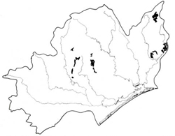 | Area: 169 sq. km (0.9%) This land system occurs mainly on a variety of acidic, volcanic rocks, including the Wellington Rhyolites and the Snowy River Volcanics. The terrain is mountainous with steep, rocky slopes and a ridge-and-ravine topography. In these respects the land is similar to Elizabeth land system, but Carrabungla occurs where it is much drier, mostly at lower elevations. Small levees and alluvial flats, similar to those in Walnut land system. occur occasionally along a few major streams, notably Wilkinson Creek. The shallow soils reflect a combination of dry climate, steep slopes and parent materials that are resistant to weathering. Leaching of bases has produced moderately-acidic soils. Surface soils have a crumb structure while the subsoils are often apedal. The vegetation is mainly open forest II, often shrubby with sparse ground cover. Forests with slightly denser understoreys occur where moisture supply is greater. due to altitude, aspect or protection by adjacent slopes. | 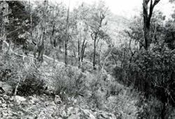 A steep rocky slope with drier vegetation and patches of bare earth and litter characteristic of Carrabungla land system. |
| CLIMATE Rainfall, mean (mm) Temperature, mean (°C) Seasonal growth limitations |
Annual 700) - 1200); lowest January or February (40 - 80), highest October (100) - 150) Annual 8 - 12; lowest July (3 - 7), highest February (16 - 20) Temperature <10°C (av.): May - September Rainfall < potential evapotranspiration: December – February |
| GEOLOGY Age, lithology | |
| PHYSIOGRAPHY Landscape Elevation range (m) Relative relief (m) Drainage pattern Drainage density (km/km2) |
Steep mountains with ridge-and-ravine topography 220 - 1000 140 - 600 Dendritic 1.4 |
| PRESENT LAND USE |
|
| 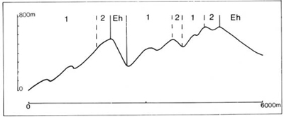 |
| LAND COMPONENT Percentage of land system Diagnostic features | 1 85 Slopes with very dry forest | 2 15 Slopes with more vigorous forest, mostly on protected upper slopes |
| PHYSIOGRAPHY Slope %, typical and (range) Slope shape | 30 - 40, (20 - 80) Straight but uneven | 30 - 40, (20 - 50) Straight |
| SOIL | ||
| Parent material | Mainly rhyolite and rhyodacite | Mainly rhyolite and rhyodacite |
| Description | Dark brown sandy loam to sandy clay loam grading into dark reddish brown or brown sandy clay loam or clay; generally stony. Somewhat shallow | Dark greyish brown to black loam to sandy clay loam grading into dark reddish brown or brown sandy clay loam or clay loam; generally stony, somewhat shallow |
| Classification | Brown Earths, Lithosols Um l.42, Um4.23; also Um5.51, Gn2.81, Gn3.51 | Brown Earths, Lithosols Um4.13. Um5.52. Uc6.14 |
| Surface texture | Sandy loam to sandy clay loam | Loam to sandy clay loam |
| Surface consistence | Soft to slightly hard when dry, friable when moist | Soft when dry, friable when moist |
| Depth (m) | 0.3 - 1.2 | 0.5 - 1.5 |
| Nutrient status | Low to moderate | Low to moderate |
| Available soil water capacity | Low to moderate | Moderate |
| Perviousness to water | Moderate | Rapid |
| Drainage | Good | Good |
| Exposed stone (%) | 10 - 80 | 0 - 20 |
| Sampled profile number | 12 | - |
| NATIVE VEGETATION Structure of vegetation and characteristic species of dominant stratum (+ Predominant species) | Open forest II, sometimes shrubby: Mixed forests with composition and predominant species variable (one of which usually predominant), E. mannifera, E. goniocalyx, elevations. E. pauciflora: Xanthorrhoea | Open forest II, III, often shrubby: including E. dives, E. sieberi, E. macrorhyncha. E. consideniana E. polyanthemos, E. rubida, E. baxteri, E. muellerana and, at higher australis occurs occasionally |
Disturbance | Affected process and trend | Primary resultant deterioration | Casual activities | Primary off-site process | ||
Form | Susceptibility of components | Incidence with components | ||||
— reduction in leaf area, rooting depth and/or perenniality |
|
| Not determined | Not determined | Removal of trees |
water to groundwater; increased base-flow of streams |
|
|
| 1.2; high | Not determined | Clearing, logging, burning, road building and other earth-moving activities |
and sediment load. |
|
With reduced infiltration |
Sheet and rill erosion | 12; low - moderate 1,2; high | Not determined Not determined | Loss of organic matter from topsoil As for sheet and rill erosion above |
Increased flash flows |
|
|
| 1.2; moderate | Not determined | As for sheet and rill erosion above |
|
| Comments: No observations of deterioration | ||||||
© State of Victoria (Agriculture Victoria) 1996 - .

This work, Victorian Resources Online, is licensed under a Creative Commons Attribution 4.0 licence. You are free to re-use the work under that licence, on the condition that you credit the State of Victoria (Agriculture Victoria) as author, indicate if changes were made and comply with the other licence terms.
The licence does not apply to ‘branding’ or some ‘images or photographs’ that may be owned by third parties. We ask you to seek prior approval to use images using the VRO feedback form. Access to higher quality images can also be provided on request.
This page was last updated on .