
Buln Buln (Bu)
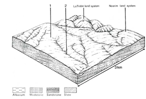
 | Area: 28 sq. km (0.1%) In the west of the study area near Buln Buln East, areas of Devonian and other Palaeozoic sediments, exposed by removal of Older Volcanics. have been mapped in Buln Buln land system. Areas still covered with basalt are in Neerim land system. In some areas, exposure of the Palaeozoic sediments occurs only in valley floors where drainage has incised the basalt. Landform consists of rounded hills and alluviated valleys very similar to those of Neerim land system. Mostly fine-textured. sedimentary rocks and their slightly-metamorphosed counterparts and a moderate to high rainfall produced deep soils with significant amounts of clay. The soils are generally leached and acidic, with lighter-textured topsoils overlying mottled, clayey subsoils. Some basaltic influence may occur locally where material from Neerim land system has been deposited. The remnant native vegetation is mainly open forest II. with a shrubby woodland I in drainage lines. Similar forests probably occurred in the areas that have now been cleared. | 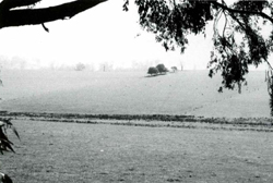 Characteristic low hills with relatively gentle slopes and rounded crests; sedges now grow in the cleared valley that probably once carried Eucalyptus ovata (swamp gum). |
| CLIMATE Rainfall, mean (mm) Temperature, mean (°C) Seasonal growth limitations | Annual 700-1200: lowest January or February (40 - 70). highest August or October (90 - 120) Annual 12 - 14; lowest July (8 - 10). highest February (19 - 21) Temperature <10°C (av.): May - September Rainfall < potential evapotranspiration: December – February |
| GEOLOGY Age, lithology | Devonian sandstones, mudstones, shales and slates (Centennial Beds and Coopers Creek Formation, also undifferentiated Tanjil Formation) |
| PHYSIOGRAPHY Landscape Elevation range (m) Relative relief (m) Drainage pattern Drainage density (km/km2) | Slopes, rounded hills and alluviated valley floors 80 - 260 40 - 100 Dendritic 1.6 |
| PRESENT LAND USE | Mostly cleared: grazing of beef and dairy cattle on improved pasture. Minor proportion uncleared: hardwood forestry (timber for general construction); apiculture |
 | 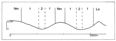 |
| LAND COMPONENT Percentage of land system Diagnostic features | 1 80 Slopes and rounded crests | 2 20 Waterlogged valley floors, often channelled |
| PHYSIOGRAPHY Slope %, typical and (range) Slope shape | 12 - 18, (0 - 30) Mainly convex | <2. (0 - 5) Straight |
| SOIL | ||
| Parent material | Mudstone, shale, sandstone and slate | Mainly fine-textured alluvium |
| Description | Limited observations — dark greyish brown often fine structured sandy loam to clay loam topsoil over mottled yellowish brown blocky structured clay subsoil | Limited observations — probably mainly moderately heavy textured topsoil over blocky strongly mottled yellowish brown clay subsoil: possibly slightly alkaline |
| Classification | Yellow Podzolic Soils or intergrades with Xanthozems Dy3.21, Gn4.81 | Possibly Wiesenboden - |
| Surface texture | Sandy loam to clay loam | Probably silty loam to clay loam |
| Surface consistence | Friable when moist | Friable when moist |
| Depth (m) | >2.0 | >2.0 |
| Nutrient status | Low to moderate | Low to moderate |
| Available soil water capacity | Moderate | Moderate |
| Perviousness to water | Slow to moderate | Slow to moderate |
| Drainage | Somewhat poor to good | Poor |
| Exposed stone (%) | 0 | 0 |
| Sampled profile number | - | - |
| NATIVE VEGETATION Structure of vegetation and characteristic species of dominant stratum (+ Predominant species) | Limited data — probably mainly open forest II with E. obliqua+: E. dives and/or E. cypellocarpa often associated | Limited data — probably mainly shrubby woodland I of E. ovata. Leptospermum juniperinum and Melaleuca squarrosa in the understorey |
Disturbance | Affected process and trend | Primary resultant deterioration | Casual activities | Primary off-site process | ||
Form | Susceptibility of components | Incidence with components | ||||
— reduction in leaf area, rooting depth and/or perenniality | Reduced transpiration, resulting in increased deep percolation and leaching | Nutrient loss | Not determined | Not determined | Removal of trees | Increased movement of water to groundwater: increased base-flow of streams |
| Increased overland flow and soil detachment | Sheet and rill erosion | 1; moderate | Uncommon; local occurrence mainly on cleared land | Clearing, cultivation, burning. overgrazing. road and dam building and other earth-moving activities, trafficking by stock and vehicles. | Increased flash flows and sediment load. |
| Increased compaction With reduced infiltration | Structure decline Sheet and rill erosion | 1; low - moderate 2: high 1. moderate | Uncommon Uncommon: local occurrence mainly on cleared land | Increased trafficking and cultivation, overgrazing, export of organic matter As for sheet and rill erosion above | - Increased flash flows |
| Increased soil break-up | Gully erosion | 1,2: low - moderate | Uncommon | As for sheet and rill erosion above | Increased sediment load. |
| Comments: - | ||||||
© State of Victoria (Agriculture Victoria) 1996 - .

This work, Victorian Resources Online, is licensed under a Creative Commons Attribution 4.0 licence. You are free to re-use the work under that licence, on the condition that you credit the State of Victoria (Agriculture Victoria) as author, indicate if changes were made and comply with the other licence terms.
The licence does not apply to ‘branding’ or some ‘images or photographs’ that may be owned by third parties. We ask you to seek prior approval to use images using the VRO feedback form. Access to higher quality images can also be provided on request.
This page was last updated on .