
Baldhead (Bd)
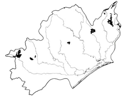 | Area: 229 sq. km (1.1%) Baldhead land system is restricted to the granites, granodiorites, gneissic-metamorphic and related coarsely-crystalline, plutonic rocks that occur mostly in the northern parts of the Eastern Victorian Uplands at relatively high elevation. Steep mountains with a ridge and-ravine pattern of dissection dominate, although some peaks are somewhat rounded. Small levees and alluvial flats, not extensive enough to map separately, occur occasionally along a few major streams, notably the La Trobe River. The area is similar in geology and topography to Blomford land system but is much more humid, with a corresponding difference in the vegetation and soils. A cool climate, and high rainfall with parent rocks that weather relatively easily, have produced moderately deep, soils, even on steep slopes. Soils are well-aggregated, particularly in the upper profile, but in some places subsoils are apedal and earthy. They are moderately acidic and permeable. Most of the area carries open forest III with a dense understorey which is layered on more protected aspects; lower, drier slopes carry open forest II. | 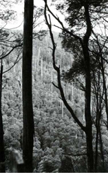 A steep slope with Eucalyptus delegatensis (alpine ash) forest. |
| CLIMATE Rainfall, mean (mm)Temperature, mean (°C) Seasonal growth limitations | Annual 900 - 1600; lowest January or February (50 - 90), highest August or September (120 - 180) Annual 8 - 12; lowest July (3 - 7), highest February (16 - 20) Temperature <10°C (av.): April - October Rainfall < potential evapotranspiration: February; frequent winter snow |
| GEOLOGY Age, lithology | Palaeozoic granites, granodiorites, gneissic metamorphics and related coarsely crystalline plutonic rocks |
| PHYSIOGRAPHY Landscape Elevation range (m) Relative relief (m) Drainage pattern Drainage density (km/km2) | Steep mountains with ridge-and-ravine topography 240 - 1360 100 - 680 Dendritic 0.8 |
| PRESENT LAND USE | Mostly uncleared: hardwood forestry (general construction and ash timber); some bush grazing of cattle; apiculture; small areas part of Baw Baw National Park. |
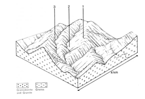 | 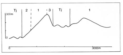 |
| LAND COMPONENT Percentage of land system Diagnostic features | 1 75 Slopes with humid forest (non ash species) | 2 15 Slopes with drier forest, usually at lower elevation | 3 10 Protected slopes with humid ash forest |
| PHYSIOGRAPHY Slope %, typical and (range) Slope shape | 30 - 40, (10 - 60) Straight | 25 - 35. (10 - 60) Straight | 30 - 40, (10 - 60) Straight |
| SOIL Parent Material | Granite. granodiorite and gneissic metamorphic rock | ||
| Description | Often stony, very dark greyish brown sandy loam to sandy clay loam merging into reddish brown sandy clay loam to sandy clay. Soils in component 2 usually shallower and stonier Gn2.11, Gn2.21, Um5.42, Um5.51 | Black to very dark greyish brown sandy loam to sandy clay loam merging into brown or reddish brown sandy loam to clay loam: often stony. Generally deeper than in components 1 and 2 | |
| Classification | Brown and Red Earths, Lithosols | Brown and Red Earths Um6.12, Um6.21, Um6.23, Gn2.11 | |
| Surface texture | Sandy loam to sandy clay loam | ||
| Surface consistence | Soft | ||
| Depth (m) | <2.0 | ||
| Nutrient status | Low to moderate | ||
| Available soil water capacity | Moderate | ||
| Perviousness to water | Rapid | ||
| Drainage | Good | ||
| Exposed stone (%) | Very variable: 0 - 75 | ||
| Sampled profile number | - | - | - |
| NATIVE VEGETATION Structure of vegetation and characteristic species of dominant stratum (+ Predominant species) | Shrubby open forest 11, III: Pure or mixed stands of E. dives (often predominant), E. cypellocarpa. E. obliqua, E. rubida. Minor occurrences of E. pauciflora at higher elevations in N.E. E. viminalis in valleys | Open forest II: E. sieberi generally predominant on mid- to upper slopes and crests: E. macrorhyncha, E. rubida. E. obliqua and E. cypellocarpa associated. Minor occurrences of F. pauciflora at higher elevations in N.E. | Open forest II. often layered: Higher elevations — E. delegatensis Lower elevations — E. regnans+ with or without E. obliqua or E. rubida |
Disturbance | Affected process and trend | Primary resultant deterioration | Causal activities | Primary off-site process | ||
Form | Susceptibility of components | Incidence within components | ||||
| Alteration of vegetation: — reduction in leaf area, rooting depth and/or perenniality — reduction in density of tree roots | Reduced transpiration, resulting in: a) increased deep percolation and leaching b) increased infiltration and regolith wetness Decreased root-binding | Nutrient loss Landslip and/or soil creep Soil creep | Not determined 1,2.3; low 12.3; moderate | Not determined Uncommon Uncommon | Removal of trees Usually after the removal of trees from steeper land Accelerated by clearing of trees | Increased movement of water to groundwater: increased base-flow of streams Increased sediment load Increased sediment load |
| Increased exposure of surface soil | Increased overland flow and soil detachment | Sheet and rill erosion | 1,2,3; moderate | Uncommon | Clearing, logging, burning, overgrazing, road and dam building and other earth-moving activities, rabbit burrowing, trafficking by stock and vehicles. | Increased flash flows and sediment load. |
| Increased physical pressure on soil | Increased compaction with reduced infiltration | Structure decline Sheet and rill erosion | 1,3; moderate - high 2; low 1.2,3: moderate | Uncommon Uncommon | Increased trafficking and cultivation, overgrazing, export of organic matter As for sheet and rill erosion above | - Increased flash flows |
| Increased soil disruption | Increased soil break-up | Gully erosion | 1,2.3: moderate | Uncommon | As for sheet and rill erosion above | Increased sediment load. |
| Comments: Good growing conditions generally result in quick regeneration of vegetative cover except on exposed sites at high elevation. | ||||||
© State of Victoria (Agriculture Victoria) 1996 - .

This work, Victorian Resources Online, is licensed under a Creative Commons Attribution 4.0 licence. You are free to re-use the work under that licence, on the condition that you credit the State of Victoria (Agriculture Victoria) as author, indicate if changes were made and comply with the other licence terms.
The licence does not apply to ‘branding’ or some ‘images or photographs’ that may be owned by third parties. We ask you to seek prior approval to use images using the VRO feedback form. Access to higher quality images can also be provided on request.
This page was last updated on .