
Booran 2 (B2)
 | Area: 3 sq. km (-%) Wave action on Lake Wellington has deposited sand on the eastern shore. A low-angle beach has formed there with a beach ridge. now partly reworked by wind into a low, discontinuous, frontal dune and a higher, continuous, rear dune. The rear dune tends to be about 3 times higher than the front dune, but it does not appear to exceed 10 m in height above lake level. To the south of these parallel dunes, near the lake outlet, is a series of relict beach ridges and recurved spits. The swale between the parallel dunes is mostly narrower and drier than the swales between the beach ridges and spits. The area is mapped in Booran 2 land system. In contrast to Booran 1 land system. this was formed in a freshwater environment and is more stable. | 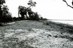 The low foredune with Banksia serrata (saw banksia) on the eastern shore of Lake Wellington. |
| The soils have formed on sands and the reaction is generally slightly acidic to neutral. The dominant well-drained, sandy soils have accumulated a little surface organic matter giving a slight darkening of the topsoil. This appears to he a little more prominent on the beach ridges than on the dunes. The soils are loose, apedal and of low fertility and water-holding capacity. Consequently, they are susceptible to wind erosion and leaching of nutrients. Old blowouts are common in the dunes. The soil of the dry, interdune swale is very similar to that of the dunes. In the wet swales between the beach ridges the situation appears to he very different. Here, shallow peaty topsoils and subsoils of silty and clayey textures have developed. Undifferentiated sands occur on the beach. The native vegetation is mostly grassy open woodland I or II with closed scrub in wetter swales in the south. | ||
| CLIMATE Rainfall, mean (mm) Temperature, mean (°C) Seasonal growth limitations |
Annual 500 - 800: lowest January (30 - 50), highest October (40 - 70) Annual 14: lowest July (10). highest February (19) Temperature <10°C (av.): July Rainfall < potential evapotranspiration: November – March |
| GEOLOGY Age, lithology |
Holocene lacustrine sand deposits |
| PHYSIOGRAPHY Landscape Elevation range (m) Relative relief (m) Drainage pattern Drainage density (km/km2) |
Beaches, coastal dunes and beach ridges 0 - 17 0 - 10 Nil 0 |
| PRESENT LAND USE |
Minor proportion cleared: grazing of beef cattle and sheep on native and improved pastures |
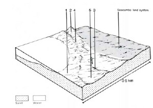 | 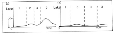 |
| LAND COMPONENT Percentage of land system Diagnostic features | 1 40 Beach | 2 30 Low foredune and higher rear dune | 3 20 Beach ridges and recurved spits | 4 5 Interdune swales (dry) | 5 5 Swales between beach ridges and spits (wet) |
| PHYSIOGRAPHY Slope %, typical and (range) Slope shape | 3-5,(2-7) Straight | 12-16,(10-25) Straight (front): concave (rear) | 3-5,(0-8) Convex, concave | <1,(0-2) Concave | <l.(0-2) Concave |
| SOIL | |||||
| Parent material | Wind-sorted sands of lacustrine origin, probably non-calcareous | ||||
| Description | Undifferentiated, relatively fine-grained sand | Greyish brown to brown loose sand grading into yellowish brown to brownish yellow sand at depth, slightly acid throughout | Very dark grey to dark greyish brown very friable loamy sand grading into brown to light grey sand subsoil, often neutral | Soils as in component 2 | Single observation — black peaty topsoil over grey and yellowish brown mottled, variable textured, alkaline subsoil |
| Classification | Alluvial Soils Uc1.21 | Siliceous Sands (pale) Uc1.21 | Alluvial Soils, Siliceous Sands Uc1.41, Uc1.21 | Siliceous Sands (pale) Uc1.21 | Humic Gleys Um1.41/O |
| Surface texture | Sand | Sand | Sand | Sand | Peaty loam |
| Surface consistence | Loose when dry | Loose when dry | Very friable when moist | Loose when dry | Friable when moist |
| Depth (m) | >2.0 | >2.0 | >2.0 | >2.0 | >2.0 |
| Nutrient status | Very low | Very low | Low | Very low | Low |
| Available soil water capacity | Very low | Very low | Low | Very low | High |
| Perviousness to water | Very rapid | Very rapid | Rapid | Very rapid | Rapid |
| Drainage | Poor (high water table) | Good to excessive | Good | Good to excessive | Very poor |
| Exposed stone (%) | 0 | 0 | 0 | 0 | 0 |
| Sampled profile number | - | - | - | - | - |
| NATIVE VEGETATION Structure of vegetation and characteristic species of dominant stratum (+ Predominant species) | Zoysia macrantha, sometimes with Pteridium esculentum growing higher up the beach | Grassy open woodland I of Banksia integrifolia+ (on deeper sands — mostly dunes in the north) Grassy open woodland I or II of E. tereticornis+ with or without Banksia integrifolia(on drier spits. beach ridges and swales and lower dunes) Melaleuca ericifolia dominates understorey on wetter beach ridges and spits and may form closed scrub in wet swales | |||
Disturbance | Affected process and trend | Primary resultant deterioration | Casual activities | Primary off-site process | ||
Form | Susceptibility of components | Incidence with components | ||||
— reduction in leaf area, rooting depth and/or perenniality |
|
|
2.3; high 4; moderate - high 5; low |
|
|
|
|
|
|
3; moderate 4; low |
|
|
|
|
|
|
4; low 5: moderate |
|
|
|
|
|
|
4; low 5; moderate |
|
|
|
© State of Victoria (Agriculture Victoria) 1996 - .

This work, Victorian Resources Online, is licensed under a Creative Commons Attribution 4.0 licence. You are free to re-use the work under that licence, on the condition that you credit the State of Victoria (Agriculture Victoria) as author, indicate if changes were made and comply with the other licence terms.
The licence does not apply to ‘branding’ or some ‘images or photographs’ that may be owned by third parties. We ask you to seek prior approval to use images using the VRO feedback form. Access to higher quality images can also be provided on request.
This page was last updated on .