
Booran 1 (B1)
 | Area: 23 sq. km (0.1%) This land system occurs on the modern outer barrier along the coastline and consists of the Ninety Mile Beach and associated berms and a narrow coastal dune system; all of Holocene age. The dune system is variable in form. It is composed of an almost continuous, linear, young foredune, sometimes plastered against an older dune field which may be almost completely buried by the younger foredune. Where the older dunes are higher than the foredune, the old dunes have an irregular shape, probably due to many past breaches by the wind. Elsewhere, the older dune field consists of a series of closely spaced, low ridges, parallel to, and immediately behind, the foredune. The modern barrier system has been built up of highly-calcareous marine sands. The soils increase in age with distance from the foredune and tend to become more leached and to have decreased lime content. Lime is not found in the upper two metres of soil in the fourth and older dunes. However the regular progression is upset where there is a major difference in the age of adjacent dunes. Here, highly-calcareous soils may abut non-calcareous soils. | 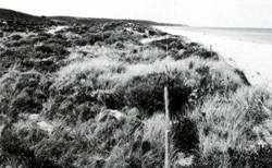 Beach and foredune of Booran 1 land system |
| Booran 1 land system is intrinsically unstable, with youthful, often mobile, unconsolidated materials and droughty soils not conducive to plant growth. It is highly susceptible to wind erosion and to loss of nutrients by leaching. Lime content affects the composition of the native vegetation. The largely unconsolidated beach and berm carry open grassland near the dunes. This changes to an increasingly greater cover of low shrubland up the seaward face of the foredune. On the crest and inland slope of the foredune and on any succeeding rear dunes with calcareous sands a closed scrub provides complete cover. On the rear dunes with non-calcareous sands, this is replaced by ferny open woodland I. | ||
| CLIMATE Rainfall, mean (mm) Temperature, mean (°C) Seasonal growth limitations |
Annual 500 - 800; lowest January (30 - 50). highest October (40 - 70) Annual 14; lowest July (10), highest February (19) Temperature <10°C (av.): No months Rainfall < potential evapotranspiration: November – March |
| GEOLOGY Age, lithology |
Holocene marine sands in littoral and coastal zones |
| PHYSIOGRAPHY Landscape Elevation range (m) Relative relief (m) Drainage pattern Drainage density (km/km2) |
Beaches. berms and coastal dunes of varying ages 0 - 20 0 - 15 Nil 0 |
| PRESENT LAND USE |
Minor proportion cleared: residential use |
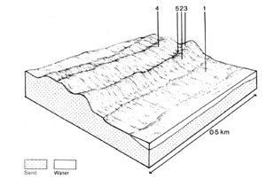 | 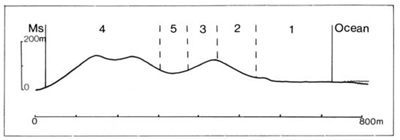 |
| LAND COMPONENT Percentage of land system Diagnostic features | 1 30 Beach and berm | 2 15 Young foredune – seaward facing slope | 3 15 Young foredune – landward facing slope and crest | 4 30 Older dunes with variable morphology | 5 10 Swales |
| PHYSIOGRAPHY Slope %, typical and (range) Slope shape | 1 - 5, (-) Variable | 30 - 60. (20 - 70) Straight | 20 - 40. (15 - 50) Straight | 10 - 25. (-) Straight | 0 - 10. (-) Concave |
| SOIL | |||||
| Parent material | Wind-sorted sand containing shell fragments of marine origin | ||||
| Description | Pale brown or yellowish calcareous sands; uniform texture except for darkening by organic matter in the topsoil | No observations — probably mainly pale sand with some organic matter in the topsoil. All or part of the original calcareous material lost from topsoil; massive calcareous concretions sometimes at depth | |||
| Classification | Calcareous Sands Uc1.11 | Siliceous Sands; probably Calcareous Sands Uc1.1- Uc1.2- | |||
| Surface texture | Sand | Sand | |||
| Surface consistence | Loose | Loose | |||
| Depth (m) | <2.0 | <2.0 | |||
| Nutrient status | Very low to low | Very low | |||
| Available soil water capacity | Very low to low | Very low to low | |||
| Perviousness to water | Very rapid | Very rapid | |||
| Drainage | Somewhat excessive | Somewhat excessive | |||
| Exposed stone (%) | 0 | 0 | |||
| Sampled profile number | - | - | 1 | - | |
| NATIVE VEGETATION Structure of vegetation and characteristic species of dominant stratum (+ Predominant species) | Open grassland: Spinifex hirsutus+ | Low shrubland: Acacia longifolia+ | Closed scrub: Leptospermum laevigatum+ | Closed scrub of Leptospermum laevigatum+ on calcareous rear dunes Open ferny woodland I with Banksia integrifolia+ and Pteridium esculentum on non-calcareous sands; E. vim malts var. racemosa occasionally on non-calcareous sands near Golden Beach | Closed scrub of Leptospermum laevigatum on calcareous sands Ferny open woodland I of B. integrifolia on non- calcareous sands |
Disturbance | Affected process and trend | Primary resultant deterioration | Casual activities | Primary off-site process | ||
Form | Susceptibility of components | Incidence with components | ||||
— reduction in leaf area, rooting depth and/or perenniality |
|
| 1: moderate 2,3.4; high 5: moderate - high | Not determined | Removal of trees |
|
|
|
| 1; high - very high 2; very high 3: moderate - very high 4; moderate - high 5; low | Common | Clearing, burning, construction activities (particularly tracks and road hatters), trafficking by humans and vehicles. |
|
|
|
| 12.3,4: very low 5: low | Not determined | Increased trafficking export of organic matter |
|
|
|
| As for wind erosion above | Common | As for sheet and rill erosion above |
|
| Comments: Regeneration of vegetative cover is difficult and restoration expensive because of dry. low-fertility soils. The problem is compounded in components 12, and 3 (crests) by strong winds. moving sand and salt spray. | ||||||
© State of Victoria (Agriculture Victoria) 1996 - .

This work, Victorian Resources Online, is licensed under a Creative Commons Attribution 4.0 licence. You are free to re-use the work under that licence, on the condition that you credit the State of Victoria (Agriculture Victoria) as author, indicate if changes were made and comply with the other licence terms.
The licence does not apply to ‘branding’ or some ‘images or photographs’ that may be owned by third parties. We ask you to seek prior approval to use images using the VRO feedback form. Access to higher quality images can also be provided on request.
This page was last updated on .