
Anderson 2 (A2)
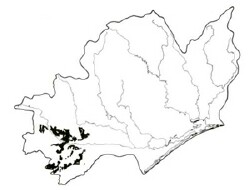 | Area: 392 sq. km (1.9%) In contrast to Anderson 1, the Anderson 2 land system occurs close to the margins of both the East Victorian Uplands and South Victorian Uplands on the Tertiary fan deposits which, compared with most of the lowlands, are deeply dissected. This dissection is due to the higher than usual elevation and steeper slopes of the deposits, and the coarse and relatively unconsolidated materials. Anderson 2 land system has rounded hills with moderate slopes and a broad dissection pattern. Anderson 1, Stockdale and Salt Creek land systems also occur on unconsolidated sediments with similar topography; however, the latter occur in a drier climate further to the east. Also Stockdale has sandier sediments and Salt Creek has E. tereticornis forests. | 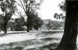 Steeper open slopes with Eucalyptus obliqua (messmate stringybark) typical of component 2. Steeper open slopes with Eucalyptus obliqua (messmate stringybark) typical of component 2. |
| The soil parent materials vary over short distances; dominantly silty or clayey, sometimes sandy. Yellowish brown, mottled, duplex soils are typical, but there is some variation within this group, for example, subsoil reaction varies from acidic to slightly alkaline. Where sandy, rather deep horizons overlie clays, iron cementation may occur at the interface of sand and clay. Podzols with coffee-rock occur on the small areas of deep sands, mainly in component 2. The sandy topsoils of duplex profiles are particularly susceptible to sheet erosion while the neutral to alkaline dispersive subsoils are susceptible to gully erosion. The deeper, sandy horizons present little resistance to leaching. The native vegetation that remains is mainly open forest II or III, occasionally shrubby. Similar forests probably covered most of the land system prior to clearing. | ||
| CLIMATE Rainfall, mean (mm) Temperature, mean (°C) Seasonal growth limitations | Annual 700 - 1200; lowest January (40 - 70), highest October (70 - 100) Annual 12 - 14; lowest July (8 - 10), highest February (19 - 21) Temperature <10°C (av.): June - August Rainfall < potential evapotranspiration: November – March |
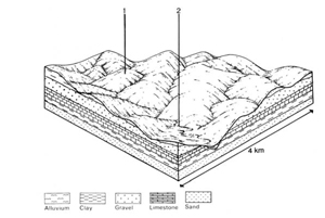
| GEOLOGY Age, lithology | Tertiary fan and colluvial apron deposits; gravels, sands, silts and clays |
| PHYSIOGRAPHY Landscape Elevation range (m) Relative relief (m) Drainage pattern Drainage density (km/km2) | Dissected relict coalescing fans marginal to the uplands 40 - 380 40 - 140 Dendritic 1.2 |
| PRESENT LAND USE | Mostly cleared: grazing of dairy and beef cattle and sheep on improved pastures; some softwood plantations Minor proportion uncleared: hardwood forestry (minor timber products); small areas in Morwell National Park |
 | 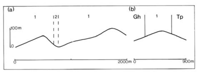 |
| LAND COMPONENT Percentage of land system Diagnostic features | 1 95 Crests and uneven, gentle to moderate slopes, occasionally steep | 2 5 Valley flats |
| PHYSIOGRAPHY Slope %, typical and (range) Slope shape | 7 - 15, (0 - 40) Variable | 2, (0 - 5) Straight |
| SOIL Parent material | Very variable: sand, clay or gravel | Variable alluvial material |
| Description | Dark sandy loam to sandy clay loam topsoil grading into pale subsurface soil of similar texture, generally abruptly overlying brown to yellowish brown mottled clay subsoil; silica cementation common in the subsurface. Minor areas of deep sand with brown, variably cemented rock at depth, locally overlying clay. | No observations – vary with parent materials; probably mainly medium to heavy textured and greyish brown with mottles; possibly sometimes with deep sandy topsoil. |
| Classification | Mostly Yellow Podzolic Soils, Soloths and Solodic Soils; some Yellow Earths and Podzols Mainly Dy3.42; some Gn3.85 and Uc2.32, Uc2.34, Uc4.22, Uc4.32 | Humic Gleys likely |
| Surface texture | Mainly sandy loam to sandy clay loam; sometimes sand | - |
| Surface consistence | Slightly hard to hard when dry, but soft or loose if very sandy | - |
| Depth (m) | >2.0 | - |
| Nutrient status | Low, very low for sands | >2.0 |
| Available soil water capacity | Generally moderate; very low for sands | Probably low |
| Perviousness to water | Mostly slow; very rapid for deep sands | Variable |
| Drainage | Mostly somewhat poor; somewhat excessive for deep sands | Variable |
| Exposed stone (%) | 0 | 0 |
| Sampled profile number | 47 | - |
| NATIVE VEGETATION Structure of vegetation and characteristic species of dominant stratum (+ Predominant species) | Open forest II, III: Composition variable — usually one or more of E. obliqua, E. bridgesiana, E. consideniana and E. radiata predominant. E. ovata (on poorly drained sites), E. sieberi and E. cephalocarpa associated | Open forest II or III: Variable composition including E. cypellocarpa+, E. viminalis+, E. obliqua and E. radiata |
Disturbance | Affected process and trend | Primary resultant deterioration | Causal activities | Primary off-site process | ||
| Form | Susceptibility of components | Incidence within components | ||||
| Alteration of vegetation: — reduction in leaf area, rooting depth and/or perenniality | Reduced transpiration, resulting in: a) increased deep percolation and leaching b) increased infiltration and regolith wetness | Nutrient loss Landslip and/or soil creep | 1; low, but high in areas of deep sand 1; low | Not determined Uncommon | Removal of trees Usually after the removal of trees from steeper land | Increased movement of water to groundwater; increased base-flow of streams Increased sediment load |
| Increased exposure of surface soil | Increased overland flow and soil detachment | Sheet and rill erosion | 1; moderate - high | Common | Clearing. Logging, burning, overgrazing, road and dam building and other earth-moving activities, rabbit burrowing, trafficking by stock and vehicles. | Increased flash flows and sediment load. |
| Increased physical pressure on soil | Increased compaction with reduced infiltration | Structure decline Sheet and rill erosion | 1; low 2; moderate - high 1; moderate - high | Uncommon Common | Increased trafficking and cultivation, overgrazing, export of organic matter As for sheet and rill erosion above | - Increased flash flows |
| Increased soil disruption | Increased soil break-up Increased loosening of sand | Gully erosion Wind erosion | 1,2; moderate - high 1; moderate on sandy soils | Local occurrence Uncommon | As for sheet and rill erosion above. Trafficking, overgrazing, rabbit burrowing, cultivating, earthmoving activities. | Increased sediment load. Encroachment by sand. |
| Comments: - | ||||||
© State of Victoria (Agriculture Victoria) 1996 - .

This work, Victorian Resources Online, is licensed under a Creative Commons Attribution 4.0 licence. You are free to re-use the work under that licence, on the condition that you credit the State of Victoria (Agriculture Victoria) as author, indicate if changes were made and comply with the other licence terms.
The licence does not apply to ‘branding’ or some ‘images or photographs’ that may be owned by third parties. We ask you to seek prior approval to use images using the VRO feedback form. Access to higher quality images can also be provided on request.
This page was last updated on .