
Anderson 1 (A1)
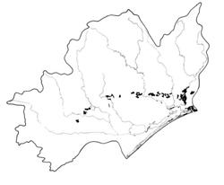 | Area: 176 sq. km (0.9%) Anderson 1 land system occurs where coarse, weakly-consolidated, Tertiary, fan deposits have suffered relatively deep dissection close to the margins of the East Victorian Uplands. Dissection has produced rounded hills with moderate slopes and a broad drainage pattern. Similar terrain on unconsolidated sediments is also found in Anderson 2, Stockdale and Salt Creek land systems. However, Anderson 2 is moister and thus has vegetative differences. Stockdale is notably sandier and Salt Creek has predominantly E. tereticornis forests. Boundaries between Anderson 1 and Stockdale land systems are tentative only. | 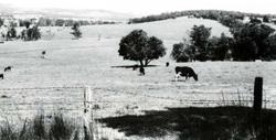 Gentle slopes now cleared and used for grazing |
| The dominant soil parent materials vary over short distances from sandy, silty or clayey. In places the entire profile has developed in sand, often with a coffee-rock layer at depth. This layer may be replaced by ferruginous nodules when the sand is underlain by clay. In less sandy deposits, finely-structured, medium-textured uniform soils occur together with duplex soils having dark grey, sandy loams overlying yellowish brown acidic clays. Limestone-derived, brown loams and calcareous, duplex soils occur in minor areas. The sandy topsoils of duplex soils are susceptible to sheet erosion and the deeper sands to leaching. The neutral to alkaline dispersive clay subsoils are susceptible to gullying. The native vegetation, now largely removed, is mainly open forest II or III, occasionally shrubby, with closed forest II in a few sheltered drainage corridors. Similar forests probably covered most of the area prior to clearing. | ||
| |
| Annual 600 - 900; lowest July or August (30 - 50), highest October (50 - 80) |
| Annual 12 - 14; lowest July (8 - 10), highest February (19 - 21) |
| Temperature <10°C (av.): June - August Rainfall < potential evapotranspiration: November – March |
| |
| Tertiary fan and colluvial apron deposits; unconsolidated gravels, sands, silts and clays (Sale Group); minor marine limestones (Seaspray Group) |
| |
| Dissected relict coalescing fans marginal to the uplands |
| 0 – 220 |
| 40 – 140 |
| Dendritic |
| 1.2 |
| Mostly cleared: grazing of beef and dairy cattle on improved pasture; softwood plantations. Minor proportion uncleared: hardwood forestry (minor timber products): small area in Nyerimelang Park |
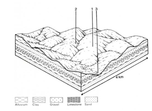 | 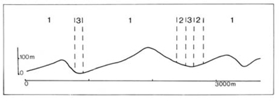 |
| LAND COMPONENT Percentage of land system Diagnostic features | 1 90 Uneven, gentle to moderate slopes, occasionally steep | 2 5 Steep valley slopes with exposed limestone (far east only) | 3 5 Valley flats |
| PHYSIOGRAPHY Slope %, typical and (range) Slope shape | 7 - 15, (0 - 30) Variable | 20- 30, (15 - 40) Straight to slightly concave | 2, (0 - 5) Straight |
| SOIL Parent material | Very variable; sand, silty clay or gravel | Limestone | Variable alluvial material |
| Description | Limited observations – variable; deep yellowish brown or brown sand over coffee rock or clay; yellowish brown fine structured sandy clay loam to clay loam; yellowish brown mottled duplex soil. | Limited observations – complex of shallow dark greyish brown loam to clay loam and deeper duplex soil with dark yellowish brown mottled calcareous clay subsoil. | No observations – soils vary with parent materials; probably mainly medium to heavy textured and greyish brown with mottles, possibly sometimes with deep sand topsoil. |
| Classification | Podzols, Earthy Sands, Yellow Earths, Solodic Soils Uc3.41, Uc5.22, Um5.52, Dy3.22 | Rendzinas, Red-brown Earths Um6.11, Db2.13 | Humic Gleys likely - |
| Surface texture | Often sandy | Often loamy | - |
| Surface consistence | Often very friable when moist | Friable to very firm when moist | - |
| Depth (m) | >2.0 | 0.3-1.2 | >2.0 |
| Nutrient status | Very low to low | Moderate to high | Probably low |
| Available soil water capacity | Low to moderate | Moderate | Variable |
| Perviousness to water | Variable; slow for clay subsoil | Slow to moderate | Variable |
| Drainage | Mostly good | Good | Very poor to poor |
| Exposed stone (%) | 0 | <10 | 0 |
| Sampled profile number | 10 | - | - |
| NATIVE VEGETATION Structure of vegetation and characteristic species of dominant stratum (+ Predominant species) | Open forest II, shrubby open forest III: E. globoidea+, E. cypellocarpa, often with E. polyanthemos and occasionally E. bosistoana: E. sieberi+ on upper slopes | Open forest 11. 111: Limited data — probably mainly E. hauerona. E. melliodora, E. cypellocarpa and E. elata | Limited data — probably mainly open forest II, III with E. cypellocarpa+ (observed), E. bridgesia+, E. viminalis (presumed) Occasionally closed forest II of Acmena smithii. climbers, ferns and epiphytes |
Disturbance | Affected process and trend | Primary resultant deterioration | Causal activities | Primary off-site process | ||
| Form | Susceptibility of components | Incidence within components | ||||
| Alteration of vegetation: — reduction in leaf area, rooting depth and/or perenniality | Reduced transpiration, resulting in: a) increased deep percolation and leaching b) increased infiltration and regolith wetness | Nutrient loss Landslip and/or soil creep | 1; low - high 2; low 1; low | Not determined Uncommon | Removal of trees Usually after the removal of trees from steeper land | Increased movement of water to groundwater; increased base-flow of streams Increased sediment load |
| Increased exposure of surface soil | Increased overland flow and soil detachment | Sheet and rill erosion | 12; moderate - high 3; low | Common | Clearing, logging, burning, overgrazing, road and dam building and other earth-moving activities, rabbit burrowing, trafficking by stock and vehicles. | Increased flash flows and sediment load. |
| Increased physical pressure on soil | Increased compaction with reduced infiltration | Structure decline Sheet and rill erosion | 1; low 2,3; moderate - high 1,2; moderate - high 3; low | Uncommon Common | Increased trafficking and cultivation, overgrazing, export of organic matter As for sheet and rill erosion above | - Increased flash flows |
| Increased soil disruption | Increased soil break-up Increased loosening of sand | Gully erosion Wind erosion | 1,2,3; moderate - high 1; moderate on sandy topsoils | Uncommon, but local occurrences. Uncommon; local occurrences on exposed cleared sites. | As for sheet and rill erosion above. Trafficking, overgrazing, rabbit burrowing, cultivating, earthmoving activities. | Increased sediment load. Encroachment by sand. |
| Comments: - | ||||||
© State of Victoria (Agriculture Victoria) 1996 - .

This work, Victorian Resources Online, is licensed under a Creative Commons Attribution 4.0 licence. You are free to re-use the work under that licence, on the condition that you credit the State of Victoria (Agriculture Victoria) as author, indicate if changes were made and comply with the other licence terms.
The licence does not apply to ‘branding’ or some ‘images or photographs’ that may be owned by third parties. We ask you to seek prior approval to use images using the VRO feedback form. Access to higher quality images can also be provided on request.
This page was last updated on .