
Site SW21
| Location: Simpson | Australian Soil Classification: Humose-Acidic, Dystrophic, Grey DERMOSOL |
| General Landscape Description: Grazing paddock (dairy). | Geology: Tertiary - Moorabool Viaduct Formation. |
| Mapping Unit: Simpson Land System (Pitt, 1981). | Site Description: Gently undulating plain 'grass-tree country'. |
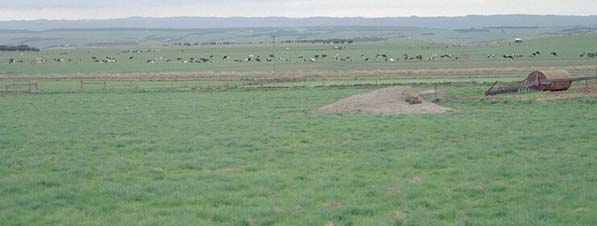 Site SW21 Landscape |
Soil Profile Morphology:
Surface Soil
| A1 | 0-20 cm | Black (10YR2/1); fine sandy loam; weak coarse blocky, parting to medium blocky structure; weak to firm consistence moist; pH 4.9; clear change to: | 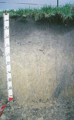 Site SW21 profile photo. |
| A2 | 20-40 cm | Dark greyish brown (10YR4/2); light fine sandy clay loam; weak to moderate medium polyhedral structure; firm consistence moist; very few (<1%) ferromanganiferous nodules (5 mm size); some rusty root channel mottling present; pH 4.8; clear change to: | |
| Subsoil | |||
| B1 | 40-60 cm | Dark greyish brown (10YR4/2) with yellowish brown (10YR5/8) and light yellowish brown (10YR6/4) mottles; fine sandy clay loam; weakly structured; very firm consistence moist; pH 4.8; gradual change to: | |
| B21 | 60-90 cm | Light brownish grey (10YR6/2) with yellowish brown (10YR5/8) mottles; light clay; weak to moderate coarse blocky, parting to medium blocky structure; firm consistence moist; pH 4.7; gradual change to: | |
| B22 | 90+ cm | Light brownish grey (10YR6/2) with yellowish brown (10YR5/8) mottles; light medium clay; weak to moderate coarse blocky, parting to medium blocky structure; very few (1%) iron nodules (5-10 mm size) and quartz fragments (2-3 mm size); pH 4.6. | |
Key Profile Characteristics:
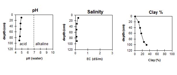
pH | Salinity Rating | |||
Surface (A1 horizon) | Very Strongly Acid | Low | Non-Sodic | None |
Subsoil (B21 horizon) | Very Strongly Acid | Very Low | Non-Sodic | None |
Deeper subsoil (at 90+ cm) | Very Strongly Acid | Very Low | Non-Sodic | None |
 |
Horizon | Horizon Depth (cm) | pH (water) | pH CaCl2 | EC 1:5 | Exchangeable Cations | |||
Ca | Mg | K | Na | |||||
meq/100g | ||||||||
A1 | 0-20 | 4.9 | 4.3 | 0.22 | 6.2 | 0.7 | 0.4 | 0.1 |
A2 | 20-40 | 4.8 | 4.1 | 0.1 | 0.7 | 0.5 | 0.05 | 0.05 |
B1 | 40-60 | 4.8 | 4.2 | 0.08 | 0.4 | 0.3 | 0.05 | 0.05 |
B21 | 60-90 | 4.7 | 4.1 | 0.08 | 0.3 | 0.4 | 0.05 | 0.05 |
B22 | 90+ | 4.6 | 4 | 0.1 | 0.3 | 0.6 | 0.05 | 0.05 |
Horizon | Horizon Depth (cm) | Field Capacity pF2.5 | Wilting Point pF4.2 | Coarse Sand (0.2-2.0 mm) | Fine Sand (0.02-0.2 mm) | Silt (0.002-0.02 mm) | Clay (<0.002 mm) |
A1 | 0-20 | 31 | 20 | 26 | 36 | 11 | 10 |
A2 | 20-40 | 19 | 8 | 25 | 40 | 15 | 14 |
B1 | 40-60 | 18 | 7 | 26 | 40 | 14 | 17 |
B21 | 60-90 | 20 | 8 | 24 | 39 | 10 | 24 |
B22 | 90+ | 22 | 11 | 21 | 34 | 15 | 31 |
Profile Described By: Mark Imhof and Austin Brown, August 1998.
© State of Victoria (Agriculture Victoria) 1996 - .

This work, Victorian Resources Online, is licensed under a Creative Commons Attribution 4.0 licence. You are free to re-use the work under that licence, on the condition that you credit the State of Victoria (Agriculture Victoria) as author, indicate if changes were made and comply with the other licence terms.
The licence does not apply to ‘branding’ or some ‘images or photographs’ that may be owned by third parties. We ask you to seek prior approval to use images using the VRO feedback form. Access to higher quality images can also be provided on request.
This page was last updated on .