
Soil/Landform Unit 95
Landform Unit Description
Page top
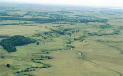 Upper Barwon River floodplain south of Birregurra |
0.63% of CMA region The floodplain of the Barwon River and its tributaries extend from the foothills of the northern side of the Otway Range to the basalt plains near Winchelsea and encompass a comparatively wide climatic variation. The vegetation reflects these changes, with tall open forests of Eucalyptus viminalis and E. ovata occurring in the south, and woodlands of E. camaldulensis dominating in the north. The soils also show a gradual transition from acid freely drained profiles (gradational soils) to heavier neutral soils as the influence of basalt derived alluvium increases towards the north. Flooding and siltation are common on these plains. Waterlogging of soils is a problem, particularly on low-lying areas such as cut-off meanders and infilled swamps. Gully erosion and streambank erosion are also common. |  |
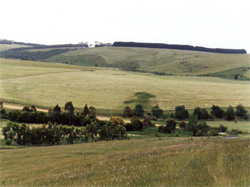 Broad alluvial plains near Pennyroyal | 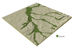 |
 | 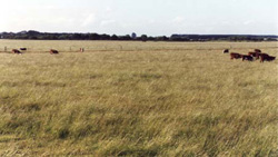 Introduced perennial pasture of the floodplain |
Component | 1 | 2 | 3 |
Proportion of soil-landform unit | 5% | 85% | 10% |
| CLIMATE Rainfall (mm) | Annual: 600-1000, lowest January (30), highest August (80) | ||
| Temperature (oC) | Annual: 13, lowest July (8), highest February (19) | ||
| Seasonal growth limitations | Temperature: less than 10oC (av.) June-August (also September in higher rainfall areas) Precipitation: less than potential evapotranspiration October-April in lower rainfall areas, November-March in higher rainfall areas | ||
| GEOLOGY Age and lithology | Recent alluvium-sand, silt, clay and gravel | ||
| Geomorphology | |||
| LANDUSE | Dairy farming; cropping; sheep and beef cattle grazing | ||
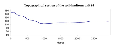
| TOPOGRAPHY Landscape | Alluvial floodplain of the Barwon Rivr and its tributaries with numerous cut-off meanders | ||
| Elevation range (m) | 90-150 | ||
| Local relief (m) | 3 | ||
| Drainage pattern | Deranged with major meandering channel | ||
| Drainage density (km/km2) | 3.7 | ||
| Landform | Plains | ||
| Landform element | Rise | Flat plain | Streambank, infilled meanders |
| Slope and range (%) | 4 (1-6) | 1 (0-2) | 2 (1-8) |
| Slope shape | Convex | Straight | Convex |
| NATIVE VEGETATION Structure | Woodland | ||
| Dominant species | E. ovata, E. viminalis, Acacia melanoxylon, in north E. camaldulensis | ||
| SOIL Parent material | Sandy alluvium | Clayey alluvium | Sandy alluvium |
| Description (Corangamite Soil Group) | Brown sandy loam soils (34) | Grey gradational soils (34) | Brown sandy loam soils (34) |
| Soil type sites | - | OTR733 | - |
| Surface texture | Fine sandy loam | Fine sandy clay loam | Fine sandy loam |
| Permeability | Very high | Moderate | Very high |
| Depth (m) | >2 | >2 | >2 |
| LAND CHARACTERISTICS, POTENTIAL AND LIMITATIONS | High permeability and leaching lead to nutrient decline. | High seasonal watertable leads to waterlogging, soil compaction and salting. Dispersbile clay subsoils are prone to gully and tunnel erosion. High discharge rates along some watercourses lead to flooding and siltation. | High discharge rates and weakly structured soils lead to stream bank erosion and siltation. High seasonal watertables lead to waterlogging. |
© State of Victoria (Agriculture Victoria) 1996 - .

This work, Victorian Resources Online, is licensed under a Creative Commons Attribution 4.0 licence. You are free to re-use the work under that licence, on the condition that you credit the State of Victoria (Agriculture Victoria) as author, indicate if changes were made and comply with the other licence terms.
The licence does not apply to ‘branding’ or some ‘images or photographs’ that may be owned by third parties. We ask you to seek prior approval to use images using the VRO feedback form. Access to higher quality images can also be provided on request.
This page was last updated on .