
Soil/Landform Unit 81
Landform Unit Description
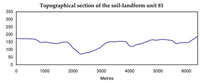
Page top
 Dissection of the remnant ferruginised plateau (Unit 336) has lead to development of steep slopes and extensive drainage development |
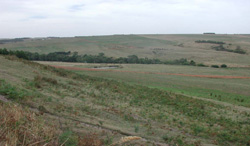
1.32% of CMA region Tomahawk Creek and its tributaries have dissected out deep valleys with characteristic north-north-west and south-south-east oriented parallel ridges and spurs. Small remnants of ferruginised plateau on the high parts of the landscape are bounded by scarps of which ferricrete outcrops. Neogene sand is often exposed in a narrow band below these scarps, and springs are often present at this level. Silt and clay are the more common parent materials on long straight slopes leading down to the valley floor. Small dissected terraces are found along the wider valleys with defined drainage. The terrain to the south and east of Tomahawk Creek shows a lower local relief than the area to the north and west. Areas of ferruginised plateau are often wider and surrounding slopes are shorter and more gentle. Site drainage is affected by the more subdued relief. Woodlands and low woodlands appear to have been more common in this area, with open forests to the north and west. Most of this unit has been cleared as part of the Heytesbury Soldier Settlement Scheme, and dairy farming is the main land use. Subsoils on many slopes are dispersible and gully and tunnel erosion is quite active. Some landslips have occurred, particularly below springs emerging at the base of scarps. |  |
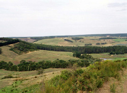 Dissected valleys near the Saddlecloth Plain | 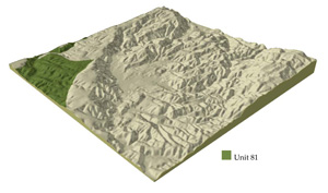 |
 | 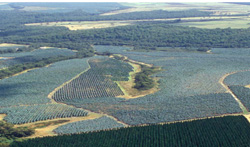 Pine and blue gum plantations are common on this landscape and the neighbouring Kennedys Creek landsystem (soil-landform unit 87) |
Component | 1 | 2 | 3 | 4 | 5 | 6 |
Proportion of soil-landform unit | 15% | 6% | 10% | 50% | 9% | 10% |
| CLIMATE Rainfall (mm) | Annual: 850-1050, lowest January (40), highest August (125) | |||||
| Temperature (oC) | Annual: 13, lowest July (8), highest February (19) | |||||
| Seasonal growth limitations | Temperature: less than 10oC (av.) June-August Precipitation: less than potential evapotranspiration November-March | |||||
| GEOLOGY Age and lithology | Pliocene ferruginised sand and clay | Miocene unconsolidated marine marl sand, silt and clay | ||||
| Geomorphology | ||||||
| LANDUSE | Cleared areas: Mainly dairy farming; some beef cattle grazing Uncleared areas: Hardwood forestry for sawlogs, some posts and poles; gravel extraction; nature conservation | |||||
| TOPOGRAPHY Landscape | Deep valley dissected out from lateritic plateaux | |||||
| Elevation range (m) | 50-160 | |||||
| Local relief (m) | 70 | |||||
| Drainage pattern | Trellis predominantly, some dendritic areas | |||||
| Drainage density (km/km2) | 2.5 | |||||
| Landform | Plateaux remnants | Scarp | Valley floor | |||
| Landform element | - | Upper slope | Upper slope | Mid slope | Lower slope | |
| Slope and range (%) | 1 (0-3) | 28 (13-40) | 13 (8-18) | 12 (8-20) | 5 (1-8) | 0 (0-2) |
| Slope shape | Straight | Concave | Straight | Straight | Straight | Concave |
| NATIVE VEGETATION Structure | Open forest | Open forest | Woodland | Open forest | Low woodland | Woodland |
| Dominant species | E. obliqua, E. baxteri | E. obliqua, occasionally E. viminalis | E. radiata, E. baxteri, E. viminalis | E. ovata, E. obliqua, E. radiata, E. baxteri | E. radiata, E. ovata | E. viminalis, E. ovata |
| SOIL Parent material | Lateritic remnants | Colluvial lateritic ironstone | Siliceous sand | Sandy clay (in situ) | Colluvial/alluvial and over sandy clay | Sand clay alluvium |
| Description (Corangamite Soil Group) | Stony red gradational soils (7) | Grey sand soils (29) | Grey gradational soils (34) | |||
| Soil type sites | - | OTR742 | OTR750 | OTR737 | OTR733 | |
| Surface texture | Sandy loam | Gravelly sandy loam | Coase sandy loam | Sandy loam | Sandy loam | Sandy loam |
| Permeability | Moderate | Very high | Very high | Low | Very low | Very low |
| Depth (m) | 1.6 | 1.0 | >2 | >2 | >2 | >2 |
| LAND CHARACTERISTICS, POTENTIAL AND LIMITATIONS | Low ineherent fertility and phosphorus fixation lead to nutrient decline. Leaching of salts leads to increased salinity of drainage waters. | Steep slopes with weakly structured surfaces of low water holding capacity are prone to sheet erosion. Low inherent fertility and high permeability lead to nutrient decline. | Emergence of springs from these perennial aquifers leads to seasonal waterlogging and soil compaction. Permeable soils of low inherent fertility are prone to nutrient decline. | Highly dispersible clay subsoils of low permeability receiving seepage water are prone to gully and tunnel erosion and to landslips and slumping. | Dispersible soils of low permeability receiving seepage water are prone to gully and tunnel erosion, waterlogging and surface compaction. Permeable surfaces of low inherent fertility are prone to nutrient decline. | Dispersible clay subsoils of low permeability receiving rapid runoff from surrounding hills are prone to gully erosion. Rising watertables and low permeabilities lead to seasonal waterlogging and soil compaction. |
© State of Victoria (Agriculture Victoria) 1996 - .

This work, Victorian Resources Online, is licensed under a Creative Commons Attribution 4.0 licence. You are free to re-use the work under that licence, on the condition that you credit the State of Victoria (Agriculture Victoria) as author, indicate if changes were made and comply with the other licence terms.
The licence does not apply to ‘branding’ or some ‘images or photographs’ that may be owned by third parties. We ask you to seek prior approval to use images using the VRO feedback form. Access to higher quality images can also be provided on request.
This page was last updated on .