
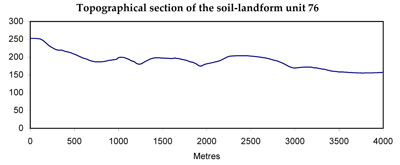
Soil/Landform Unit 76
Landform Unit Description
Page top
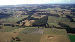 Pockets of remnant woodlands generally are found on crests and upper slopes of this landscape. |
0.49% of CMA region Paleogene and Neogene quartzitic sands outcrop in many areas north and west of the Otway Range. Widespread surface redistribution of this sand has resulted in development of a gentle landscape with sands overlying more clayey material in specified areas. The largest area is east of Kawarren in the catchment of Porcupine Creek, and another extensive area is found in the upper reaches of Tomahawk Creek. Somewhat steeper slopes with a predominance of deep relatively uniform sands occur to the east of Forrest, while the area near Princetown has broader crests and narrower drainage lines. Hardpans are a feature of the soils and the impeded drainage leads to waterlogging on many sites. The native vegetation consists of woodlands of Eucalyptus nitida and E. radiata, with closed scrubs of shrub species in the drainage lines. Clearing of these areas for agriculture has been attempted in many areas, but impeded drainage on sites with hardpans and excessive drainage on sites without them create management difficulties. Deep ripping of the hardpans may improve site drainage, but low soil pH and low fertility also have to be contended with for successful pasture establishment. Most areas remain as wildlife habitats, with the exceptions of one area near Princetown and part of the area near Tomahawk Creek, which border the Heytesbury Soldier Settlement Scheme. |
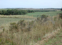 Lower colluvial slopes of gentle long rises | 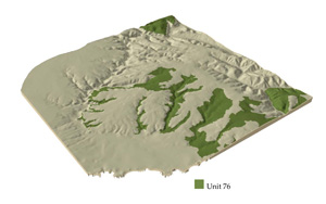 |
 |
Component | 1 | 2 | 3 | 4 | 5 | 6 |
Proportion of soil-landform unit | 30% | 25% | 15% | 15% | 5% | 10% |
| CLIMATE Rainfall (mm) | Annual: 800-1000, lowest January (40), highest August (120) | |||||
| Temperature (oC) | Annual: 13, lowest July (8), highest February (18) | |||||
| Seasonal growth limitations | Temperature: less than 10oC (av.) June-August Precipitation: less than potential evapotranspiration late October-March | |||||
| GEOLOGY Age and lithology | Paleogene unconolidated mudstone, sandstone | Neogene unconsolidated marine marl and fluvial sand, clay and silt | ||||
| Geomorphology | ||||||
| LANDUSE | Uncleared areas: Nature conservation; water supply; sand and gravel extraction; hardwod and forestry for posts, poles and fuel Minor cleared areas: Beef cattle grazing; water supply | |||||
| TOPOGRAPHY Landscape | Undulating plains | |||||
| Elevation range (m) | 60-230 | |||||
| Local relief (m) | 45 | |||||
| Drainage pattern | Trellis | |||||
| Drainage density (km/km2) | 2.5 | |||||
| Landform | Rises | Terraces | Drainage lines | |||
| Landform element | Crest and slope | Upper slope | Mid slope | Lower slope | - | - |
| Slope and range (%) | 21 (9-38) | 9 (2-21) | 5 (2-11) | 16 (5-33) | 2 (0-5) | 0 (0-1) |
| Slope shape | Convex | Convex | Linear | Convex | Linear | Linear |
| NATIVE VEGETATION Structure | Woodland | Woodland | Open woodland | Woodland | Open forest | Closed scrub |
| Dominant species | E. radiata, E. nitida | E. raidata, E. nitida | E. radiata, E. nitida | E. radiata, E. nitida, E. ovata | E. ovata, E. viminalis, E. radiata, E. baxteri | Melaleuca squarrosa, Cassuarine littoralis, Aotus ericoides |
| SOIL Parent material | Woodland | Low woodland | Open woodland | Woodland | Open forest | Closed scrub |
| Description (Corangamite Soil Group) | Grey sand soils (29) | Grey sand soils with hardpans (29) | Grey sand soils, structured clay underlay (22) | Grey sand soils, structured clay underlay (22) | Grey sand soils, structured clay underlay (22) | Black sand soils (34) |
| Soil type sites | OTR742 | OTR737 | - | OTR737 | OTR609, OTR739 | |
| Surface texture | Loamy sand | Loamy sand | Sandy loam | Sandy loam | Sandy loam | Silty loam |
| Permeability | Very high | Very low | Very low | Low | Very low | High |
| Depth (m) | >2 | 0.8 | >2 | >2 | >2 | >2 |
| LAND CHARACTERISTICS, POTENTIAL AND LIMITATIONS | Very low inherent fertility and high permeability lead to nutrient decline. Steeper slopes with compacted soils are prone to sheet, rill and scour gully erosion. | Hardpans restrict drainage, leading to seasonal waterlogging. Very low inherent fertility and leaching of highly acidic permeable surfaces lead to nutrient decline. | Low permeability and seasonal perched watertables lead to waterlogging and soil compaction. | Weakly structured soils of low permeability on steeper slopes are prone to sheet erosion. | Low permeability and seasonal perched watertables lead to waterlogging and soil compaction. | High watertables lead to waterlogging and soil compaction. Runoff from adjacent hills leads to flooding and siltation. |
© State of Victoria (Agriculture Victoria) 1996 - .

This work, Victorian Resources Online, is licensed under a Creative Commons Attribution 4.0 licence. You are free to re-use the work under that licence, on the condition that you credit the State of Victoria (Agriculture Victoria) as author, indicate if changes were made and comply with the other licence terms.
The licence does not apply to ‘branding’ or some ‘images or photographs’ that may be owned by third parties. We ask you to seek prior approval to use images using the VRO feedback form. Access to higher quality images can also be provided on request.
This page was last updated on .