
Soil/Landform Unit 73
Landform Unit Description
Page top
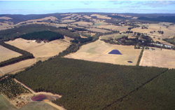 Steep rolling hills of the Pennyroyal landscape with softwood plantations in the foreground north-east of Deans Marsh |
0.82% of CMA region Along the northern periphery of the Otway Range, flat-topped spurs and ridges form an irregular band of foothills from Wormbete Creek to Barwon Downs. The terrain is variable, with steep slopes leading away from these gentle hill crests to slopes upwards towards the Otway Range and becomes narrower as the local relief increases. The gentle parts of the landscape are formed on Paleogene clay, silt and sand. These sediments overlie Cretaceous sandstones and mudstones, which outcrop on steep slopes on the valley sides. Soil and vegetation reflect changes in the parent material, with the soils on the upper parts of the landscape being somewhat deeply weathered with sandy surface horizons in contrast to loam or clay loam soils on the Cretaceous outcrops. Clearing has been widespread and sheep and beef cattle grazing as well as dairy farming are the main land uses. Some hardwood is logged from forested areas, and softwood plantations have been established in the east. Poor management of these hills can lead to rapid surface runoff along the valleys creating problems of gully erosion, siltation and flooding further downstream. | 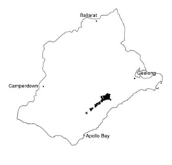 |
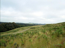 Across slope with sands and bracken prominent on cleared land | 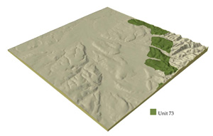 |
 | 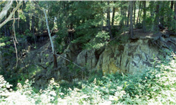 Extensive deep gully erosion along the valley floor of steep slopes |
Component | 1 | 2 | 3 | 4 | 5 |
Proportion of soil-landform unit | 35% | 15% | 35% | 12% | 3% |
| CLIMATE Rainfall (mm) | Annual: 700-1050, lowest January (35), highest August (80) | ||||
| Temperature (oC) | Annual: 12, lowest July (8), highest February (18) | ||||
| Seasonal growth liitations | Temperature: less than l0oC (av.) June–September Precipitation: less than potential evapotranspiration November-March | ||||
| GEOLOGY Age and lithology | Cretaceous fluvio-volcanic sandstone and mudstone | Recent alluvial clay, silt and sand | |||
| Geomorphology | |||||
| LANDUSE | Cleared areas: Sheep and beef cattle grazing; dairy farming; water supply Uncleared areas: Hardwood forestry for some sawlogs, posts and poles; softwood plantations; nature conservation; water supply; gravel extraction; passive recreation | ||||
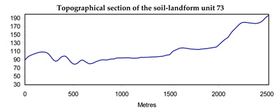
| TOPOGRAPHY Landscape | Steep rolling hills on the northern periphery of the Otway RAnge | ||||
| Elevation range (m) | 135-300 | ||||
| Local relief (m) | 65 | ||||
| Drainage pattern | Dendritic | ||||
| Drainage density (km/km2) | 2.2 | ||||
| Landform | Hills | Valley Floors | |||
| Landform element | Gentle crest | Upper slope and crest | Gentle upper slope | Steep lower slope | - |
| Slope and range (%) | 3 (0-15) | 7 (0-25) | 15 (3-25) | 30 (5-45) | 1 (0-2) |
| Slope shape | Convex | Convex | Linear | Linear | Concave |
| NATIVE VEGETATION Structure | Open forest | Open forest | Open forest | Open forest | Tall open forest |
| Dominant species | E. obliqua, E. ovata, E. radiata, E. aromaphloia, E. nitida | E. obliqua, E. raidata, E. nitida, E. viminalis | E. obliqua, E. viminalis, E. radiata, E. ovata, Acacia melanoxylon | E. obliqua, E. radiata, E. cypellocarpa | E. obliqua, E. cypellocarpa, E. globulus |
| SOIL Parent material | Clay, silt and sand, often deeply weathered | Sand and clay | Clay, silt and sand | In situ weathered sandstone and mudstone | Alluvium |
| Description (Corangamite Soil Group) | Brown, grey or yellow gradation soils, weak structure (29) | Brown texture contrast soils (6) | Grey gradational soils (34) | ||
| Soil type sites | CLRA15, OTR733 | ||||
| Surface texture | Sandy loam | Loamy sand | Fine sandy loam | Loam | Sandy loam - clay loam |
| Permeability | Moderate | High | Low | Moderate | Low |
| Depth (m) | >2 | >2 | >2 | 0.8 | >2 |
| LAND CHARACTERISTICS, POTENTIAL AND LIMITATIONS | Low inherent fertility and phosphorus fixation lead to nutrient decline. Weakly structured surface soils on steeper slopes are prone to sheet erosion. | Low inherent fertility and high permeability lead to nutrient decline. Weakly structured soils on steepest slopes are prone to sheet erosion. | Dispersible clay subsoils on steep slopes are prone to gully erosion. Soils of low permeability on steep slopes are prone to sheet erosion. | Steep slopes lead to sheet erosion, particulary on dry aspects. Clay subsoils on steep slopes subject to periodic saturation are prone to landslips. | High seasonal watertable and low permeability lead to seasonal waterlogging soil compaction and soil salting. High discharge rates, Dispersible clay suboils and dispersible sandy clay parent material of low mechanical strength lead to gully and tunnel erosion. |
© State of Victoria (Agriculture Victoria) 1996 - .

This work, Victorian Resources Online, is licensed under a Creative Commons Attribution 4.0 licence. You are free to re-use the work under that licence, on the condition that you credit the State of Victoria (Agriculture Victoria) as author, indicate if changes were made and comply with the other licence terms.
The licence does not apply to ‘branding’ or some ‘images or photographs’ that may be owned by third parties. We ask you to seek prior approval to use images using the VRO feedback form. Access to higher quality images can also be provided on request.
This page was last updated on .