
Soil/Landform Unit 64
Landform Unit Description
Page top
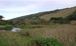 Steep southerly facing slopes that are prone to landslips at the junction of the Great Ocean Road and Wild Dog Creek |
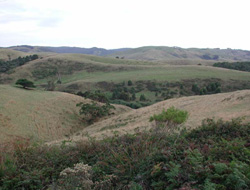
1.56% of CMA region From Cinema Point to Moonlight Head, much of the coastline consists of steep slopes, coastal cliffs and rocky shore platforms. These coastal margins of the range have a milder maritime climate than those areas further inland, and receive a lower rainfall. Inland from the coast the topography consists of steeply dissected spurs and ridges with cliffs and waterfalls. The steepest slopes have shallow stony soils with areas of rock outcrop. Most slopes, however, have moderately deep texture contrast soils. On inland slopes with a southerly aspect, no strong profile differentiation has occurred and profiles are gradational. Tall open forests, with understorey species such as Bedfordia salicina, Olearia spp. and Pomaderis spp., occupy these sites. On the texture contrast soils the trees are shorter with a more open understorey. Large tracts of this unit have been cleared and dairy farming is a major land use. The steep slopes and deep valleys create severe management problems. The coastal areas between Cinema Point and Apollo Bay have been popular for residential development. Landslips are very common and sheet erosion has been widespread. | 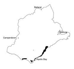 |
 Cleared upper crests and slopes | 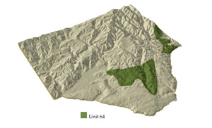 |
 | 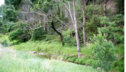 Drainage line at the base to steep to precipitous slopes |
Component | 1 | 2 | 3 | 4 | 5 | 6 |
Proportion of soil-landform unit | 7% | 8% | 35% | 5% | 35% | 10% |
| CLIMATE Rainfall (mm) | Annual: 850-1200, lowest January (45), highest August (120) | |||||
| Temperature (oC) | Annual: 13, lowest July (9), highest February (17) | |||||
| Seasonal growth limitations | Temperature: less than 10oC (av.) July Precipitation: less than potential evapotanspiration mid November - mid March | |||||
| GEOLOGY Age and lithology | Cretaceous fluvio-volcanic sandstone and conglomerate, minor Paleogene marine marl | |||||
| Geomorphology | ||||||
| LANDUSE | Uncleared areas: Hardwood forestry for sawlogs, posts and poles; softwood plantations; nature conservation; active and passive recreation; landscape conservation; water supply Minor cleared areas: Dairy farming and beef cattle grazing on mainly unimproved pastures, residential | |||||
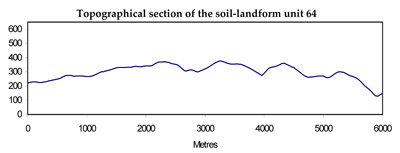
| TOPOGRAPHY Landscape | Deeply dissected hills of the Otway Range | |||||
| Elevation range (m) | 0-400 | |||||
| Local relief (m) | 150 | |||||
| Drainage pattern | Dendritic with some radial areas | |||||
| Drainage density (km/km2) | 4.0 | |||||
| Landform | Coastal cliffs | Hills | ||||
| Landform element | Steep lower slope | Upper gentler slope | North and west facing slopes and upper slope | Lower slope and drainage line | South and east facing slopes | Steepest slope |
| Slope and range (%) | 60 (30-75) | 30 (15-45) | 45 (5-55) | 20 (1-35) | 45 (5-65) | 60 (20-70) |
| Slope shape | Linear | Convex | Linear | Concave | Linear | Linear |
| NATIVE VEGETATION Structure | Open scrub | Woodland | Open forest | Tall open forest | Tall open forest | Woodland |
| Dominant species | Casuarina stricta, Cassinia aculeata, E. obliqua, Alyxia buxifolia, Leucopogon parviflorus | E. obliqua, E. globulus, E. viminalis | E. obliqua, E. sideroxylong, E. radiata, E. cypellocarpa, E. globulus | E. ovata, E. globulus, E. cypellocarpa, Acacia melanoxylon | E. cypellocarpa, E. globulus, E. obliqua, E. ovata | E. radiata E. sideroxylong, E. cypellocarpa, occasionally E. viminalis, E. globulus |
| SOIL Parent material | Colluvium | In situ weathered sandstone and conglomerate | In situ weathered sandstone and conglomerate | Alluvium | In situ weathered sandstone and conglomerate | Colluvium |
| Description (Corangamite Soil Group) | Stony brown gradational soils (7) | Brown texture contrast soils (6) | Brown texture contrast soils (6) | Brown gradational soils, weak structure (34) | Brown gradational soils (7) | Stony brown gradational soils (7) |
| Soil type sites | OTR732 | OTR732 | ||||
| Surface texture | Fine sandy loam | Fine sandy clay loam | Fine sandy clay loam | Silty loam | Fine sandy clay loam | Fine sandy loam |
| Permeability | Very high | Moderate | Moderate | High | High | Very high |
| Depth (m) | 0-3 | 0.9 | 0.9 | >2 | 0.9 | 0.5 |
| LAND CHARACTERISTICS, POTENTIAL AND LIMITATIONS | Native vegetation is sensitive to salt pruning and disturbance. Dispersible soils on steep slopes are prone to sheet erosion. Marine undercutting and saturation of soils lead to landlips. | Native vegetation is sensitive to disturbance and to salt pruning. Dispersible soils on moderate slopes are prone to sheet erosion. Periodic saturation of dispersible clay subsoils leads to landslips and slumping of road batters. | Dry aspect, steep slopes and weakly structured surfaces lead to sheet erosion. Clay subsoils on steep slopes subject to periodic saturation are prone to landslips. | Weakly structured soils receiving runoff are prone to scour gullying, siltation, flooding, and compaction of surface structure. | Steep slopes and weakly structured surfaces lead to sheet erosion. Clay subsoils on steep slopes subject to periodic saturation are prone to landslips. | Stony shallow soils of weak structure slopes are prone to capacity on steep and low water holding sheet erosion and landslides. |
© State of Victoria (Agriculture Victoria) 1996 - .

This work, Victorian Resources Online, is licensed under a Creative Commons Attribution 4.0 licence. You are free to re-use the work under that licence, on the condition that you credit the State of Victoria (Agriculture Victoria) as author, indicate if changes were made and comply with the other licence terms.
The licence does not apply to ‘branding’ or some ‘images or photographs’ that may be owned by third parties. We ask you to seek prior approval to use images using the VRO feedback form. Access to higher quality images can also be provided on request.
This page was last updated on .