
Soil/Landform Unit 60
Landform Unit Description
Page top
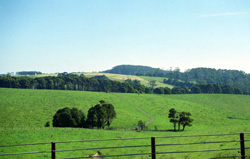 Cleared rolling hills at Lavers Hill |
1.08% of CMA region Along the crest of the wettest parts of the Otway Range lies a rolling plain with rounded hills and shallow valleys. This area has one of the highest annual rainfalls in Victoria, averaging almost 2000 mm at Weeaproinah. Prior to settlement late last century, tall open forests of Eucalyptus regnans and associated species dominated the landscapes, but now most areas have been cleared for agriculture. Some stands of timber remain and other areas are being regenerated to form climax communities of E. regnans. Agricultural uses are dairying, beef cattle grazing and cropping. The cool climate, remoteness and freely drained soils make the area suitable for seed potato production. The perennial nature of many of the creeks and drainage lines gives the area high water catchment values. Conflict also arises between its high scenic appeal as a rural landscape and the conversion of farmland to softwood plantations. |  |
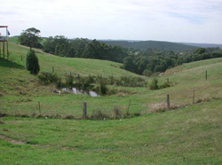 Shallow valley dissection with prominent gully erosion |  |
| 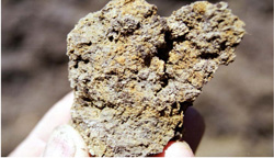 Mottled soil ped from the subsoil of the crest and upper slope element |

Component | 1 | 2 | 3 |
Proportion of soil-landform unit | 5% | 85% | 10% |
| CLIMATE Rainfall (mm) | Annual: 1550-1950, lowest January (80), highest August (210) | ||
| Temperature (oC) | Annual: 10, lowest July (6), highest February (15) | ||
| Seasonal growth limitations | Temperature: less than 10oC (av.) May-October Precipitation: less than potential evapotranspiration late December - early February | ||
| GEOLOGY Age and lithology | Cretaceous fluvio-volcanic sandstone, siltstone and mudstone | ||
| Geomorphology | |||
| LANDUSE | Cleared area: Dairy farming; beef cattle grazing; row crops (seed potatoes); water supply Uncleared areas: Softwood forestry, hardwood forestry for sawlogs and pulpwood; nature conservation; passive recreation; water supply | ||
| TOPOGRAPHY Landscape | Rolling hills along the crest of the Otway Range | ||
| Elevation range (m) | 340-560 | ||
| Local relief (m) | 45 | ||
| Drainage pattern | Dendritic with some tellis and radial areas | ||
| Drainage density (km/km2) | 3.0 | ||
| Landform | Hills | ||
| Landform element | Slope | Crest and slope | Lower slope and drainage line |
| Slope and range (%) | 12 (2-5) | 12 (1-20) | 5 (1-8) |
| Slope shape | Convex | Convex | Concave |
| NATIVE VEGETATION Structure | Tall open forest | Tall open forest | Tall closed forest |
| Dominant species | E. regnans, E. obliqua, Acacia melanoxylon | E. regnans, E. obliqua, A. melanoxylong | Nothofagus cunninghamii, A. melanxoylong, E. regnans |
| SOIL Parent material | Deeply weathered in situ sandstone, siltstone and mudstone | In situ sandstone, siltstone and mudstone | Alluvium and colluvium |
| Description (Corangamite Soil Group) | Brown friable gradational soils (7) | Brown friable gradational soils (7) | |
| Soil type sites | OTR418 | OTR428 | |
| Surface texture | Loam | Clay loam | Loam |
| Permeability | High | Moderate | High |
| Depth (m) | 2.0 | 1.6 | >2 |
| LAND CHARACTERISTICS, POTENTIAL AND LIMITATIONS | High rainfall, high permeability and leaching plus loss of organic matter and soil structure upon disturbance lead to nutrient decline and soil compaction. Steeper slopes may be subseqently prone to sheet erosion. | High rainfall and moderate permeability lead to leaching of nutrients and losses in organic matter and soil structure. Steeper slopes are subsequently prone to sheet erosion. Clay subsoils on steeper slopes are subject to frequent saturation and are prone to landslips. | High seasonal watertables and runoff from surrounding slopes lead to waterlogging and soil compaction. |
© State of Victoria (Agriculture Victoria) 1996 - .

This work, Victorian Resources Online, is licensed under a Creative Commons Attribution 4.0 licence. You are free to re-use the work under that licence, on the condition that you credit the State of Victoria (Agriculture Victoria) as author, indicate if changes were made and comply with the other licence terms.
The licence does not apply to ‘branding’ or some ‘images or photographs’ that may be owned by third parties. We ask you to seek prior approval to use images using the VRO feedback form. Access to higher quality images can also be provided on request.
This page was last updated on .