
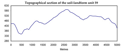
Soil/Landform Unit 59
Landform Unit Description
Page top
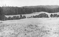 Farmland is very uncommon with some pine plantations scattered through this landscape |
0.71% of CMA region Disconnected remnants of an undulating plain are found on the high parts of the Otway Range from near the Parker River to Gentle Annie Hill. The wettest and most extensive part of this undulating plain comprises soil-landform unit 60. All other areas receive an annual rainfall of 1700 mm or less and the tall open forests, although they reach impressive heights, do not approach the 100 m stands reported for within soil-landform unit 60 prior to clearing. Most slopes and crests have moderately deep and fertile soils. The occurrence of extremely deep and friable soils in some areas seems to be related to a change in the nature of the Cretaceous beds. The depth to weathering parent material is often in excess of 2 m in these profiles. The remote nature of most of these plateau remnants has hindered their development for agriculture. Many of the areas originally cleared by early settlers have reverted to dense scrub while others have been regenerated to Eucalyptus regnans or other hardwood/softwood species. Landslips and loss of soil nutrients in such a wet climate are the main hazards to land use. | 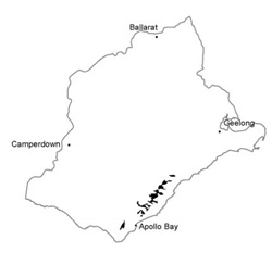 |
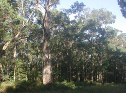 E. regnans and E. obliqua of a regrowth stand containing old stags | 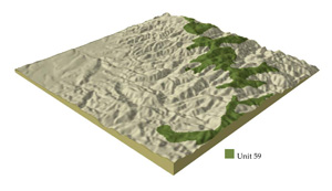 |
| 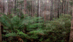 Tall open forest on the plateau of the Otway Ranges |
Component | 1 | 2 | 3 |
Proportion of soil-landform unit | 25% | 70% | 5% |
| CLIMATE Rainfall (mm) | Annual: 1200-1700, lowest February (65), highest June (170) | ||
| Temperature (oC) | Annual: 10, lowest July (6), highest February (5) | ||
| Seasonal growth limitations | Temperature: less than 10oC (av.) May-October Precipitation: less than potential evapotranspiration early December-February | ||
| GEOLOGY Age and lithology | Cretaceous fluvio-volcanic sandstone and conglomerate | ||
| Geomorphology | |||
| LANDUSE | Uncleared area: Hardwood forestry for sawlogs and pulpwood; softwood plantations; nature conservation; passive recreation; water supply Minor cleared areas: Some beef cattle grazing on unimproved pastures; most reverting to native forest or converted to pine plantations | ||
| TOPOGRAPHY Landscape | Rolling hills along the top of the Otway Range | ||
| Elevation range (m) | 400-670 | ||
| Local relief (m) | 60 | ||
| Drainage pattern | Dendritic pattern with some radial areas | ||
| Drainage density (km/km2) | 2.3 | ||
| Landform | Hills | ||
| Landform element | Upper slope | General slope | Lower slope |
| Slope and range (%) | 15 (1-25) | 15 (1-25) | 9 (1-12) |
| Slope shape | Convex | Convex | Concave |
| NATIVE VEGETATION Structure | Tall open forest | Tall open forest | Tall open forest |
| Dominant species | E. obliqua, Acacia melanoxylon, E. regnans, E. cypellocarpa | E. obliqua, E. cypellocarpa, E. regnans, Acacia melanoxylong, occasional E. ovata | E. regnans, E. cypellocarpa. E. obliqua, Acacia melanoxylong |
| SOIL Parent material | In situ deeply weathered sandstine and conglomerate | In situ weathered sandstone and conglomerate | Colluvium |
| Description (Corangamite Soil Group) | Brown friable gradational soils (7) | Brown friable gradational soils (7) | Brown friable gradational soils (7) |
| Soil type sites | OTR418, OTR736 | OTR414, OTR416, OTR748 | OTR428 |
| Surface texture | Loam | Clay loam | Loam |
| Permeability | High | High | High |
| Depth (m) | 1.8 | 1.3 | >2 |
| LAND CHARACTERISTICS, POTENTIAL AND LIMITATIONS | High rainfall and high permeability lead to leaching of nutrients and losses in organic matter and soil structure. Steeper slopes may be subsequently prone to sheet erosion. | High rainfall and moderate permeability lead to leaching of nutrients and losses in organic matter and soil structure. Steeper slopes are subsequently prone to sheet erosion. Clay subsoils on steeper slopes subject to frequent saturation are prone to landslips. | High seasonal watertable leads to waterlogging and soil compaction. |
© State of Victoria (Agriculture Victoria) 1996 - .

This work, Victorian Resources Online, is licensed under a Creative Commons Attribution 4.0 licence. You are free to re-use the work under that licence, on the condition that you credit the State of Victoria (Agriculture Victoria) as author, indicate if changes were made and comply with the other licence terms.
The licence does not apply to ‘branding’ or some ‘images or photographs’ that may be owned by third parties. We ask you to seek prior approval to use images using the VRO feedback form. Access to higher quality images can also be provided on request.
This page was last updated on .