
Soil/Landform Unit 50
Landform Unit Description
Page top
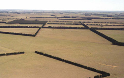 Cropped and grazed gentle basalt plains with shelter belts of cypress pine and radiata pine |
2.91% of CMA region The basaltic plains that occur throughout the Midlands of the Western Uplands as separate fragments are characterised by long gentle slopes with Plains Grassy Woodlands as the major vegetation class. The gently undulating plains in the east are bound by a steep scarp/slopes that define their margin with the valley of the Lal Lal Reservoir and Moorabool River. This dissection has produced steeply dissected terrain highlighting a wide diversity of geologies that are also found in varying quantities across the plains. The dominant soils are mottled texture contrast soils with minor occurrences of sporadic bleached subsurface horizons. The dominant soils of this unit also occur on the mounds and in the depression of gilgai areas. Other soils often found associated with gilgais are black texture contrast soils, other texture contrast soils with shallow surface horizons and black cracking clays. A few surface stones may occur in these gilgai areas. Land use includes beef cattle and sheep grazing, water supply, softwood plantations and residential development around the smaller communities. Erosion hazards are minimal except at scarps, which have a moderate susceptibility to soil loss. Areas with shallow stony gradational soils are susceptible to leaching of nutrients, and compaction is a problem on the flatter gilgaied areas. | 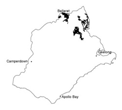 |
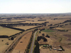 Looking north towards the higher sedimentary country of the Western Uplands | 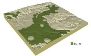 |
| 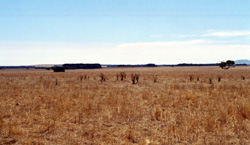 Gentle grassed plains near Meredith |
Component | 1 | 2 | 3 | 4 |
Proportion of soil-landform unit | 55% | 5% | 5% | 35% |
| CLIMATE Rainfall (mm) | Annual: 710 | |||
| Temperature (oC) | Minium 7, Maximum 18 | |||
| Precipitation less than potential evapotranspiration | October-March | |||
| GEOLOGY Age and lithology | ||||
| Geomorphology | ||||
| LANDUSE | Uncleared: Nature conservation Cleared: Beef cattle and sheep grazing; water supply; cropping (cereal); hoticulture; residential development | |||
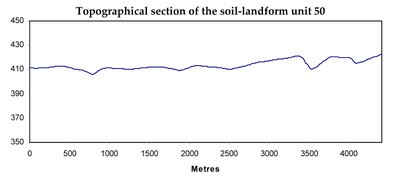
| TOPOGRAPHY Landscape | Gently undulating basalt plains | |||
| Elevation range (m) | 220-575 | |||
| Local relief (m) | 1-3 | |||
| Drainage pattern | Dendritic | |||
| Drainage density (km/km2) | 1.2 | |||
| Landform | Plains | Gentle rises | ||
| Landform element | Undulating plain | Drainage line | Depression | Roling hillslopes |
| Slope and range (%) | 2 (0-5) | 2 (0-5) | 1 (0-2) | 5 (3-10) |
| Slope shape | Straight | Concave | Concave | Convex |
| NATIVE VEGETATION Ecological Vegetation Class | Plains Grassy Woodland (1.9%) | |||
| SOIL Parent material | Basalt | Basaltic colluvium and alluvium | Basaltic colluvium and alluvium | Sandstone and shale |
| Description (Corangamite Soil Group) | Acidic mottled black texture contrast soils (31) and grey cracking clay (32) | Acidic mottled black texture contrast soils (32) and acidic and neutral mottled brown, grey or yellow texture contrast soils (31) | Acidic mottled brown, grey or yellow texture contrast soils (26) | |
| Soil type sites | ||||
| Surface texture | Fine sandy clay loam | Light medium clay, fine sandy clay | Fine sandy clay loam | Sandy loam |
| Permeability | Low | Low to very low | Very low | Moderate |
| Depth (m) | <2 | >2 | >2 | <1.5 |
| LAND CHARACTERISTICS, POTENTIAL AND LIMITATIONS | Texture contrast soil, moderate water holding capacity and moderate nutrient holding capacity in surface and subsurface soils, higher in deep subsoil. Low to very low permeability. Some stone. Strongly sodic subsoil. Moderate site drainage. Surface susceptible to compaction. | Texture contrast and uniform expansive clay soil, moderate water holding capacity and moderate nutrient holding capacity in surface and subsurface soils, higher in deep expansive subsoil. Low to very low permeability. Strongly sodic subsoil, possibly surface soil associated with poor drainage. Slow to very slow site drainage. | Texture contrast soil, moderate water holding capacity and moderate nutrient holding capacity in surface and subsurface soils, higher in deep subsoil. Low to very low permeability. Minor stone. Strongly sodic subsoil, possible surface soil associated with poor drainage. Slow to very slow site drainage. | Texture contrast soil, low water holding capacity and nutrient holding capacity in surface and subsurface soils, higher in deep subsoil. Low permeability. Some stone. Occasionally sodic subsoil, generally strongly acidic. Moderately rapid site drainage. Slight susceptibility to sheet and rill erosion. |
© State of Victoria (Agriculture Victoria) 1996 - .

This work, Victorian Resources Online, is licensed under a Creative Commons Attribution 4.0 licence. You are free to re-use the work under that licence, on the condition that you credit the State of Victoria (Agriculture Victoria) as author, indicate if changes were made and comply with the other licence terms.
The licence does not apply to ‘branding’ or some ‘images or photographs’ that may be owned by third parties. We ask you to seek prior approval to use images using the VRO feedback form. Access to higher quality images can also be provided on request.
This page was last updated on .