
Soil/Landform Unit 39
Landform Unit Description
[/p>]
Page top
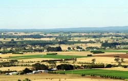 Vast volcanic red plains of the Midlands looking towards Dunnstown from Mount Warrenheip. The soils of this areas have some of the most prized in the catchment owing to their high inherent versatility and nutrient status. |
0.54% of CMA region The lava plains south of Ballarat are characterised by undulating plains and rises that support many agricultural enterprises. Vegetation classes include Herb-rich Foothill Forest and Plains Grassy Woodland with the dominant species being manna gum (E. viminalis), narrow leaf peppermint (E. radiata) and messmate stringybark (E. obliqua). This unit has sought after dark red gradational soils with profile depths of 150 cm on gentle slopes. Very few depressions occur with grey cracking clays and texture contrast soils. Agricultural land use is quite diverse and is predominantly potato cropping. Other land uses include beef cattle and sheep grazing, water supply, horticulture (including apples and other stone fruit), softwood plantations and residential development. Erosion hazards are minimal. Areas with shallow stony gradational soils are susceptible to leaching of nutrients, and compaction is a problem on the lower slopes and depressions. | 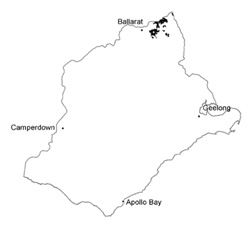 |
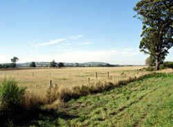 Potato cropping is the major land use of the gentle slopes | 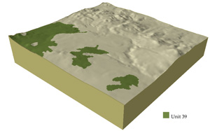 |
| 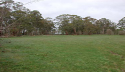 Remnant vegetation stand associated with stony rises contained within these red volcanic plains |
Component | 1 | 2 | 3 |
Proportion of soil-landform unit | 90% | 5% | 5% |
| CLIMATE Rainfall (mm) | Annual: 940 | ||
| Temperature (oC) | Minimum 6, Maximum 16 | ||
| Precipitation less than potential evapotranspiration | November-March | ||
| GEOLOGY Age and lithology | Pleistocene; basalt and minor river deposits, gravels, sands and clays | ||
| Geomorphology | |||
| LANDUSE | Uncleared: Water supply; nature conservation; passive and active recreation; hardwood forestry Cleared: Potato farming; beef cuttle and sheep grazing; horticulture (including stone fruits); softwood plantations; cropping (cereal); residential development | ||
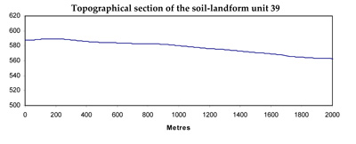
| TOPOGRAPHY Landscape | Gently undulting rises | ||
| Elevation range (m) | 487-736 | ||
| Local relief (m) | 5 | ||
| Drainage pattern | Dendritic | ||
| Drainage density (km/km2) | 1.6 | ||
| Landform | Undulating plains and rises | Terraces | |
| Landform element | Gentle slopes | Depressions | |
| Slope and range (%) | 3 (1-6) | 1 (1-2) | 1 (1-2) |
| Slope shape | Convex | Straight | Straight |
| NATIVE VEGETATION Ecological Vegetation Class | Herb-rich Foothill Forest (4%), Plains Grassy Wooland (3.3%) | ||
| Dominant species | E. viminalis, E. radiata, E. obliqua | E. viminalis, E. radiata, E. obliqua | E. viminalis, E. radiata |
| SOIL Parent material | In situ weathered rock | In situ weathered rock | Unconsolidated gravel, sand, silt and clay |
| Description (Corangamite Soil Group) | Red gradational soil, fine stucture (40) | Dark brown soil - variable (34) | |
| Soil type sites | |||
| Surface texture | Clay loam | Clay loam | Fine sandy clay loam |
| Permeability | High | Moderate to low | Moderate to low |
| Depth (m) | 2 | 1.5 | 2 |
| LAND CHARACTERISTICS, POTENTIAL AND LIMITATIONS | Slope exposure, leaching, overland flow, sheet erosion and nutrient decline are very minor. These soils have a high agricultural versatility. | Low subsoil permeability and hardsetting surfaces make the land vulnerable to waterlogging and compaction. | Low-lying areas receiving drainage are prone to waterlogging, overland flow, streambank erosion and gully erosion. |
© State of Victoria (Agriculture Victoria) 1996 - .

This work, Victorian Resources Online, is licensed under a Creative Commons Attribution 4.0 licence. You are free to re-use the work under that licence, on the condition that you credit the State of Victoria (Agriculture Victoria) as author, indicate if changes were made and comply with the other licence terms.
The licence does not apply to ‘branding’ or some ‘images or photographs’ that may be owned by third parties. We ask you to seek prior approval to use images using the VRO feedback form. Access to higher quality images can also be provided on request.
This page was last updated on .