
Soil/Landform Unit 204
Landform Unit Description
Page top
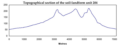
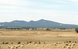 The You Yangs are a prominent residual granite of the Western Plains |
0.26% of CMA region This unit consists of undulating low hills on colluvium associated with the You Yangs, on the eastern border of the catchment. The granite derived colluvial slopes of the Western Plains includes the landform components crests and upper slopes, mid slopes and lower slopes. There is little dissection of this mantle. The soils range from sodic mottled brown or grey texture contrast soils (Sodosols, Chromosols), often with deep sandy upper soils on the crests to strongly sodic mottled brown or grey texture contrast soils (Sodosols) on mid and lower slopes. Rainfall is relatively low in this area and land use is generally grazing (sheep) with some cropping. Softwood plantations are also common on slopes. These soils are susceptible to sheet and rill erosion and possibly tunnel and gully erosion on steeper and lower slopes. | 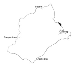 |
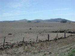 The colluvial slopes of the You Yangs are surrounded by alluvial and basalt plains | 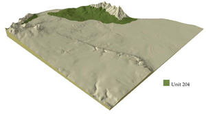 |
 |
Component | 1 | 2 | 3 | 4 |
Proportion of soil-landform unit | 15% | 30% | 47% | 8% |
| CLIMATE Rainfall (mm) | Annual: 510 | |||
| Temperature (oC) | Minimum 9, Maximum 20 | |||
| Precipitation: less than potential evapotranspiration | October–April | |||
| GEOLOGY Age and lithology | ||||
| Geomorphology | ||||
| LAND USE | Uncleared: Nature conservation Cleared: Hardwood and softwood plantations; beef cattle and sheep grazing; cropping (cereal) | |||
| TOPOGRAPHY Landscape | Colluvial slopes associated with the You Yangs | |||
| Elevation range (m) | 24–223 | |||
| Local relief (m) | 50 | |||
| Drainage pattern | Dendritic | |||
| Drainage density (km/km2) | 1.8 | |||
| Landform | Hills and slopes | Drainage lines | ||
| Landform element | Crests and upper slopes | Mid slopes | Lower slopes | |
| Slope and range (%) | 12 (6–20) | 8 (4–15) | 5 (2–10) | 2 (1–5) |
| Slope shape | Convex | Convex | Concave | Convex |
| NATIVE VEGETATION Ecological Vegetation Class | Hills Herb-rich Woodland (0.9%), Plains Grassy Woodland (0.3%) | |||
| SOIL Parent material | Colluvial clay, silt and sand | Colluvial clay, silt and sand | Colluvial clay, silt and sand | Alluvial clay, silt and sand |
| Description (Corangamite Soil Group) | Alkaline mottled brown, grey or yellow texture contrast soils (14) | Alkaline mottled brown, grey or yellow texture contrast soils (14) | Alkaline mottled brown, grey or yellow texture contrast soils (32) | |
| Soil type sites | ||||
| Surface texture | Coarse sandy clay loam, sandy loam | Sandy loam | Sandy loam | Sandy loam |
| Permeability | Moderate to high | Moderate | Low | Very low |
| Depth (m) | <1 | <2 | <2 | >2 |
| LAND CHARACTERISTICS, POTENTIAL AND LIMITATIONS | Rock outcrop or stony. Texture contrast with coarse sand component. Low nutrient holding capacity in upper soil, high in subsoil. Permeable surface sands of high acidity and low inherent fertility are prone to nutrient decline Moderately rapid site drainage. | Texture contrast with coarse sand component. Low nutrient holding capacity in upper soil, high in subsoil. Permeable surface sands of high acidity and low inherent fertility are prone to nutrient decline. Moderately rapid site drainage. | Texture contrast with coarse sand component. Low nutrient holding capacity in upper soil, high in subsoil. Permeable surface sands of high acidity and low inherent fertility are prone to nutrient decline. Slow to moderate site drainage. | Texture contrast with coarse sand component. Low nutrient holding capacity in upper soil (where little organic matter), high in subsoil. Permeable surface sands of high acidity and low inherent fertility are prone to nutrient decline. Very slow site drainage. |
© State of Victoria (Agriculture Victoria) 1996 - .

This work, Victorian Resources Online, is licensed under a Creative Commons Attribution 4.0 licence. You are free to re-use the work under that licence, on the condition that you credit the State of Victoria (Agriculture Victoria) as author, indicate if changes were made and comply with the other licence terms.
The licence does not apply to ‘branding’ or some ‘images or photographs’ that may be owned by third parties. We ask you to seek prior approval to use images using the VRO feedback form. Access to higher quality images can also be provided on request.
This page was last updated on .