
Soil/Landform Unit 195
Landform Unit Description
Page top
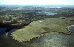 Plains, swamps, rivers and lakes of the Moolap Sunklands |
0.16% of CMA region This land unit lies to the east of Geelong and known as part of the Moolap Sunklands, consisting of low relief of undulating plains of colluvial and alluvial origin dropping to a recent level of flats and swamps. This unit is part of the Western Plains (alluvial group) with the Southern Uplands to the east. This unit is adjacent to the swamp and lake system of the Barwon River to the south and west, and the uplifted plateau of Neogene sediments to the east. The rise to the plateau is an escarpment that provides views to Geelong from townships such as Leopold. Much of the material for this unit is supposed to have come off the escarpment as colluvium. Little remnant vegetation occurs in this unit with less then <2% Plains Grassy Woodland found. Local relief is very low making this unit prone to inundation and limiting urban development to low density housing, sporting complexes and other recreational and conservation uses. This is accentuated by the presence of heavy sodic soils. | 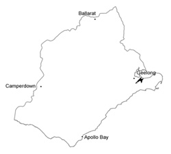 |
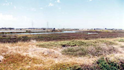
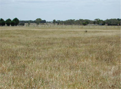 Broadacre grazing and low level development occupy this low relief undulating plain, which is subject to inundation | 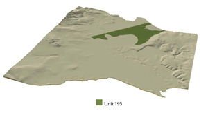 |
 |  Saline coastal flats form the edge of this unit to the north and west |
Component | 1 | 2 | 3 |
Proportion of soil-landform unit | 20% | 70% | 10% |
| CLIMATE Rainfall (mm) | Annual: 560 | ||
| Temperature (oC) | Minimum 10, Maximum 19 | ||
| Precipitation less than potential evapotranspiration | October–April | ||
| GEOLOGY Age and lithology | Recent fluvial and marine clay, sand, gravel and coastal sand dunes | ||
| Geomorphology | |||
| LANDUSE | Uncleared: Nature conservation Cleared: Sheep and beef cattle grazing; cropping (cereal) | ||
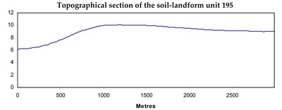
| TOPOGRAPHY Landscape | Gently undulating plain | ||
| Elevation range (m) | 5–20 | ||
| Local relief (m) | 3 | ||
| Drainage pattern | Deranged | ||
| Drainage density (km/km2) | 0.6 | ||
| Landform | Undulating plain | Floodplain and depressions | |
| Landform element | Gentle rises | Plain | Flat surface |
| Slope and range (%) | 3 (1-5) | 2 (1-4) | 0 (0-1) |
| Slope shape | Convex | Straight | Straight |
| NATIVE VEGETATION Ecological Vegetation Class | Plains Grassy Woodland (1.7%) | ||
| SOIL Parent material | Clay, silt and sand | Clay, silt and sand | Clay, silt and sand |
| Description (Corangamite Soil Group) | Grey-brown texture contrast and gradational soils (32) | Grey sand/clay soils with hardpans (31) | |
| Soil type sites | |||
| Surface texture | Loam, fine sandy | Loam, fine sandy, light clay | Light clay |
| Permeability | Low | Low to very low | Very low |
| Depth (m) | >2 | >2 | >2 |
| LAND CHARACTERISTICS, POTENTIAL AND LIMITATIONS | Texture contrast. Sodic, often expansive clay subsoil, low permeability when wet. Imperfect site drainage. Surface soil has low to moderate water holding capacity and nutrient holding capacity but moderate permability restricted by subsoil. | Texture contrast. Sodic, often expansive clay subsoil, low permeability when wet. Poor site drainage. Surface soil has low to moderate water holding capacity and nutrient holding capacity but moderate permability restricted by subsoil. | Heavy clay soil sometimes texture contrast. Sodic, often expansive clay subsoil, low permeability when wet. Very poor site drainage. Surface moderate to high water holding capacity and nutrient holding capacity but moderate permeability in dry state becomes very low when wet due to expansive clays. |
© State of Victoria (Agriculture Victoria) 1996 - .

This work, Victorian Resources Online, is licensed under a Creative Commons Attribution 4.0 licence. You are free to re-use the work under that licence, on the condition that you credit the State of Victoria (Agriculture Victoria) as author, indicate if changes were made and comply with the other licence terms.
The licence does not apply to ‘branding’ or some ‘images or photographs’ that may be owned by third parties. We ask you to seek prior approval to use images using the VRO feedback form. Access to higher quality images can also be provided on request.
This page was last updated on .