
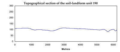
Soil/Landform Unit 190
Landform Unit Description
Page top
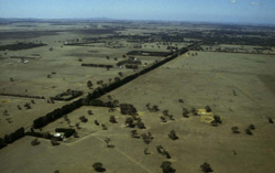 Undulating plains west of Bannockburn |
0.57% of CMA region This undulating plains and terrace unit within the sedimentary Western Plains. This unit occurs in the Bannockburn, Mount Moriac, Buckley and Paraparap areas and predominantly consists of a Neogene plain (plateau) but includes a terrace complex where dissected. This unit occurs as a ‘window’ amongst various basaltic landforms (mainly plains), with a dominant upper plain component and minor lower plain, drainage line and two terrace components. The soils are mottled brown texture contrast soils (Chromosols) on the upper plains and similar but sodic soils (Sodosols) on the lower plains and higher terraces. The lower terrace has dark gradational soils (Dermosols). The lighter surface soils are prone to nutrient decline and sheet and rill erosion as well as structure decline especially where soils are sodic. Waterlogging is also a possibility in the depressions, though rainfall decreases northward in terms of this unit. Land use is grazing, cropping, ferruginous gravel extraction on the Neogene plains, grazing on the upper terrace with some market gardening on the lower terrace. |  |
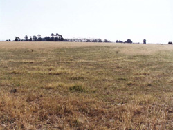 Near-level plain as part of window near Moriac | 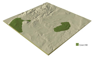 |
 | 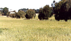 Cropping on these soils is a minor land use with grazing dominant |
Component | 1 | 2 | 3 | 4 | 5 | 6 |
Proportion of soil-landform unit | 70% | 9% | 8% | 1% | 5% | 7% |
| CLIMATE Rainfall (mm) | Annual: 500–680 | |||||
| Temperature (oC) | Minimum 9, Maximum 19 | |||||
| Precipitation less than potential evapotranspiration | October–April | |||||
| GEOLOGY Age and lithology | ||||||
| Geomorphology | ||||||
| LANDUSE | Uncleared: Nature conservation Cleared: Cropping (cereal); sheep and beef cattle grazing; low quality plantations; ironstone gravel extraction; regional development; market gardens (on lower areas) | |||||
| TOPOGRAPHY Landscape | Undulating plains and terraces | |||||
| Elevation range (m) | 27–293 | |||||
| Local relief (m) | 3–8 | |||||
| Drainage pattern | Dendritic | - | ||||
| Drainage density (km/km2) | 0.7 | 5.7 | ||||
| Landform | Undulating plain | Terrace | ||||
| Landform element | Upper plain | Drainage line | Lower plain | Sandridge with ferricrete | Higher terrace | Middle terrace |
| Slope and range (%) | 3 (2–5) | 1 (1–2) | 3 (1–5) | 4 (3–5) | 2 (1–5) | 1 (0–2) |
| Slope shape | Straight | Concave | Straight | Convex | Straight | Straight |
| NATIVE VEGETATION Ecological Vegetation Class | Woodland to open forest | Woodland to open forest | Woodland to open forest | Woodland to open forest | Woodland | |
| Dominant species | E. leucoxylon, Acacia pyncnantha, E. melidora, Casurina stricta, E. viminalis | E. camaldulensis | E. leucoxylon, Acacia spp | E. viminalis, A. .pyncnantha | E. viminalis E. radiata | |
| SOIL Parent material | Unconsolidated clay, silt, sand and gravel | Unconsolidated sediments and recent alluvial deposition | Unconsolidated clay, silt, sand and gravel | Unconsolidated sediments and ferricrete | Unconsolidated river deposits | Unconsolidated river deposits |
| Description (Corangamite Soil Group) | Mottled brown, grey or yellow texture contrast and red texture contrast soils, both finely structured (13) | Mottled brown, grey or yellow texture contrast soils, fine structure (13) | Mottled brown, grey or yellow sodic texture contrast soils, coarse structure (14) | Mottled brown, grey or yellow texture contrast soils (32) | Dark clay soils, variable texture-mainly clay loams (34) | |
| Soil type sites | ||||||
| Surface texture | Fine sandy loam | Sandy loam | Sandy loam | Fine sandy loam | Clay loam | Clay loam |
| Permeability | Moderate | Moderate to low | Low | High | Moderate to low | Moderate to low |
| Depth (m) | 1–2 | 1.5–2.5 | 2 | 0.7–1.8 | 1.2–2 | 1.2–2 |
| LAND CHARACTERISTICS, POTENTIAL AND LIMITATIONS | Hardsetting surfaces with overland flow and minor sheet erosion. | Seasonal high watertables combined with slope position result in periodic waterlogging and minor gully erosion. | Dispersibility of subsoils when exposed leads to moderate gully erosion. Overland flow and subsurface flow occur. | Hardsetting surfaces result in overland flow and minor sheet erosion. | Hardsetting surfaces result in overland flow and minor sheet erosion. | Low-lying areas prone to flooding, overland flow, periodic waterlogging and siltation. |
© State of Victoria (Agriculture Victoria) 1996 - .

This work, Victorian Resources Online, is licensed under a Creative Commons Attribution 4.0 licence. You are free to re-use the work under that licence, on the condition that you credit the State of Victoria (Agriculture Victoria) as author, indicate if changes were made and comply with the other licence terms.
The licence does not apply to ‘branding’ or some ‘images or photographs’ that may be owned by third parties. We ask you to seek prior approval to use images using the VRO feedback form. Access to higher quality images can also be provided on request.
This page was last updated on .