
Soil/Landform Unit 187
Landform Unit Description
Page top
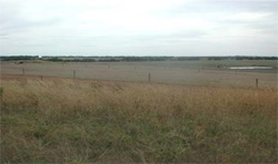
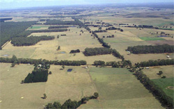 Gently undulating rises south-west of Irrewillipe support a wide range of land uses including softwood and hardwood plantations |
0.29% of CMA region Gently undulating rises on sedimentary origin occur between Irrewillipe and Simpson. These rises comprise a variety of vegetation classes including Lowland Forest and Herb-rich Foothill Forest. The gentle slopes have low nutrient and water holding capacities in the subsurface and subsoil. Heavy, possibly expansive clay subsoil is often massively structured, therefore indicating very low soil permeabilities. The forests have historically provided sawn timber, posts and firewood and is still used for softwood plantations. Dairy farming in this area is the prominent land use due to the sufficiently high annual rainfall (950 mm). Soils include acidic mottled duplex soils with massive and structured subsoils. Sandy mottled duplex soils with massive and structured subsoils may also occur. |  |
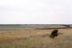 Red soils of the dam bank are indicative of the ferruginised nature of crests and upper slopes | 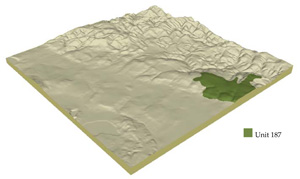 |
 |  Gentle slopes of the sedimentary rises has hardsetting duplex soils that are prone to sheet and rill erosion |
Component | 1 | 2 | 3 | 4 |
Proportion of soil-landform unit | 50% | 36% | 12% | 2% |
| CLIMATE Rainfall (mm) | Annual: 950 | |||
| Temperature (oC) | Minimum 8 , Maximum 18 | |||
| Precipitation less than potential evapotranspiration | November–March | |||
| GEOLOGY Age and lithology | Neogene fluvio-marine sand, silt and clay | |||
| Geomorphology | ||||
| LANDUSE | Uncleared: Hardwood forestry for sawlogs, posts and poles; softwood plantations; nature conservation; water supply Cleared: Dairy farming; beef cattle and sheep grazing; water supply; softwood plantation | |||
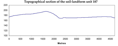
| TOPOGRAPHY Landscape | Gently undulating rises | |||
| Elevation range (m) | 126–202 | |||
| Local relief (m) | 30 | |||
| Drainage pattern | Dendritic | |||
| Drainage density (km/km2) | 1.2 | |||
| Landform | Rises | Drainage depressions | ||
| Landform element | Broad low crests and upper slopes | Mid slopes | Lower slopes | |
| Slope and range (%) | 4 (1–12) | 2 (1–5) | 3 (1–6) | 4 (0–7) |
| Slope shape | Convex | Straight | Concave | Concave |
| NATIVE VEGETATION Ecological Vegetation Class | Lowland Forest (14.9%), Herb-rich Foothill Forest (3.2%) | |||
| SOIL Parent material | Sand, silt and clay | Sand, silt and clay | Sand, silt and clay | Colluvium and alluvium; sand, silt and clay |
| Description (Corangamite Soil Group) | Acidic, mottled yellow texture contrast soils (13) | Acidic, mottled yellow texture contrast soils (13) | Acidic, mottled yellow texture contrast soils (13) | |
| Soil type sites | ||||
| Surface texture | Fine sandy loam | Fine sandy loam | Fine sandy loam | Fine sandy loam |
| Permeability | Moderate | Moderate | Moderate to low | Low |
| Depth (m) | <2 | <2 | <2 | <2 |
| LAND CHARACTERISTICS, POTENTIAL AND LIMITATIONS | Large texture contrast, low nutrient holding capacity and water holding capacity in subsurface and surface soil, higher in subsoil. Acidic (not quite strongly). Heavy, possibly expansive clay subsoil. Moderately rapid site drainage. | Large texture contrast, low nutrient holding capacity and water holding capacity in subsurface and surface soil, higher in subsoil. Acidic (not quite strongly). Heavy, possibly expansive clay subsoil. Moderately rapid site drainage. | Large texture contrast, low nutrient holding capacity and water holding capacity in subsurface and surface soil, higher in subsoil. Acidic (not quite strongly). Heavy, possibly expansive clay subsoil. Slow site drainage, higher susceptibility to waterlogging and compaction compared with Component 1. | Texture contrast, low nutrient holding capacity and water holding capacity in subsurface and surface soil, higher in subsoil. Acidic (not quite strongly). Heavy, possibly expansive clay subsoil. Slow site drainage, susceptibility to waterlogging and compaction. |
© State of Victoria (Agriculture Victoria) 1996 - .

This work, Victorian Resources Online, is licensed under a Creative Commons Attribution 4.0 licence. You are free to re-use the work under that licence, on the condition that you credit the State of Victoria (Agriculture Victoria) as author, indicate if changes were made and comply with the other licence terms.
The licence does not apply to ‘branding’ or some ‘images or photographs’ that may be owned by third parties. We ask you to seek prior approval to use images using the VRO feedback form. Access to higher quality images can also be provided on request.
This page was last updated on .