
Soil/Landform Unit 182
Landform Unit Description
Page top
 Level plain with remnant red gum and swamp gum |
0.24% of CMA region The level plains south of Shelford are characterised by the plateau remnants. The level plain is bound by steep slopes and scarps along the Leigh River to the west. Dissection has developed the topographically significant entrenched valley and valley floor of the Leigh River where a host of geologies are exposed. The dominant soil has a sandy loam surface layer and a mottled yellow or red subsoil clay that overlies unconsolidated clay. Occasionally isolated ferricrete layers occur at the top of the subsoil or further down in the profile. These texture contrast soils occur with grey or brown clays found on the minor flats and drainage depressions. The vegetation classes include plains grassy woodland and grassy woodland with Eucalyptus camaldulensis dominant as scattered trees. The main land use is grazing and cereal cropping, areas remain timbered and are used for recreation, sand and gravel extraction and low quality forestry. Erosion hazards are minimal except at scarps, which have a moderate susceptibility to soil loss. Soils are prone to waterlogging due to poor site drainage and compaction is a problem on the flatter gilgaied areas. | 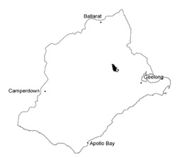 |
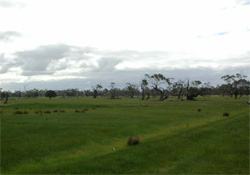 Drainage lines have been constructed to assist with surface run off | 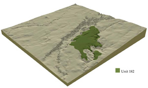 |
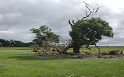
 | 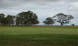 Remnant vegetation consists of red gum, yellow gum and swamp gum |
Component | 1 | 2 | 3 | 4 |
Proportion of soil-landform unit | 80% | 10% | 9% | 1% |
| CLIMATE Rainfall (mm) | Annual: 580 | |||
| Temperature (oC) | Minimum 9, Maximum 19 | |||
| Precipitation less than potential evapotranspiration | October–April | |||
| GEOLOGY Age and lithology | Neogene unconsolidated marine sand, clay and silt | |||
| Geomorphology | ||||
| LANDUSE | Uncleared: Nature conservation Cleared: Sheep and beef cattle grazing; cropping (cereal) | |||
| TOPOGRAPHY Landscape | Undulating to flat plains | |||
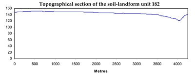
| Elevation range (m) | 27–206 | |||
| Local relief (m) | 3 | |||
| Drainage pattern | Dendritic | |||
| Drainage density (km/km2) | 1.8 | |||
| Landform | Undulating plains | |||
| Landform element | Upper plain | Drainage line | Lower plain | Sand ridge with ferricrete |
| Slope and range (%) | 2 (2–5) | 1 (1–2) | 2 (1–5) | 4 (3–5) |
| Slope shape | Straight | Concave | Straight | Convex |
| NATIVE VEGETATION Ecological Vegetation Class | Plains Grassy Woodland (0.9%), Grassy Woodland (0.8%) | |||
| Dominant species | E. camaldulensis, E. ovata | E. camaldulensis, E. ovata | E. leucoxylon, Acacia spp. | E. viminalis, Acacia pycnantha |
| SOIL Parent material | Unconsolidated clay, silt, sand and gravel | Unconsolidated sediments and recent alluvial deposits | Unconsolidated clay, silt, sand and gravel | Unconsolidated sediments and ferricrete |
| Description (Corangamite Soil Group) | Mottled brown, grey, yellow and red texture contrast soils, both fine structured (13) | Mottled brown, grey or yellow texture contrast soils, fine structure (13) | Mottled brown, grey or yellow sodic soils, coarse structure (14) | |
| Soil type sites | ||||
| Surface texture | Fine sandy loam | Sandy loam | Sandy loam | Fine sandy loam |
| Permeability | Moderate | Moderate to low | Low | High |
| Depth (m) | 1.0–2.0 | 1.5–2.5 | 2 | 0.7–1.8 |
| LAND CHARACTERISTICS, POTENTIAL AND LIMITATIONS | Hardsetting surfaces and low permeability leads to overland flow. This flow often causes minor sheet and rill erosion with major rainfall events. | Seasonal high watertables, overland flow, periodic waterlogging and minor gully erosion are degradation concerns. | Dispersible subsoils, overland flow, subsurface flow and minor gully erosion are degradation concerns. | Hardsetting surfaces and low permeability leads to overland flow. This flow often causes minor sheet and rill erosion with major rainfall events. |
© State of Victoria (Agriculture Victoria) 1996 - .

This work, Victorian Resources Online, is licensed under a Creative Commons Attribution 4.0 licence. You are free to re-use the work under that licence, on the condition that you credit the State of Victoria (Agriculture Victoria) as author, indicate if changes were made and comply with the other licence terms.
The licence does not apply to ‘branding’ or some ‘images or photographs’ that may be owned by third parties. We ask you to seek prior approval to use images using the VRO feedback form. Access to higher quality images can also be provided on request.
This page was last updated on .