
Soil/Landform Unit 180
Landform Unit Description
Page top
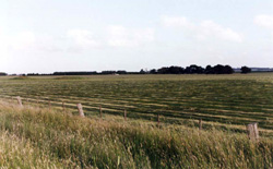 Productive undulating plains used for seed and pasture production |
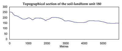
0.61% of CMA region Lying between the basalt plains to the north and dissected ferruginised landscapes to the south, much, if not all, of this flat plain apparently marks the eastern extent of a large former lake in western Victoria. The landscape slopes very gently to the east with increasing dissection as the height above the Barwon River floodplain increases from 10 m to about 40 m. The lacustrine deposits appear to be mainly calcareous and have formed soils with alkaline reaction trends. Dissolution of calcium carbonate has led to the development of sink holes in some areas, although levelling of paddocks has made these less apparent. The native vegetation has been almost completely removed for agricultural use and its original structure and composition are difficult to determine. In the east there is some evidence of a former woodland, but further west the soils are less well drained and possibly the communities were more stunted. |  |
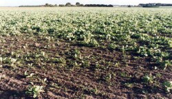
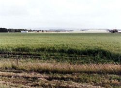 Maize crop grown for seed production east of Birregurra |  |
 |  Summer fodder crop |
Component | 1 | 2 | 3 |
Proportion of soil-landform unit | 80% | 10% | 10% |
| CLIMATE Rainfall (mm) | Annual: 600–650, lowest January (30), highest February (75) | ||
| Temperature (oC) | Annual: 13, lowest July (8), highest February (19) | ||
| Precipitation less than potential evapotranspiration | Temperature: less than 10oC (av.) June–August Precipitation: less than potential evapotranspiration October–late April | ||
| GEOLOGY Age and lithology | Neogene marine marl and calcarenite, and fluvio-marine sand; Recent clay, sand and gravel; Paleogene fluvial sand; minor Quaternary basalt | ||
| Geomorphology | |||
| LANDUSE | Uncleared: Nature conservation; water supply Cleared: Sheep and beef cattle grazing; dairy farming; cropping | ||
| TOPOGRAPHY Landscape | Flat plain bordering the present floodplain of the Barwon river | ||
| Elevation range (m) | 110–130 | ||
| Local relief (m) | 10 | ||
| Drainage pattern | Dendritic | ||
| Drainage density (km/km2) | 1.1 | ||
| Landform | Flat plains | ||
| Landform element | Flat plain | Sinkhole | Younger terrace |
| Slope and range (%) | 1 (0–3) | 0 (0–1) | 2 (1–3) |
| Slope shape | Linear | Concave | Linear |
| NATIVE VEGETATION Structure | Woodland | Sedgeland | Woodland |
| Dominant Species | E. viminalis, E. ovata | Carex spp. Scirpus calocarpus, Schoenus apogon, Juncus spp, Ranunculus spp. | E. ovata, E. camaldulensis |
| SOIL Parent material | Calcareous clay | Calcareous clay, plant remains | Alluvial clay, silt |
| Description (Corangamite Soil Group) | Yellow-brown calcareous texture contrast soils, coarse structure (33) | Grey gradational soils (34) | |
| Soil type sites | OTR733 | ||
| Surface texture | Fine sandy loam | Clay | Clay loam |
| Permeability | Very low | Very low | Very low |
| Depth (m) | >2 | >2 | >2 |
| LAND CHARACTERISTICS, POTENTIAL AND LIMITATIONS | Dispersible clay subsoils of low permeability are prone to gully and tunnel erosion. Seasonally high watertables lead to soil salting. | High watertables and low permeability lead to waterlogging, soil compaction and soil salting. | High seasonal watertables, low permeability and saline ground water lead to waterlogging, soil compaction and soil salting. |
© State of Victoria (Agriculture Victoria) 1996 - .

This work, Victorian Resources Online, is licensed under a Creative Commons Attribution 4.0 licence. You are free to re-use the work under that licence, on the condition that you credit the State of Victoria (Agriculture Victoria) as author, indicate if changes were made and comply with the other licence terms.
The licence does not apply to ‘branding’ or some ‘images or photographs’ that may be owned by third parties. We ask you to seek prior approval to use images using the VRO feedback form. Access to higher quality images can also be provided on request.
This page was last updated on .