
Soil/Landform Unit 172
Landform Unit Description
Page top
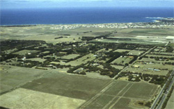 Robinson et al. (2003) Corangamite Land Resource Assessment. DPI Victoria Gently undulating sedimentary plains of a remnant plateau located north-east of Torquay |
0.74% of CMA region These gently undulating plains occur as envelopes of Neogene fluvio-marine sand overlying various geologies in a number of areas across the region including Bannockburn, Torquay, Gheringhap, Maude and Lismore. These sedimentary plains of the dissected Western Plains support a wide range of vegetation classes including Plains Grassy Woodland, Plains Grassland/Plains Grassy Woodland Mosaic and Coastal Dune Scrub Mosaic. The dominant species vary from area to area along with the density and occurrence of vegetation classes. The low fertility and the low water holding capacity of the soils is an inherent limitation. Soils include an association of bleached brown, grey, yellow and/or red sandy mottled texture contrast soils or unbleached equivalents in better drained areas. Heavier surface textured soils may occur in drainage lines. These soils are prone to gully erosion which is minor to moderate in severity in some cleared areas along with sheet and rill erosion and waterlogging in wet seasons. |  |
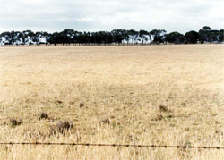 The gently undulating plains have been extensively cleared and now support mainly grazing | 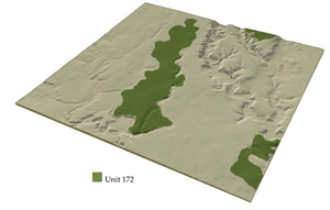 |
 | 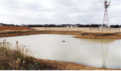 Red highly ferruginised texture contrast soils exposed in a dam east of Torquay |
Component | 1 | 2 | 3 | 4 |
Proportion of soil-landform unit | 60% | 8% | 7% | 25% |
| CLIMATE Rainfall (mm) | Annual: 580 | |||
| Temperature (oC) | Minimum 9, Maximum 19 | |||
| Precipitation less than potential evapotranspiration | October–April | |||
| GEOLOGY Age and lithology | Neogene fluvial sand and minor marine marl, Quaternary basalt, Devonian granite | |||
| Geomorphology | ||||
| LANDUSE | Uncleared: Nature conservation; hardwood; gravel extraction Cleared: Sheep and beef cattle grazing; cropping (cereal); gravel extraction | |||
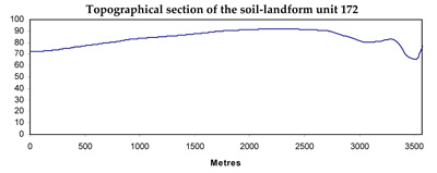
| TOPOGRAPHY Landscape | Gently undulating sedimentary plains | |||
| Elevation range (m) | 8–253 | |||
| Local relief (m) | 3 | |||
| Drainage pattern | Dendritic | |||
| Drainage density (km/km2) | 0.8 | |||
| Landform | Undulating plains | |||
| Landform element | Upper plain | Drainage line | Lower plain | Long gentle upper slopes |
| Slope and range (%) | 3 (2–5) | 1 (1–2) | 3 (1–5) | 1 (1–3) |
| Slope shape | Straight | Concave | Straight | Straight |
| NATIVE VEGETATION Ecological Vegetation Class | Plains Grassy Woodland (3.9%), Plains Grassland / Plains Grassy Woodland Mosaic (0.6%), Coastal Dune Scrub Mosaic (0.3%) | |||
| Dominant species | E. leucoxylon, Acacia pycnantha, E. melliodora, Casurina stricta, E. viminalis | E. camaldulensis | E. leucoxylon, Acacia spp. | E. ovata, E viminalis, E. rubida, E. obliqua |
| SOIL Parent material | Unconsolidated clay, silt, sand and gravel | Unconsolidated sediments and recent alluvial deposits | Unconsolidated clay, silt, sand and gravel | In situ weathered basalt |
| Description (Corangamite Soil Group) | Mottled brown, grey or yellow and red texture contrast soils, both fine structured (13) | Mottled brown, grey or yellow texture contrast soils, fine structure (13) | Mottled brown, grey or yellow sodic soils, coarse structure (14) | |
| Soil type sites | ||||
| Surface texture | Fine sandy loam | Sandy loam | Sandy loam | Clay loam |
| Permeability | Moderate | Moderate to low | Low | Moderate to low |
| Depth (m) | 1.0–2.0 | 1.5–2.5 | 2 | 1.5 |
| LAND CHARACTERISTICS, POTENTIAL AND LIMITATIONS | Hardsetting surfaces and overland flow combine to create minor sheet erosion. | Seasonal high watertables, slope position and overland flow lead to periodic waterlogging and minor gully erosion. | Hardsetting surfaces and overland flow combine to create moderate gully erosion. | Hardsetting surfaces, dispersible subsoils and overland flow result in, leaching of salts, surface compaction, sheet and rill erosion and gully erosion. |
© State of Victoria (Agriculture Victoria) 1996 - .

This work, Victorian Resources Online, is licensed under a Creative Commons Attribution 4.0 licence. You are free to re-use the work under that licence, on the condition that you credit the State of Victoria (Agriculture Victoria) as author, indicate if changes were made and comply with the other licence terms.
The licence does not apply to ‘branding’ or some ‘images or photographs’ that may be owned by third parties. We ask you to seek prior approval to use images using the VRO feedback form. Access to higher quality images can also be provided on request.
This page was last updated on .