
Soil/Landform Unit 166
Landform Unit Description
Page top
 The entrenched valley slopes and alluvial floor of the Curdies River |
1.11% of CMA region Dissection of lava plains and Neogene sediments in the south-west of the Western Plains of Corangamite has lead to the development of a steeply dissected entrenched valley with a broad alluvial floor. This unique landscape includes the Curdies River and minor contributing streams. The entrenched valley and valley floor includes Herb-rich Foothill Forest, Riparian Forest and Lowland Forest as the major vegetation classes. This dissection has produced steeply dissected terrain highlighting a wide diversity of geologies (Neogene marl, limestone, sands and gravels, and Quaternary volcanics and alluvium) in these steep slopes and scarps. The unit consists of black cracking clays on the alluvial plains. On the steep slopes of the entrenched valley, acidic mottled texture contrast soils, shallow brown clays and black and grey cracking clays are dominant. On the upper slopes and crests black texture contrast soils and acidic mottled texture contrast soils occur. Land use includes water supply, grazing, cropping, horticulture and nature conservation. Erosion hazards are high on the scarps and steep slopes, which have a high susceptibility to soil loss. Landslip and rock falls are also hazards of this steep terrain. Areas with shallow stony gradational soils are susceptible to leaching of nutrients, and compaction is a problem on the alluvial plains. | 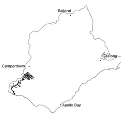 |
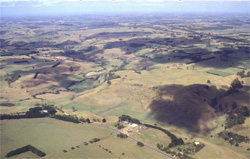
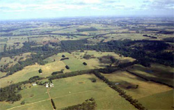
 Major dissection of the remnant plain has left slopes that drain into stream south of Cobden |  |
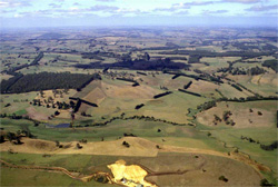
 |  Drainage line of the Heytesbury with prominent vegetation lining the stream banks |
Component | 1 | 2 | 3 |
Proportion of soil-landform unit | 10% | 60% | 30% |
| CLIMATE Rainfall (mm) | Annual: 850 | ||
| Temperature (oC) | Minimum 9, Maximum 19 | ||
| Precipitation less than potential evapotranspiration | October-March | ||
| GEOLOGY Age and lithology | Neogene fluvial-marine sediments, minor marl, calcarenite and Quaternary basalt | ||
| Geomorphology | |||
| LANDUSE | Uncleared: Nature conservation; passive recreation; water supply Cleared: Dairy farming; beef cattle and sheep grazing; cropping; water supply (stock); passive recreation | ||
| TOPOGRAPHY Landscape | Undulating alluvial plains and valley slopes | ||
| Elevation range (m) | 1-169 | ||
| Local relief (m) | 40 | ||
| Drainage pattern | Rectangular-parallel | ||
| Drainage density (km/km2) | 2.8 | ||
| Landform | Entrenched alluvial valleys | ||
| Landform element | Rise and crest | Side slopes | Drainage channel |
| Slope and range (%) | 4 (1-7) | 8 (5-15) | 1 (0-3) |
| Slope shape | Convex | Convex | Concave |
| NATIVE VEGETATION Ecological Vegetation Class | Herb-rich Foothill Forest (6.1%); Riparian Forest (2.6%); Lowland Forest (1.1%) | ||
| SOIL Parent material | In situ rock/sediments, colluvium; sand, silt and clay. | Colluvium and alluvium; clay, silt and sand | Alluvium; clay, silt and sand |
| Description (Corangamite Soil Group) | Black cracking clays (31) | ||
| Soil type sites | |||
| Surface texture | Fine sandy loam | Fine sandy loam, light clay | Medium clay |
| Permeability | Moderate | Moderate to low | Low |
| Depth (m) | <2 | <1.5 | >2 |
| LAND CHARACTERISTICS, POTENTIAL AND LIMITATIONS | Texture contrast with surface soils having low to moderate water holding capacity and nutrient holding capacity, higher in subsoil. Moderately rapid site drainage, surface soils have moderate susceptibility to sheet and rill erosion and nutrient decline. Variable soils and soil depth mean variable susceptibles. Subsoils may have expansive clays. | Texture contrast surface soils have low to moderate water holding capacity and nutrient holding capacity, higher in subsoil. Rapid site drainage, slope and topographical position mean surface soils susceptible to sheet and rill erosion and nutrient decline. Variable soils and soil depth mean variable susceptibilities. | Heavy expansive clays, permeable when dry, very poor permeability when wet and susceptible to compaction. High nutrient holding capacity. Very poor to poor site drainage. |
© State of Victoria (Agriculture Victoria) 1996 - .

This work, Victorian Resources Online, is licensed under a Creative Commons Attribution 4.0 licence. You are free to re-use the work under that licence, on the condition that you credit the State of Victoria (Agriculture Victoria) as author, indicate if changes were made and comply with the other licence terms.
The licence does not apply to ‘branding’ or some ‘images or photographs’ that may be owned by third parties. We ask you to seek prior approval to use images using the VRO feedback form. Access to higher quality images can also be provided on request.
This page was last updated on .