
Soil/Landform Unit 163
Landform Unit Description
Page top
 Around Cobden the occurrent of Port Campbell Limestone makes these broad crests sought after as a lime source |
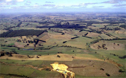
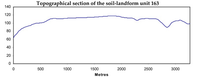
0.08% of CMA region The gently undulating ridge crests near Timboon are characterised by broad sandy cappings with Herb-rich Foothill Forests including species of stringybark and messmate. This sedimentary unit of the Western Plains is located north of Scotts Creek in the Heytesbury area, and is deeply dissected to the north and west by the Curdies River (and associated streams) and other Neogene sediments (marl and limestone) to the east. This area is a major area of dissection of Neogene sediments. Unit components are rise crests and upper slopes, and lower slopes on the rises, and drainage lines. The soils are acidic mottled brown texture contrast soils (Chromosols). Susceptibility to waterlogging occurs in the depressions but given the higher rainfall of the area and light surface soils, susceptibility to nutrient decline is high. Slight susceptibility to sheet erosion occurs on the slopes. Land use is intensive grazing (dairying) and some cropping. | 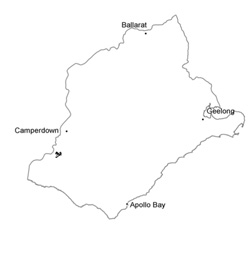 |
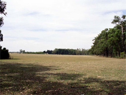 Near-level top of these broad crests | 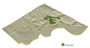 |
 | 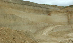 Miocene limestone underlying Neogene sediments at a quarry in the Curdies River |
Component | 1 | 2 | 3 |
Proportion of soil-landform unit | 50% | 42% | 8% |
| CLIMATE Rainfall (mm) | Annual: 840 | ||
| Temperature (oC) | Minimum 9, Maximum 19 | ||
| Precipitation less than potential evapotranspiration | October-March | ||
| GEOLOGY Age and lithology | Nepgeme fluvial_marine sediments, Recent clay, sand and gravel | ||
| Geomorphology | |||
| LANDUSE | Uncleared areas: Hardwood forestry for sawlogs, posts and poles; water supply, nature conservation Cleared areas: Intensive grazing (dairying), some cropping | ||
| TOPOGRAPHY Landscape | Gently undulating ridge crests | ||
| Elevation range (m) | 60-152 | ||
| Local relief (m) | 30 | ||
| Drainage pattern | Rectangular-pinnate | ||
| Drainage density (km/km2) | 0.7 | ||
| Landform | Rises | Drainage lines | |
| Landform element | Ridge crests and upper slopes | Lower slopes | |
| Slope and range (%) | 5 (3-10) | 3 (2-6) | 2 (1-4) |
| Slope shape | Convex | Concave | Concave |
| NATIVE VEGETATION Ecological Vegetation Class | Herb-rich Foothill Forest (20.8%) | ||
| SOIL Parent material | Sand, silt and clay | Sand, silt and clay | Clay, silt and sand |
| Description (Corangamite Soil Group) | Acidic mottled brown texture contrast soils (13) | Acidic mottled brown texture contrast soils (13) | Acidic mottled brown texture contrast soils (13) |
| Soil type sites | |||
| Surface texture | Fine sandy loam to clay loam | Fine sandy loam to clay loam | Fine sandy loam |
| Permeability | Low to moderate | Low | Very low |
| Depth (m) | <2 | <2 | >2 |
| LAND CHARACTERISTICS, POTENTIAL AND LIMITATIONS | Large texture contrast, low nutrient holding capacity and water holding capacity in subsurface and surface soil, higher in subsoil. Acidic (not quite strongly). Heavy, possibly expansive clay subsoil, occasionall sodic. Moderately rapid site drainage. | Large texture contrast, low nutrient holding capacity and water holding capacity in subsurface and surface soil, higher in subsoil. Acidic (not quite strongly). Heavy, possibly expansive clay subsoil, occasionally sodic. Moderate site drainage. | Large texture contrast, low nutrient holding capacity and water holding capacity in subsurface and surface soil, higher in subsoil. Acidic (not quite strongly). Heavy, possibly expansive clay subsoil, occasionally sodic. Slow to moderate site drainage. |
© State of Victoria (Agriculture Victoria) 1996 - .

This work, Victorian Resources Online, is licensed under a Creative Commons Attribution 4.0 licence. You are free to re-use the work under that licence, on the condition that you credit the State of Victoria (Agriculture Victoria) as author, indicate if changes were made and comply with the other licence terms.
The licence does not apply to ‘branding’ or some ‘images or photographs’ that may be owned by third parties. We ask you to seek prior approval to use images using the VRO feedback form. Access to higher quality images can also be provided on request.
This page was last updated on .