
Soil/Landform Unit 158
Landform Unit Description
Page top
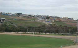
 Regional development in the towns of Jan Juc and Torquay is a major land use on slopes on the rolling hills |
0.13% of CMA region Below the ferruginised plateau to the east of the Otway Range lie a series of rolling hills that have formed by dissection along the valleys of Spring Creek and Jan Juc Creek. Weathering of limestone and marl exposed along these valleys has resulted in calcareous soils. Fertility is moderate, and thus contrasts with the surrounding impoverished soils of the ferruginised plateau and acid sands and clays. The red soils, or those deeper profiles transitional to the red soils, are the most favoured for agriculture and are used for cropping as well as dairy farming. Grazing of sheep and beef cattle is also common. Agricultural use is decreasing, however, as the township of Torquay extends its urban limits. Subdivision into small farmlets in other parts of the valleys also tends to decrease agricultural production. Sheet erosion occurs on some of the cropped steeper slopes, while gully erosion and slumping are problems of the dispersible texture contrast soils. |  |
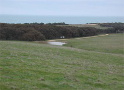
 Rolling hill slopes at Jan Juc | 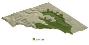 |
 | 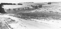 Wide drainage lines and rounded hills typify this landscape, as it rises to the ferruginised plateau in the distance |
Component | 1 | 2 | 3 | 4 |
Proportion of soil-landform unit | 25% | 40% | 20% | 15% |
| CLIMATE Rainfall (mm) | Annual: 600-650, lowest January (30), highest August (65) | |||
| Temperature (oC) | Annual: 14, lowest July (10), highest February (18) | |||
| Seasonal growth limitations | Temperature: less than 10oC (av.) July Precipitation: less than potential evapotranspiration early October - early April | |||
| GEOLOGY Age and lithology | Paleogene marine marl and limestone; Neogene fluvio-marine sand; minor Quaternary clay, sand and gravel | |||
| Geomorphology | ||||
| LANDUSE | Cleared areas: Dairy farming, beef cattle grazing; residential; cropping Minor uncleared areas: Forest grazing; active and passive recreation; hardwood forestry for fuel, posts and poles | |||
| TOPOGRAPHY Landscape | Rolling hills dissected out below the lateritic plateaux | |||
| Elevation range (m) | 5-70 | |||
| Local relief (m) | 60 | |||
| Drainage pattern | Dendritic | |||
| Drainage density (km/km2) | 2.7 | |||
| Landform | Hills | |||
| Landform element | Upper slope | Middle slope | Steeper slope | Lower slope and drainage line |
| Slope and range (%) | 5 (3-9) | 11 (5-14) | 15 (7-20) | 7 (1-9) |
| Slope shape | Linear | Linear | Convex | Concave |
| NATIVE VEGETATION Structure | Open forest | Open forest | Open forest | Open forest |
| Dominent species | E. viminalis, E sideroxylon, E. obliqua | E. leucoxylon, E. sideroxylon, E. viminalis | E. viminalis, E. ovata, Acacia melanoxylon | E. viminalis, E. sideroxylon, E. leucoxylon, E. ovata |
| SOIL Parent material | Truncated ferricrete remnants | Calcareous clay and deeply weathered limestone | Limestone | Colluvial limestone, clay, ferruginised material |
| Description (Corangamite Soil Group) | Yellow-brown calcareous sodic texture contrast soils, coarse structure (19) | Red calcareous gradational soils (24) | ||
| Soil type sites | OTR783, OTR490 | |||
| Surface texture | Fine sandy loam | Fine sandy loam | Fine sandy clay loam | Loamy sand |
| Permeability | Low | Moderate | High | Moderate |
| Depth (m) | >2 | >2 | 0.7 | >2 |
| LAND CHARACTERISTICS, POTENTIAL AND LIMITATIONS | Dispersible subsoils receiving seepage water are prone to gully erosion, slumping and rilling. | Highly dispersible subsoils are prone to gully erosion and slumping. | Steeper slopes are prone to sheet erosion. | High dispersible subsoils are prone to gully erosion and tunnel erosion. |
© State of Victoria (Agriculture Victoria) 1996 - .

This work, Victorian Resources Online, is licensed under a Creative Commons Attribution 4.0 licence. You are free to re-use the work under that licence, on the condition that you credit the State of Victoria (Agriculture Victoria) as author, indicate if changes were made and comply with the other licence terms.
The licence does not apply to ‘branding’ or some ‘images or photographs’ that may be owned by third parties. We ask you to seek prior approval to use images using the VRO feedback form. Access to higher quality images can also be provided on request.
This page was last updated on .