
Soil/Landform Unit 121
Landform Unit Description
Page top
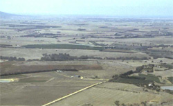 Looking north over the vast broad plains. There is considerable variation of soils and landforms within this large unit |
1.25% of CMA region The undulating rises with broad areas of near level plains extend from Anakie to Geelong. These areas are volcanic in origin and have shallow regolith development for basalts across the Western Plains. The thin soils support grazing and minor cropping with an average annual rainfall of 540 mm. Vegetation is limited to Plains Grassland. The co-dominant soils of the rises, which have variable amounts of surface stone, are alkaline mottled black texture contrast soils. There are minor occurrences of neutral, friable brown gradational soils, particularly on the rises with many surface stones, and alkaline mottled brown and mottled brown, grey or yellow texture contrast soils. On the level plains the co-dominant soils are also alkaline, mottled black texture contrast/cracking clay soils, with minor occurrences of alkaline red mottled brown and mottled yellow texture contrast soils. Alkaline grey cracking clays occur in depressions on the plain and shallow black cracking clays occur on the escarpment bordering Unit 119. The texture contrast soils have a moderate to high nutrient holding capacity in the topsoil, and moderate water holding capacity in deep topsoils. Well structured subsoils represent moderate to rapid site drainage. Soils are prone to sheet and rill erosion, and gully erosion where sodic subsoils are exposed. | 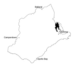 |
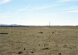 Land use is restricted to grazing across much of the unit due to the high frequency of surface stones | 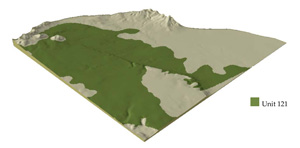 |
 | 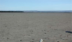 Broad plains with surface stones |
Component | 1 | 2 | 3 | 4 |
Proportion of soil-landform unit | 20% | 20% | 55% | 5% |
| CLIMATE Rainfall (mm) | Annual: 540 | |||
| Temperature (oC) | Minimum 9, Maximum 20 | |||
| Precipitation less than potential evapotranspiration | October-March | |||
| GEOLOGY Age and lithology | Quaternary basalt | |||
| Geomorphology | ||||
| LANDUSE | Uncleared: Nature conservation Cleared: Sheep and beef cattle grazing; cropping (cereal) | |||
| TOPOGRAPHY Landscape | Undulating rises and broad plains | |||
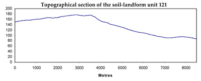
| Elevation range (m) | 11-220 | |||
| Local relief (m) | 2-3 | |||
| Drainage pattern | Dendritic | |||
| Drainage density (km/km2) | 0.8 | |||
| Landform | Gentle rises | Broad plains | Open depression/drainage line | |
| Landform element | Broad gentle crests and upper slopes | Lower slopes | Plains | |
| Slope and range (%) | 3 (1-7) | 2 (1-4) | 0 (0-1) | 3 (1-5) |
| Slope shape | Convex | Linear | Linear | Concave |
| NATIVE VEGETATION Ecological Vegetation Class | Plains Grassland (0.4%) | |||
| SOIL Parent material | In situ basalt | In situ basalt and colluvium | In situ basalt and colluvium | In situ basalt and colluvium |
| Description (Corangamite Soil Group) | ||||
| Soil type sites | SW99, SW97 | |||
| Surface texture | Fine sandy clay loam, clay loam | Fine sandy clay loam | Fine sandy clay loam | Fine sandy clay loam |
| Permeability | High to moderate | Moderate | Low to moderate | Very low |
| Depth (m) | <0.7 | <1.5 | <2 | >2 |
| LAND CHARACTERISTICS, POTENTIAL AND LIMITATIONS | Texture contrast and gradational. Stony. Moderate to high nutrient capacity in upper soil, high in subsoil. Low water holding capacity, shallow soil. Structured soil and moderately rapid site drainage, moderate to high permeability. Texture contrast soils are sodic, expansive clay subsoils. | Texture contrast, often stony. Moderate to high nutrient holding capacity in upper soil, high in subsoil. Moderate water holding capacity, moderately deep soil. Structured soil and moderately rapid site drainage, moderate permeability. Strongly sodic in subsoil, also expansive clays. | Texture contrast, often stony. Moderate to high nutrient holding capacity in upper soil, high in subsoil. Moderate water holding capacity, moderate deep soil. Structured soil and moderately rapid site drainage, moderate permeability. Strongly sodic in subsoil, also expansive clays. | Texture contrast or uniform, occasionally stony. Moderate to high nutrient holding capacity in upper soil, high in subsoil. Moderate to high water holding capacity, moderately deep to deep soil. Very low permeability. Strongly sodic in subsoil. Expansive clay soils, very slow site drainage. |
© State of Victoria (Agriculture Victoria) 1996 - .

This work, Victorian Resources Online, is licensed under a Creative Commons Attribution 4.0 licence. You are free to re-use the work under that licence, on the condition that you credit the State of Victoria (Agriculture Victoria) as author, indicate if changes were made and comply with the other licence terms.
The licence does not apply to ‘branding’ or some ‘images or photographs’ that may be owned by third parties. We ask you to seek prior approval to use images using the VRO feedback form. Access to higher quality images can also be provided on request.
This page was last updated on .