
SW100
|
| SW100 | 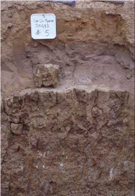 Calcic, Hypernatric, Brown SODOSOL | |
| Steiglitz road, north west of junction with Geelong-Ballan road | |||
| Gently undulating plain (basalt plain) | |||
| Neogene sediments (Moorabool Viaduct) and basalt alluvium | |||
| Drainage depression | |||
| 2% | |||
| South-west | |||
Horizon | Depth (cm) | Description | ||
Ap | 0-25 | Reddish yellow mottled; sand; hardsetting (recently deposited material); abrupt boundary to: | ||
A1b | 25-30 | Grey; loamy sand, buried A horizon clear boundary to: | ||
A2 | 30-55 | Greyish brown (10YR5/2 moist) conspicuously bleached (10YR7/1 dry) sand; massive structure; pH 6.4; sharp boundary to: | ||
B21t | 55-90 | Brown (10YR4/3 moist) medium clay; very coarse (>150 mm) prismatic structure parting to coarse polydedral peds; pH 8.2; gradual boundary to: | ||
B22t(k) | 90 + | Mottled brown and grey; clay loam; few (<5%) small calcium carbonate (CaCO3) accumulations at approximately 1.2 metres depth and concentrated around macropores; pH 9.5. | ||
| Management considerations | ||||
| ‘Spewy’ topsoil and sharp boundary to coarsely structured sodic clay subsoil render this soil very prone to waterlogging. The soil is situated at the upper end (initiation) of a drainage line carrying excess water from the basalt plain to the Moorabool River. This is highly erodible soil which should have permanent vegetation cover to protect river water quality. See also site SW99 for an associated soil type —these two sites are only 45 metres apart. | ||||
Analytical data
Site SW100 | Sample depth | pH | EC | NaCl | Ex Ca | Ex Mg | Ex K | Ex Na | Ex Al | Ex acidity | FC (-10kPa) | PWP (-150kPa) | KS | FS | Z | C | |
Horizon | cm | H2O | CaCl2 | dS/m | % | cmolc/kg | cmolc/kg | cmolc/kg | cmolc/kg | mg/kg | cmolc/kg | % | % | % | % | % | % |
A2 | 30-55 | 6.4 | 5.6 | 0.11 | N/R | 0.45 | 0.88 | 0.05 | 0.57 | N/R | 1.6 | N/R | N/R | 33.4 | 50.3 | 8.0 | 7.5 |
B21t | 55-90 | 8.2 | 7.0 | 0.3 | 0.02 | 4.9 | 7.5 | 0.7 | 8.9 | N/R | N/R | N/R | N/R | 16.5 | 26.7 | 6.5 | 45.5 |
B22 | 90+ | 9.5 | 8.5 | 0.52 | 0.05 | 4.7 | 703 | 0.6 | 7.7 | N/R | N/R | N/R | N/R | 18.5 | 34.5 | 10.0 | 33.0 |
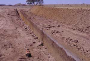
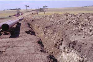 General view towards site SW100, basalt profiles in foreground trench. Note the change in colour of trench spoil across the drainage depression indicating the different provenance of soil parent material. |  Dissection of the plain by Moorabool River to the south-west. The bridge in the distance is the Moorabool Viaduct which lends its name to the geological formation underlying the basalt plain in the eastern portion of the Corangamite region. |
© State of Victoria (Agriculture Victoria) 1996 - .

This work, Victorian Resources Online, is licensed under a Creative Commons Attribution 4.0 licence. You are free to re-use the work under that licence, on the condition that you credit the State of Victoria (Agriculture Victoria) as author, indicate if changes were made and comply with the other licence terms.
The licence does not apply to ‘branding’ or some ‘images or photographs’ that may be owned by third parties. We ask you to seek prior approval to use images using the VRO feedback form. Access to higher quality images can also be provided on request.
This page was last updated on .