
CLRA12
|
| CLRA12 | 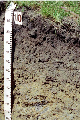 Melacic-mottled, Mesotrophic, Brown Dermosol | |
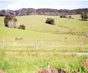
| Weeaproinah (Beech Forest Lavers Hill Road), Otway Ranges, south-west Victoria | |||
| Hills | |||
| Cretaceous sedimentary: Eumeralla Formation: fluvial, braided stream deposits, volcanolithic sandstone, siltstone, mudstone, with feldspar and quartz grains, fine to medium grained | |||
| Lower crest | |||
| 7–8% | |||
| South-east | |||
Horizon | Depth (cm) | Description | ||
A11 | 0–12 | Very dark greyish brown (10YR3/2) with common distinct dark reddish brown (5YR3/4) mottles due to bioturbation; very fine sandy clay loam; strong very fine to fine subangular blocky and polyhedral structure; rough ped fabric; very firm consistence (dry); non-calcareous, pH 5.75; abrupt smooth boundary to: | ||
A12 | 12–30 | Very dark grey (10YR3/1); fine sandy clay loam; strong very fine to fine subangular blocky and polyhedral structure; rough ped fabric; weak consistence (moist); non-calcareous, pH 5.5; clear smooth boundary to: | ||
B21 | 30–50 | Dark greyish brown and light grey (10YR4/3, 10YR7/4); light clay fine sandy; strong very fine to medium subangular blocky and polyhedral structure; rough ped fabric; weak consistence (moist); non-calcareous, pH 5.0; gradual smooth boundary to: | ||
B22 | 50–70 | Dark brown (10YR4/3) with common fine and medium distinct yellow (10YR7/6) mottles; fine sandy light clay; strong very fine to medium polyhedral structure; rough ped fabric; weak consistence (moist); non-calcareous, pH 5.0; gradual irregular boundary to: | ||
BC | 70–110+ | Bioturbated structure. | ||
| Management considerations | ||||
This soil is gradational with limited texture change with depth and gradational horizon boundaries. The strong fine structure contributes to the well drained drainage of the soils as evidenced by subsoil colour; the mottling at depth is more to do with substrate material. Other influences on drainage include rainfall, topographic position and soil depth; here on a low crest aiding drainage. The (medium) textures are ideal for many uses and soil stability indices indicate that the soil is very stable (Emerson class 8 for surface soil) and stable for the subsoil (Emerson class 5). The high organic matter content of the surface (12% OM) and the subsurface soil (10% OM) aids stability and friability, the combined depth providing a useful seedbed. The surface soil is slightly limited in depth. The lower pH in the soil will restrict the availability of some nutrients (less calcium) and increase the availability and mobility of aluminium, while the slightly higher surface pH is a result of management intervention to improve nutrient availability. This soil provides a good physical environment for plant growth but ideally would be deeper for water and nutrient storage. There is also the possibility that the current surface soil may have been transported due to initial clearing. | ||||
Site CLRA12 | Sample depth | pH | EC | NaCl | Ex Ca | Ex Mg | Ex K | Ex Na | Ex Al | Ex Acidity | FC –10kPa | PWP –1500kPa | KS | FS | Z | C | |
Horizon | cm | H2O | CaCl2 | dS/m | % | cmolc/kg | cmolc/kg | cmolc/kg | cmolc/kg | mg/kg | cmolc/kg | % | % | % | % | % | % |
A11 | 0–12 | 5.3 | 4.6 | 0.09 | N/R | 4.7 | 0.88 | 0.6 | 0.19 | 74 | 18 | 39.2 | 19.2 | 6.6 | 37.7 | 19 | 24.5 |
A12 | 15–25 | 5.1 | 4.3 | 0.06 | N/R | 2.7 | 0.48 | 0.5 | 0.15 | 230 | 22 | 38.2 | 16.4 | 4.1 | 37.2 | 24.5 | 24 |
B21 | 35–45 | 4.8 | 4.2 | 0.06 | N/R | 1.1 | 0.28 | 0.49 | 0.13 | 300 | 18 | 32.3 | 15.8 | 3.5 | 36.7 | 22.5 | 31.5 |
B22 | 55–65 | 4.8 | 4.2 | 0.06 | N/R | 1 | 0.26 | 0.51 | 0.11 | 340 | N/R | 32.8 | 15.9 | 23.9 | 54.1 | 5 | 16 |
© State of Victoria (Agriculture Victoria) 1996 - .

This work, Victorian Resources Online, is licensed under a Creative Commons Attribution 4.0 licence. You are free to re-use the work under that licence, on the condition that you credit the State of Victoria (Agriculture Victoria) as author, indicate if changes were made and comply with the other licence terms.
The licence does not apply to ‘branding’ or some ‘images or photographs’ that may be owned by third parties. We ask you to seek prior approval to use images using the VRO feedback form. Access to higher quality images can also be provided on request.
This page was last updated on .