
SW87
|
| SW87 | 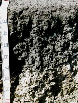 Epihypersodic-Endocalcareous, Self-Mulching, Black VERTOSOL | |
| Winchelsea, 2 km north west, near junction of Cressy and Shelford roads | |||
| Gently undulating plain/rises | |||
| Quaternary volcanics: basalt | |||
| Gentle simple slope | |||
| <1% | |||
| East | |||
Horizon | Depth (cm) | Description | ||
A1 | 0-15 | Very dark grey (10YR3/1 moist and 10YR4/1 dry); light medium clay; thin self-mulching surface; smooth-faced coarse blocky structure below surface; strong consistence, deep cracks to surface; pH 5.7; gradual boundary to: | ||
B21ss | 15-50/70 | Black (2.5Y2.5/1 moist, dry); heavy clay; strong, coarse (>100 mm) irregular lenticular structure, parting with difficulty to medium (>20 mm) lenticular peds, prominent slickensides increasing in size with depth; pH 8.0; clear and wavy boundary to: | ||
B22k | 50/70 + | White soft calcium carbonate (CaCO3) with fine olive brown (2.5Y4/3 moist) and dark yellowish brown (10YR4/6 moist) mottles in clay matrix; medium clay to light medium clay; pH 8.3. | ||
| Management considerations | ||||
| The very high wilting point (i.e. 28%) indicates that plants will be unable to fully utilise light rains, when the soil is dry. In moist to wet conditions, excessive tillage, trafficking or over stocking could result in structural damage (i.e. compaction, smearing). The subsoil has high shrink-swell properties, is dense, coarsely structured, strongly sodic and disperses strongly in water. These properties will restrict root growth and drainage when wet. When the soil is dry, heavy rains will run into soil cracks. There are engineering implications (e.g. disturbance to building foundations). | ||||
Analytical data
Site SW87 | Sample depth | pH | EC | NaCl | Ex Ca | Ex Mg | Ex K | Ex Na | Ex Al | Ex acidity | FC (-10kPa) | PWP (-150kPa) | KS | FS | Z | C | |
Horizon | cm | H2O | CaCl2 | dS/m | % | cmolc/kg | cmolc/kg | cmolc/kg | cmolc/kg | mg/kg | cmolc/kg | % | % | % | % | % | % |
A1 | 0-10 | 5.7 | 5 | 0.24 | N/R | 16 | 12 | 1.4 | 1.0 | <10 | 16 | 48.5 | 28.2 | 9.2 | 19.6 | 14 | 44 |
Bss | 35-55 | 8.0 | 7.3 | 0.76 | 0.15 | 15 | 15 | 0.8 | 5.5 | N/R | N/R | 54.0 | 25.6 | 4.8 | 19.4 | 15 | 55.5 |
Bk | 80-90 | 8.7 | 8.3 | 1.6 | 0.35 | 12 | 16 | 0.4 | 7.2 | N/R | N/R | 44.3 | 23.1 | 1.8 | 12.2 | 9.0 | 41 |
Soils in the local landscape associated with SW87 | |
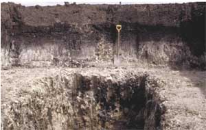 Excavation at the Cressy-Shelford road crossing shows highly calcareous subsoil to depth | 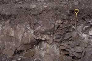 Excavation to the west of SW87 (very gentle rises) shows shallow soil over fractured rock |
© State of Victoria (Agriculture Victoria) 1996 - .

This work, Victorian Resources Online, is licensed under a Creative Commons Attribution 4.0 licence. You are free to re-use the work under that licence, on the condition that you credit the State of Victoria (Agriculture Victoria) as author, indicate if changes were made and comply with the other licence terms.
The licence does not apply to ‘branding’ or some ‘images or photographs’ that may be owned by third parties. We ask you to seek prior approval to use images using the VRO feedback form. Access to higher quality images can also be provided on request.
This page was last updated on .