
SW55
|
| SW55 | 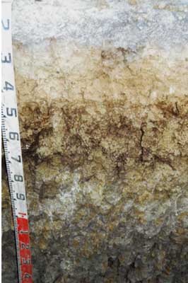 Melacic, Sesquic, Semiaquic PODOSOL (topsoil has been removed at this site) | |
| Cooriemungle road / Gallum road, tributary of Ross Creek, Heytesbury district | |||
| Valley floor | |||
| Transported Neogene Hanson Plain Sand and Gellibrand Marl | |||
| Crest of convex natural mound; remnant footslope or terrace. | |||
| 0 | |||
| NE | |||
Horizon | Depth (cm) | Description | ||
A1 | 0-8 | Black (10YR2/1 moist, 10YR4/1 dry); sandy loam; weak medium (5-20 mm) polyhedral structure; weak consistence; abrupt and smooth boundary to: | ||
A2 | 8-20 | Dark greyish brown (10YR4/2 moist), conspicuously bleached (10YR8/1 dry); fine sandy clay loam; apedal; massive; weak consistence; abrupt and wavy boundary to: | ||
B21s | 20-50 | Dark yellowish brown (10YR4/4 moist and 10YR6/8 dry); light sandy clay; massive; weak to firm consistence; clear and wavy boundary to: | ||
B22s(h) | 50-80 | Brownish yellow (10YR6/6) and brown (10YR4/3); very dark grey (7.5YR3/1 moist) on exterior of peds and in root channels; medium heavy clay; coarse (20-50 mm) polyhedral, parting to fine medium (10-15 mm) polyhedral structure; firm consistence: | ||
B23g | 80+ | Grey (10YR5/1), yellowish brown (10YR5/6 moist) and red (2.5YR5/8 moist) mottles common in interior of peds; dark grey to black coatings on ped faces and in root channels; medium heavy clay; coarse (30-50 mm) blocky, parting to medium (10-20 mm) polyhedral structure. | ||
| Management considerations | ||||
| Better drained surface than the majority of valley floor soils in this landform and so less prone to pugging by grazing animals. Subsoil subject to waterlogging. Compare this profile to SW56 for a variation in this type of soil and for chemical data. | ||||
© State of Victoria (Agriculture Victoria) 1996 - .

This work, Victorian Resources Online, is licensed under a Creative Commons Attribution 4.0 licence. You are free to re-use the work under that licence, on the condition that you credit the State of Victoria (Agriculture Victoria) as author, indicate if changes were made and comply with the other licence terms.
The licence does not apply to ‘branding’ or some ‘images or photographs’ that may be owned by third parties. We ask you to seek prior approval to use images using the VRO feedback form. Access to higher quality images can also be provided on request.
This page was last updated on .