
CLRA53
|
| CLRA53 | 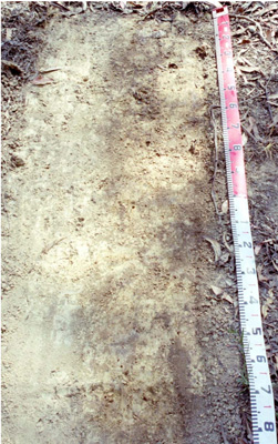 Acidic-mottled, Dystrophic, Yellow Dermosol | |
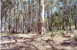
| Spargo Creek (Daylesford Ballan Road), Ballan district, central Victorian Highlands | |||
| Rolling low hills | |||
| Ordovician Castlemaine Group sediments: undifferentiated marine turbiditic sandstone, mudstone, black shale, minor granule conglomerate | |||
| Mid slope | |||
| 3% | |||
| East | |||
Horizon | Depth (cm) | Description | ||
O2 | 0–1 | |||
A1 | 1–15 | Greyish brown (10YR5/2); silty loam; apedal massive structure; earthy ped fabric; firm consistence (dry); clear boundary to: | ||
A3 | 15–25 | Brown (10YR5/3); silty loam; moderate fine prismatic structure; rough ped fabric; very firm consistence (dry); gradual boundary to: | ||
B1 | 25–40 | Light yellowish brown (2.5Y6/4) with common medium faint light brownish grey (10YR6/2) mottles; silty clay loam; many medium to coarse angular sandstone fragments and small to medium subangular quartz pebbles; moderate fine prismatic structure; rough ped fabric; firm consistence (dry); gradual boundary to: | ||
B2 | 40–60 | Light grey (2.5Y7/2) with common medium faint pale yellow (2.5Y7/4) mottles; silty clay; very few coarse angular siltstone coarse fragments; strong medium prismatic, parting to fine and very fine structure; very firm consistence (dry); gradual boundary to: | ||
B3 | 60–95 | White (2.5Y8/3) with common medium distinct pale yellow (2.5Y7/4) mottles; light clay(silty); few angular siltstone coarse fragments; weak medium prismatic, parting to fine prismatic structure; firm consistence (dry); gradual boundary to: | ||
C/R | 95–150 | White (5Y8/2); light clay (silty). | ||
| Management considerations | ||||
| This is a pale, acidic soil with a high silt component and a uniform to gradational increase in clay content with depth and little surface organic matter. Acidic soils are restricted in uptake of certain nutrients as well as being intolerance for some plant species (due in part to the increasing mobilisation of aluminium and manganese). The application of lime is the main method of increasing the pH, reducing toxic levels of nutrients to plants while increasing the availability of nutrients such as calcium, potassium and molybdenum. These soils are also like to be erosion prone where exposed (dispersive) and have a relatively low liquid limit (losing their strength). Some mottling occurs at depth above the weathered sediments (becoming kaolinised). This indicates restricted drainage, though less than where texture contrast soils have developed. | ||||
Analytical data
Site CLRA53 | Sample depth | pH | EC | NaCl | Ex Ca | Ex Mg | Ex K | Ex Na | Ex Al | Ex Acidity | FC –10kPa | PWP –1500kPa | KS | FS | Z | C | |
Horizon | cm | H2O | CaCl2 | dS/m | % | cmolc/kg | cmolc/kg | cmolc/kg | cmolc/kg | mg/kg | cmolc/kg | % | % | % | % | % | % |
A1 | 1–15 | 4.9 | 4.3 | 0.06 | N/R | N/R | N/R | N/R | N/R | N/R | N/R | N/R | N/R | 9.6 | 22.4 | 32 | 32 |
A3 | 15–25 | 5 | 4.3 | 0.05 | N/R | N/R | N/R | N/R | N/R | N/R | N/R | N/R | N/R | 7.6 | 18.1 | 32 | 39.5 |
B1 | 25–40 | 5.1 | 4.4 | <0.05 | N/R | 0.3 | 0.48 | 0.35 | 0.16 | N/R | 13 | N/R | N/R | 7.9 | 21.4 | 31 | 38 |
B2 | 40–60 | 5.2 | 4.3 | <0.05 | N/R | 0.12 | 0.59 | 0.16 | 0.13 | N/R | 9.1 | N/R | N/R | 6.1 | 15.1 | 38 | 38.5 |
B3 | 60–95 | 5 | 4.2 | <0.05 | N/R | N/R | N/R | N/R | N/R | N/R | N/R | N/R | N/R | 1.1 | 6 | 53.5 | 39.5 |
© State of Victoria (Agriculture Victoria) 1996 - .

This work, Victorian Resources Online, is licensed under a Creative Commons Attribution 4.0 licence. You are free to re-use the work under that licence, on the condition that you credit the State of Victoria (Agriculture Victoria) as author, indicate if changes were made and comply with the other licence terms.
The licence does not apply to ‘branding’ or some ‘images or photographs’ that may be owned by third parties. We ask you to seek prior approval to use images using the VRO feedback form. Access to higher quality images can also be provided on request.
This page was last updated on .