
Weathering of Ferruginised Regolith
 |
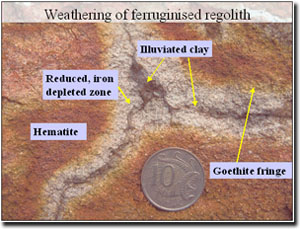
This image shows the upper part of a ferricrete in the Hanson Plain Sand which has some prominent redoximorphic features associated with fissures. |
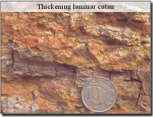 |
This image illustrates the effect of progressive clay accumulation within a laminar fissure. The shrink-swell nature of the clay is also clearly visible. |
 |
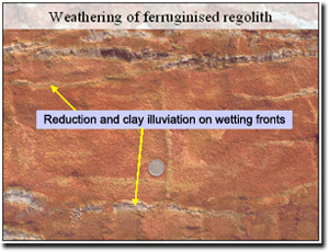
This close up image of the weathering regolith clearly illustrates the strong spatial relationship between fissure, clay accumulation and redox front. |
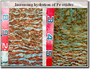 |
Traversing the profile from deepest to shallowest we can see the fate of the ferricrete under increasing influence of redox conditions. As wetter conditions are more prevalent at the surface, this traverse from deep to shallow represents a hydromorphic sequence. As there has been more time for weathering in the upper part of the profile it also represents a chronosequence. The image on the left shows profile features at 1.7-2.1 m depth. The image on the right shows profile features at 1.2-1.5 m depth. Tiger mottles are at their most developed in the deeper horizon but are starting to become less prominent in the overlying horizon. Red colours are duller indicating loss or hydration of hematite. The grey colours are also less distinct and have more mottling within them, indicating contemporary gleying processes subsequent to weathering of the regolith. |
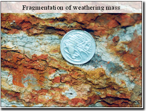 |
This close up image illustrates the fragmentation of the weathering mass. Just to the left of the 20 cent coin, the rounding of the residual gravel can be seen. These relics of the regolith are extremely hard and require a geopick to shatter them. In contrast, the pale grey material can be crumbled into primary particles with relative ease. |
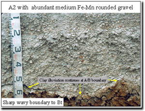 |
As the land surface deflates, the weathering front moves relatively deeper into the regolith. Clay illuviation continues through the profile with clay loss from the upper horizons and clay accumulation at depth. As clay is washed out of the upper part of the B horizon (at 0.6 m in this image) the remnants of the ferricrete, now rounded gravels, are left stranded in the A2 horizon. Over time these accumulate. Slope processes, in particular soil creep and flow within the A2 horizon, can lead to preferential loss and accumulation of these gravels in different slope positions. |
 |
The material in this picture has been taken from the A2c horizon. Transported gravels (soil creep in wet conditions) can settle into wetter parts of the landscape and become re-cemented as extremely hard pisolite. The weathering of these gravels has resulted in domination by colours. This can be attributed to manganese compounds, although the material would still be referred to as being ferro-manganiferous i.e. having both iron and manganese oxides. |
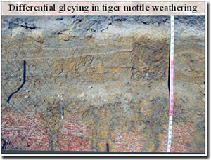 |
This deep profile shows strongly developed ‘tiger mottles’ at the base of the pit which are interrupted by vertical features showing gleying or waterlogging. As we are only seeing this in vertical section it is difficult to know how these features are connected. A transverse section through the profile is needed. They may be independent sinks or they may be connected as polygons surrounding residual columns of tiger mottled material. They may be the result of biological activity e.g. large tap roots creating zones of preferential water movement. Alternatively, they may be the result of shrinkage and swelling i.e. the Hanson Plain Sand is underlain by Gellibrand Marl which is a reactive clay. The latter explanation seems harder to accommodate than the biological one, but without further excavation in the horizontal plain we can only speculate. |
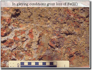 |
This image is a close up of a feature in the profile shown in the previous slide. It shows the base of one of the wet zones in the soil. The sharp contrast between the ‘tiger mottles’ at the left and lower parts of the image and the yellow-grey mottled material above indicates a preferentially wet volume of soil. Some of the gravels close to this zone show loss of hematite and a dominance of manganese oxides (darker material). |
 |
The yellow-grey mottled clay is a classic feature of a periodically wet soil. The gravels in this soil material have undergone extreme hydrolysis in reducing conditions. The mottling pattern is a product of this weathering. There now appears to be very little residual hematite i.e. lack of red colours. The gravel that does remain is easily broken and has dark, lustrous centres. These dark colours are interpreted in this instance as manganic and manganiferous oxides. |
© State of Victoria (Agriculture Victoria) 1996 - .

This work, Victorian Resources Online, is licensed under a Creative Commons Attribution 4.0 licence. You are free to re-use the work under that licence, on the condition that you credit the State of Victoria (Agriculture Victoria) as author, indicate if changes were made and comply with the other licence terms.
The licence does not apply to ‘branding’ or some ‘images or photographs’ that may be owned by third parties. We ask you to seek prior approval to use images using the VRO feedback form. Access to higher quality images can also be provided on request.
This page was last updated on .