
Rainfall
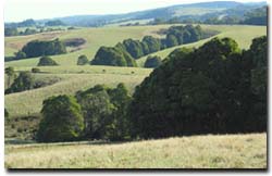 The Weeaproinah area receives an average annual rainfall of 1 937 mm. | Rainfall across the region is closely related to elevation and latitude. The calculated average annual rainfall varies from 469 mm in the lee of the Lovely Banks Monocline to 1892 mm along the ridge of the Otway Range. The majority of rain falls in winter and spring, with August as the wettest month across the region. The Bureau of Meteorology records Weeaproinah with the highest mean annual rainfall (1937 mm) and Lovely Banks Reservoir with the region’s lowest mean annual rainfall (526 mm). The occurrence of salinity and landslides show strong correlations to the rainfall surface. |
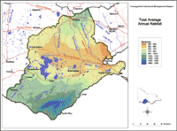 Total Average Annual Rainfall | This map has been developed by Peter Dahlhaus and Tony Davidson, using ANUCLIM, a climatic model developed by the Centre for Resource and Environmental Studies at the Australian National University. Original data was provided by the Bureau of Meteorology. The map provides an overview of the Total Average Annual Rainfall across the region. |
© State of Victoria (Agriculture Victoria) 1996 - .

This work, Victorian Resources Online, is licensed under a Creative Commons Attribution 4.0 licence. You are free to re-use the work under that licence, on the condition that you credit the State of Victoria (Agriculture Victoria) as author, indicate if changes were made and comply with the other licence terms.
The licence does not apply to ‘branding’ or some ‘images or photographs’ that may be owned by third parties. We ask you to seek prior approval to use images using the VRO feedback form. Access to higher quality images can also be provided on request.
This page was last updated on .