
Soils on Older Consolidated Sediments
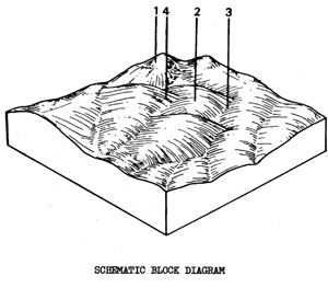
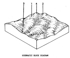
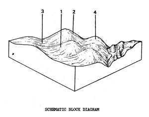
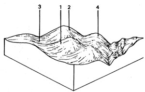
Orcd - Broad Ridge tops with Duplex Soils on Ordovician Sedimentary Rock | Org - Plains with Duplex Soils on Ordovician Sedimentary Rock | Orgd - Plains with Duplex Soils on Ordovician Sedimentary Rock. Drier than Org | Orm - Moderate Slopes with Duplex Soils on Ordovician Sedimentary Rock | Ors - Steep Hills with Gradational Soils on Ordovician Sedimentary Rock | Orsd - Steep Hills with Gradational Soils on Ordovician Sedimentary Rock. Drier than Ors
Org - Plains with Duplex Soils on Ordovician Sedimentary Rock
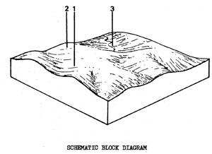 | Gentler Ordovician land which has been separated from the Ors unit on the basis of slope, vegetation and soils. The unit is scattered across the northern part of the Shire and occupies 6.7% of the survey area, 47 km2. There are some areas of salting on the lower slopes and drainage lines, particularly where this unit is close to Tgn. The salting appears to be associated with clearing; the increased water infiltrating through the soil and picking up soluble salts within the Tertiary and Ordovician sediments. These salts are then deposited where, the water comes to the surface. It is mainly used for grazing and cereal cropping but some parts are still forested. SOILS The soils do not vary much except in the drainage lines, although they do get shallow towards the crests. The description below is fairly typical of soil profiles found in Component 1. |
Mottled Yellow Duplex Soils
Factual Keys: Dy 3.41/CL-L, 10-40 cm/slate and sandstone, 80-180 cm
Horizon | Depth (cm) | Description |
A1 | 0-10 | Brownish black (10YR 3/2) when moist, clay loams, apedal and massive; consistence when dry is hard; pH 5.8; sharp boundary. |
A2 | 10-30 | Greyish yellow brown (10YR 4/2) when moist; clay loam; apedal, hydrophobic and massive; consistence when dry is very hard; pH 5.8; sharp .boundary. |
B | 30-150 | Yellowish brown (10YR 5/6) when moist; red mottling; medium clay; strong angular blocky 2 mm; consistence when dry is very hard, pH 5.5; with 4% gravel. |
C | 150 | Slates and sandstone interbedded. |
| COMPONENT Proportion % | 1 80 | 2 15 | 3 5 |
| CLIMATE | |||
| Rainfall(av.) mm | Annual 585 – 685 | ||
| Temperature(av.) °C | Annual 12 | ||
| GEOLOGY | |||
| Age, rock | Ordovician, slate and sandstone | ||
| TOPOGRAPHY | |||
| Landscape | Slightly dissected plains | ||
| Elevation (range) m | 210 - 350 | ||
| Local relief (av.) m | 8 | ||
| Drainage pattern | Dendritic | ||
| Drainage density km/km2 | 1.8 | ||
| Land form | Undulating plain | ||
| Position on land form | Long gentle slope | Crest | Drainage line |
| Slope (range) %, slope shape | 3-6 ; Straight | 1-3 ; Convex | 1-3 ; Concave |
| NATIVE VEGETATION | |||
| Structure | Open forest | ||
| Dominant species | E. viminalis, E. obliqua | E. obliqua, E. radiata | E. ovata, E. obliqua |
| SOIL | |||
| Parent material | In-situ weathered rock | In-situ weathered rock | Alluvium-clay. silt, sand and gravel |
| Description | Mottled yellow duplex soils | Mottled yellow duplex soils | Mottled yellow and red gradational soils |
| Factual key | Dy 3.41 | Dy 3.41 | Gn 3 |
| Surface texture | Clay loam | Loam - clay loam | Clay loam |
| Permeability | Moderate-low | High | Low-moderate |
| Depth (range) m | 0.8 - 1.8 | 0.5 - 1.0 | 1.5 - 2.5 |
| LAND USE | |||
Grazing with some forestry and cropping (cereal) | |||
| SOIL DETERIORATION | |||
| Critical land features | Hard setting surfaces | Hard setting surfaces, dispersibility | Moderate dispersibility, poorly drained site, hard setting surfaces, seasonal high watertable |
| Processes | Overland flow, leaching of salts | Overland flow, leaching of salts | Overland flow, accumulation of salts, periodic waterlogging |
| Forms | Minor sheet, rill and gully erosion, surface compaction | Minor sheet and rill erosion, surface compaction | Salting, minor gully erosion |
Orgd - Plains with Duplex Soils on Ordovician Sedimentary Rock. Drier than Org
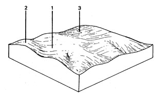 | Gently undulating plain on Ordovician sediments in the Bamganie area, near the Leigh River and in some isolated patches east of She Oaks. (it is similar to Org but has a drier climate.) The total area of the unit is 3.2 km2 which represents 0.4% of the Shire. The main soil is a mottled yellow, duplex soil formed on slates and sandstone; however, there are occasional sandy ridges. (Salting may occur on lower slopes and in the drainage lines, especially where the unit is close to Tgn or Tgnd. Gully erosion may occur in saltaffected areas. The main land use is grazing with some cereal cropping. SOILS The most common soil is that of Component 1. |
Mottled Yellow Duplex Soils
Factual Keys: Dy 3.41/FSL-LS, 10-40 cm/Ordovician sediments, 100-200 cm.
Horizon | Depth (cm) | Description |
A1 | 0-10 | Brownish black (10YR 3/2) when moist; fine sandy loam; apedal and massive; consistence when dry is hard; pH 5.8; sharp boundary. |
A2 | 10-30 | Greyish yellow brown (10YR 4/2) when moist; fine sandy loam; apedal and massive; consistence when dry is hard; pH 5.8; sharp boundary. |
B | 30-150 | Yellowish brown (10YR 5/6) when moist; red mottling; medium clay; strong angular blocky 2 mm; consistence when dry is very hard; pH 5.5; with 4% gravel. |
| COMPONENT Proportion % | 1 80 | 2 15 | 3 5 |
| CLIMATE | |||
| Rainfall(av.) mm | Annual 585-685 | ||
| Temperature(av.) °C | Annual 12 | ||
| GEOLOGY | |||
| Age, rock | Ordovician slate and sandstone | Remnants of Tertiary sandy capping over Ordovician sediments | Ordovician; slate and sandstone |
| TOPOGRAPHY | |||
| Landscape | Slightly dissected rolling plains in the "Sammie" area near the Leigh River | ||
| Elevation (range) m | 200 - 255 | ||
| Local relief (av.) m | 10 | ||
| Drainage pattern | Dendritic | ||
| Drainage density km/km2 | 1.3 | ||
| Land form | Rolling plain | ||
| Position on land form | Long gentle slope | Sandy ridges | Depression line |
| Slope (range) %, slope shape | 2-5 ; Straight | 1-3 ; Convex | 1-3 ; Concave |
| NATIVE VEGETATION | |||
| Structure | Open forest ? | ||
| Dominant species | E. Polyanthemos, Casuarina Spp. and others ? | E. Viminalis ?, Casuarina Spp. | E. Camaldulensis |
| SOIL | |||
| Parent material | In-situ weathered rook | Unconsolidated sands over in-situ weathered rock | Alluvium |
| Description | Mottled yellow duplex soils | Pale uniform sands over mottled yellow duplex soils | Mottled yellow duplex soils |
| Factual key | Dy 3.41 | Uc 1/Dy 3.41 | Dy 3.21 |
| Surface texture | Fine sandy loam | Sand - Loamy sand | Clay loam |
| Permeability | Moderate-low | High | Low-moderate |
| Depth (range) m | 1.0 - 2.0 | 1.0 - 2.0 | 1.5 - 2.5 |
| LAND USE | |||
Grazing with some cropping (cereal) | Grazing | Grazing with some cropping (cereal) | |
| SOIL DETERIORATION | |||
| Critical land features | Hard setting surfaces | Permeability, nutrient-holding capacity | Moderate dispersibility, poorly rained site, hard setting surfaces, seasonal high watertable |
| Processes | Overland flow, leaching of salts | Leaching | Overland flow, accumulation of salts, periodic waterlogging |
| Forms | Minor sheet, rill and gully erosion, surface compaction | Nutrient decline | Some salting, gully erosion |
Orcd - Broad Ridge tops with Duplex Soils on Ordovician Sedimentary Rock
 | Broad crests associated with the Orad land system to the north-east of the Shire. It represents the intermediate stage in natural erosion of the landscape that occurs between the broad crests capped with Tertiary sediments (Tgn and Tgnd) and the narrow crests of steep Ordovician country (Orsd). Although the Tertiary material has largely been removed by natural erosion, it still has some influence on the soil, e.g. the topsoil is sandier than usual. There is a group of about ten small areas of this unit east of Meredith, totalling 3.5 km2, or 0.5% of the Shire. The land is generally cleared and grazing is the main land use. SOILS The soils vary from red mottled yellow duplex soils through to red duplex soils where the influence of the Tertiary is stronger. The former are more common and an example is described below. |
Mottled Yellow Duplex Soils
Factual Key: Hy 3.41/FSL-LS, 10-40 cm/Ordovician sediments, 50-150 cm
Horizon | Depth (cm) | Description |
A1 | 0-10 | Brownish black (10YR 3/2) when moist; fine sandy loam; apedal and massive; consistence when dry is hard; pH 5.8; sharp boundary. |
A2 | 10-30 | Greyish yellow brown (10YR 4/2) when moist; fine sandy loam; apedal and massive; consistence when dry is very hard; pH 5.8; sharp boundary. |
B | 30-80 | Yellowish brown (10YR 5/6) when moist; with red mottling; medium clay; strong angular blocky 2 mm; consistence when dry is very hard; pH 5.5; with 4% gravel. |
C | 80+ | Weathering Ordovician sediments. |
| COMPONENT Proportion % | 1 100 |
| CLIMATE | |
| Rainfall(av.) mm | Annual 600 - 630 |
| Temperature(av.) °C | Annual 12 |
| GEOLOGY | |
| Age, rock | Ordovician slates and sandstones |
| TOPOGRAPHY | |
| Landscape | Some broader ridge tops west of Steiglitz |
| Elevation (range) m | 1688- 335 |
| Local relief (av.) m | 50 |
| Drainage pattern | Dendritic |
| Drainage density km/km2 | 1.1 |
| Land form | Broad ridge tops |
| Position on land form | Crest |
| Slope (range) %, slope shape | 1-5 ; Convex |
| NATIVE VEGETATION | |
| Structure | Low open forest to open forest |
| Dominant species | E. macrorhyncha, E. polyanthemos, E. goniocalyx |
| SOIL | |
| Parent material | In-situ weathered rock |
| Description | Mottled yellow acid duplex soils |
| Factual key | Dy 3.41 and Dr 3.41 |
| Surface texture | Fine sandy clay loam |
| Permeability | Moderate |
| Depth (range) m | 0.3 - 1.2 |
| LAND USE | |
Low quality forestry | |
| SOIL DETERIORATION | |
| Critical land features | Hard setting surface |
| Processes | Overland flow |
| Forms | Minor sheet erosion |
Orm - Moderate Slopes with Duplex Soils on Ordovician Sedimentary
 | Rolling terrain on Ordovician slates and sandstones to the north of the Shire. The total area of 6.7 km2 represents 1.0% of the Shire. The land has been separated from Org on the basis of slope and local relief. The steeper slopes of Orm increase the hazard of erosion on disturbed soil surfaces. Most of the land is cleared and it is generally used for grazing. SOILS The soils do not vary much except in the drainage lines and on some of the narrower create. The main variation is in depth to the sedimentary rock. The example below represents a fairly common profile. |
Mottled Yellow Duplex Soils
Factual Key: DY 3.41/CL-L, 10-40 cm/slates and sandstone, 60-120 cm
Horizon | Depth (cm) | Description |
A1 | 0-10 | Brownish black (10YR 3/2) when moist; clay loams; apedal and massive; consistence when dry is hard; pH 5.8; sharp boundary. |
A2 | 10-25 | Greyish yellow brown (10YR 4/2) when moist; clay loam; apedal, hydrophobic and massive; consistence when dry is very hard; pH 5.8; sharp boundary. |
B | 25-120 | Yellowish brown (10YR 5/6) when moist; red mottling; medium clay; strong angular blocky 2 mm; consistence when dry is very hard; pH 5.5; with 4% gravel. |
| COMPONENT Proportion % | 1 85 | 2 10 | 3 5 |
| CLIMATE | |||
| Rainfall(av.) mm | Annual 630 - 685 | ||
| Temperature(av.) °C | Annual 12 | ||
| GEOLOGY | |||
| Age, rock | Ordovician; slate and sandstone | ||
| TOPOGRAPHY | |||
| Landscape | Slightly dissected plains | ||
| Elevation (range) m | 310 - 350 | ||
| Local relief (av.) m | 13 | ||
| Drainage pattern | Dendritic | ||
| Drainage density km/km2 | 1.8 | ||
| Land form | Rolling plain | ||
| Position on land form | Long gentle slope | Crest | Drainage line |
| Slope (range) %, slope shape | 3-10 ; Straight | 1-3 ; Convex | 1-3 ; Concave |
| NATIVE VEGETATION | |||
| Structure | Open forest | Woodland | Open forest |
| Dominant species | E. viminalis, E. obliqua | E. obliqua, E. radiata | E. ovata, E. obliqua |
| SOIL | |||
| Parent material | In-situ weathered rock | In-situ weathered rock | Alluvium-clay, silt, sand and gravel |
| Description | Mottled yellow duplex soils | Shallow stony red gradational soils | Mottled yellow and red gradational soils |
| Factual key | Dy3.41 | Gn 3.71 | Gn 3 |
| Surface texture | Clay loam | Gravelly loam | Clay loam |
| Permeability | Moderate-low | High | Low-moderate |
| Depth (range) m | 0.6 - 1.2 | 0.4 - 0.7 | 1.5 - 2.5 |
| LAND USE | |||
Grazing with some forestry | |||
| SOIL DETERIORATION | |||
| Critical land features | Hard setting surfaces | Hard setting surfaces, dispersibility | Moderate dispersibility, poorly drained site, hard setting surfaces, seasonal high watertable |
| Processes | Overland flow, leaching of salts | Overland flow, leaching of salts | Overland flow, accumulation of salts, periodic waterlogging |
| Forms | Moderate sheet, rill and gully erosion | Minor sheet and rill erosion, surface compaction | Moderate salting, gully erosion |
Orh - Hills with Gradational Soils on Ordovician Sediments
 | Hilly terrain on Ordovician elates and sandstone located in the north-central and northwestern parts of the Shire. There are only a few areas of mappable dimensions and the total of 8.1 km2 represents 1.1% of the Shire. The slopes are not as steep as for Ore though the soils are fairly shallow and just as erodible. The sedimentary rock is often exposed or is just below the surface on the upper slopes and crests. Most of the land is cleared but is only capable of supporting grazing at a fairly low carrying capacity. The drainage lines often contain gullies, some of which are still actively eroding. It is similar to Orhd but the climate here is wetter. SOILS The most common soils are either mottled yellow gradational or duplex soils, often depending on the steepness of the slope. The soil described is common on Component 1. |
Red Mottled. Yellow Gradational Soils - Fine Structure
Factual Key: Gn 3.71/CL, 5-15 cm/slates and sandstone, 50-120 cm
Horizon | Depth (cm) | Description |
A | 0-8 | Brown (7.5YR 4/3) when moist; gravelly clay loam; apedal, massive and hydrophobic; consistence when dry is hard; pH 5.5; diffuse boundary. |
B1 | 8-30 | Bright reddish brown (5YR 5/6) when moist with abundant red brown mottles; light medium clay; moderate angular blocky 3 mm; consistence when moist is firm; pH 5.8; diffuse boundary with colluvial stones. |
B2 | 30-70 | Reddish brown (5YR 4/6) when moist with abundant red mottles; medium clay; strong angular blocky 3 mm; consistence when moist is firm; pH 6.0; diffuse boundary. |
B/C | 70-80 | As B2 with 60-80% weathering. Ordovician sedimentary rock. |
R | 80+ | Ordovician rock. |
| COMPONENT Proportion % | 1 48 | 2 45 | 3 5 | 4 2 |
| CLIMATE | ||||
| Rainfall(av.) mm | Annual 660 - 710 | |||
| Temperature(av.) °C | Annual 12 | |||
| GEOLOGY | ||||
| Age, rock | Ordovician; elates and sandstones | |||
| TOPOGRAPHY | ||||
| Landscape | Hilly areas in the north of the Shire | |||
| Elevation (range) m | 213 - 350 | |||
| Local relief (av.) m | 45 | |||
| Drainage pattern | Dendritic | |||
| Drainage density km/km2 | 3.4 | |||
| Land form | Hills | |||
| Position on land form | Dry exposed slopes | Crest | Drainage line | Moist protected elopes |
| Slope (range) %, slope shape | 10-25 ; Straight | 0-10 ; Convex | 1-10 ; Concave | 8-20 ; Straight |
| NATIVE VEGETATION | ||||
| Structure | Open forest | Tall open forest | ||
| Dominant species | E. dives, E. obliqua E. viminalis, E. radiata | E. obliqua, E. dives, E. viminalis, E. radiata | E. radiata, E. viminalis, E. obliqua | E.obliqua, E. ovata, E. radiata, E. viminalis |
| SOIL | ||||
| Parent material | In-situ weathered rock | In-situ weathered rock | Alluvium, clay, silt, sand, gravel | In-situ weathered rock |
| Description | Mottled yellow gradational or duplex soils, fine structure | Shallow stony red and yellow gradational soils | Black rational soil, (variable) | Mottled yellow gradational or duplex soils, fine structure |
| Factual key | Gn 3.71 or Dy 3.41 | Gn 3.71 | Gn 3 | Gn 3.71 or Dy 3.41 |
| Surface texture | Fine sandy loam | Gravelly loam | Clay loam | Fine sandy loam |
| Permeability | High | High | Moderate-low | High |
| Depth (range) m | 0.5 - 1.2 | 0.3 - 0.8 | 0.7 - 1 | 0.8 - 1.8 |
| LAND USE | ||||
Mainly forestry, grazing | ||||
| SOIL DETERIORATION | ||||
| Critical land features | Steep slopes, hard setting surfaces | Moderate slopes, hard setting surfaces | Moderate permeability, hard setting surfaces, dispersibility, seasonal high watertable hard setting surfaces | |
| Processes | Overland flow | Overland flow | Overland flow, subsurface flow, waterlogging | Overland flow |
| Forms | Moderate sheet and rill erosion, surface compaction | Moderate sheet and rill erosion, surface compaction | Moderate gully. erosion, surface compaction | Minor sheet and rill erosion |
Orhd - Hills with Gradational Soils on Ordovician Sedimentary Rock. Drier than Orh
 | Hilly terrain on Ordovician sediments located within the generally steeper Ordovician country between Maude and the Durdidwarrah Reservoirs. There are only a few areas of mappable dimensions and the total of 4.2 km2 represents 0.6% of the Shire. It is similar to Qrh, but the climate is drier. The slopes are not as steep as for Orsd, but the soils are fairly shallow and are just as erodible. The sedimentary rock is often exposed or is just below the surface on the upper elopes and crests. The drainage lines often contain gullies, some of which are still actively eroding. Most of the land is cleared but is only capable of supporting grazing at a fairly low carrying capacity. SOILS The soils are fairly consistent within the land system. Where slopes are gentler and therefore the soils are deeper, duplex soils are more common than gradational soils. The soil described below represents an example of a gradational soil found on steeper slopes. |
Mottled, Yellow Gradational Soils - Fine Structure
Factual Key: Gn 3.71/CL, 5-15 cm/weathered Ordovician sediments, 30-100 cm
Horizon | Depth (cm) | Description |
A | 0-8 | Brown (7.5YR 4/3) when moist; gravelly clay loam; apedal, massive and hydrophobic; consistence when dry is hard; pH 5.5; diffuse boundary. |
B1 | 8-30 | Bright reddish brown (5YR 5/6) when moist with abundant red brown mottles; light medium clay; moderate angular blocky 3 mm; consistence when moist is firm; pH 5.8; diffuse boundary with colluvial stones. |
B2 | 30-50 | Reddish brown (5YR 4/6) when moist with abundant red mottles; medium clay; strong angular blocky 3 mm; consistence when moist is firm; pH 6.0; diffuse boundary. |
B/C | 50-60 | As B2 with 60-80% weathering. Ordovician sedimentary rock. |
R | 60+ | Ordovician rock. |
| COMPONENT Proportion % | 1 49 | 2 44 | 3 5 | 4 2 |
| CLIMATE | ||||
| Rainfall(av.) mm | Annual 580 - 600 | |||
| Temperature(av.) °C | Annual 12 | |||
| GEOLOGY | ||||
| Age, rock | Ordovician slates and sandstones | |||
| TOPOGRAPHY | ||||
| Landscape | Hilly areas mainly in north-east of the Shire | |||
| Elevation (range) m | 137 - 335 | |||
| Local relief (av.) m | 30 | |||
| Drainage pattern | Dendritic | |||
| Drainage density km/km2 | 1.3 | |||
| Land form | Hill | |||
| Position on land form | Dry exposed slopes | Crests | Drainage lines | Moist protected slopes |
| Slope (range) %, slope shape | 10-20 ; Straight | 2-10 ; Convex | 2-6 ; Concave | 5-15 ;.Straight |
| NATIVE VEGETATION | ||||
| Structure | Low open forest | Open forest | ||
| Dominant species | E. polyanthemos, E. leucoxylon | E. melliodora, E. sideroxylon | E. polyanthemos, E. ovata | E. viminalis, E. leucoxylon |
| SOIL | ||||
| Parent material | In-situ weathered rock | In-situ weathered rock | Alluvium; clay, silt, sand and gravel | In-situ weathered rock |
| Description | Yellow mottled duplex or gradational soils, fine structure | Shallow stony gradational soils | Black gradational soils (variable) | Yellow mottled duplex or gradational soils, fine structure |
| Factual key | Dy 3.41 | Gn 3.71 | Gn 3.4 | Dy 3.41 |
| Surface texture | Fine sandy loam | Gravelly loam | Clay loam | Fine sandy loam |
| Permeability | High | High | Moderately low | High |
| Depth (range) m | 0.5 - 1.0 | 0.2 - 0.5 | >1.0 | 0.8 - 1.5 |
| LAND USE | ||||
Grazing, low production forestry, recreation | ||||
| SOIL DETERIORATION | ||||
| Critical land features | Moderate slopes, hard setting surfaces, low fertility soils | Moderate slopes, hard setting surfaces; low fertility shallow soils | Moderate permeability, hard setting surfaces, dispersibility. Seasonal high watertable | Steep slopes, hard setting surfaces, low fertility soils |
| Processes | Overland flow | Overland flow | Overland flow, subsurface flow, periodic waterlogging | Overland flow |
| Forms | Moderate sheet and rill erosion, surface compaction | Moderate sheet and rill erosion, surface compaction | Moderate gully erosion, salting, surface compaction | Minor sheet and rill erosion, surface compaction |
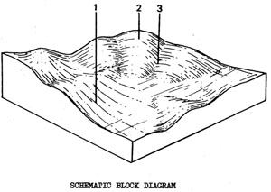
Ors - Steep Hills with Gradational Soils on Ordovician Sedimentary Rock
 | Steep hills and gorges on Ordovician elates and sandstones to the north of the Shire. Ors covers 37.6 km2 or 5.4% of the survey area. The combination of steep slopes, shallow erodible Boils and low fertility, limits the usefulness of this land for agronomic purposes. This low capacity for production has been recognised by past landowners and much of the land is uncleared. Those areas that are cleared are only capable of supporting grazing at a relatively low carrying capacity. There are often gullies in the drainage lines of grazing land. Recreation and low-quality forestry are other land uses that occur and, more recently, there has been some rural subdivision and bush-block development. The access tracks and clearings in some of these developed areas are often badly eroded, contributing sediments and dispersible clay to the Moorabool System. SOILS The soils of this unit are fairly consistent. They are shallow, stony, gradational soils except on small gently sloping areas where deeper duplex soils may occur. |
Mottled Yellow Gradational Soils- Fine Structure
Factual Key: Gn 3.71/CL, 5-15 cm/weathered Ordovician sediments, 30-100 cm
Horizon | Depth (cm) | Description |
A | 0-8 | Brown (7.5YR 4/3) when moist; fine sandy clay loam, sometimes with gravel; apedal, massive and hydrophobic; consistence when dry is hard; pH 5.5; diffuse boundary. |
B1 | 8-30 | Bright reddish brown (5YR 5/6) when moist with abundant red brown mottles; light medium clay; moderate angular blocky 3 mm; consistence when moist is firm; pH 5.8; diffuse boundary with colluvial stones. |
B2 | 30-50 | Reddish brown (5YR 4/6) when moist with abundant red mottles; medium clay; strong angular blocky 3 mm; consistence when moist is firm; pH 6.0; diffuse boundary. |
B/C | 50-60 | As B2 with 60-80% weathering. Ordovician sedimentary rock. |
R | 60+ | Ordovician rock. |
| COMPONENT Proportion % | 1 48 | 2 45 | 3 5 | 4 2 |
| CLIMATE | ||||
| Rainfall(av.) mm | Annual 610 - 700 | |||
| Temperature(av.) °C | Annual 12 | |||
| GEOLOGY | ||||
| Age, rock | Ordovician; slates and sandstones | |||
| TOPOGRAPHY | ||||
| Landscape | Closely dissected steep hilly areas to the north of the Shire | |||
| Elevation (range) m | 210 - 365 | |||
| Local relief (av.) m | 80 | |||
| Drainage pattern | Dendritic | |||
| Drainage density km/km2 | 6.5 | |||
| Land form | Hills and ridges | |||
| Position on land form | Dry exposed slopes | Crest | Drainage line | Moist protected slopes |
| Slope (range) %, slope shape | 15-35 ; Straight | 0-15, Convex | 2-10, Concave | 10-25 ; Straight |
| NATIVE VEGETATION | ||||
| Structure | Open forest | Tall open forest | ||
| Dominant species | E. dives, E. obliqua, E. viminalis, E. radiata | E. obliqua, E. dives, E. viminalis, E. radiata | E. radiata, E. viminalis E. obliqua | E. obliqua, E. ovata E. radiata, E. viminalis |
| SOIL | ||||
| Parent material | In-situ weathered rock | In-situ weathered rock | Alluvium, clay, silt, sand, gravel | In-situ weathered rock |
| Description | Mottled yellow gradational or duplex soils fine structure | Shallow stony red and yellow gradational soils | Dark gradational soils (variable) | Mottled yellow gradational or duplex soils fine structure |
| Factual key | Gn 3.71/Dy 3.41 | Gn 3.71 | Gn 4 | Gn 3.71/Dy 3.41 |
| Surface texture | Fine sandy loam | Gravelly loam | Clay loam | Fine sandy loam |
| Permeability | Moderate | High | Low | Moderate |
| Depth (range) m | 0.4 - 1.2 | 0.2 - 0.7 | 1 | 0.8 - 1.8 |
| LAND USE | ||||
The land is generally uncleared, some forestry, grazing areas that have been cleared | ||||
| SOIL DETERIORATION | ||||
| Critical land features | Steep slopes, hard setting surfaces | Moderate slopes, hard setting surfaces | Moderate permeability, hard setting surfaces, dispersibility, seasonal high watertable | Steep slopes, hard setting surfaces |
| Processes | Overland flow | Overland flow | Overland flow, subsurface flow, periodic waterlogging | Overland flow |
| Forms | Severe sheet and rill erosion | Severe sheet and rill erosion | Severe gully erosion | Severe sheet and rill erosion |
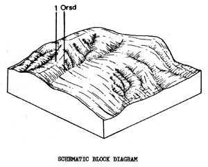
Orsd - Steep Hills with Gradational Soils on Ordovician Sedimentary Rock. Drier than Ors
 | Closely dissected terrain with steep rugged slopes and poor shallow soils in the northeast of the Shire. Having a total area of 46 km2, it comprises 6.6% of the total study area. The combination of steep elopes, shallow erodible soils and low fertility, limits the usefulness of this land for agronomic purposes. This low capacity for production has been recognised by past landowners and much of the land is uncleared. Those areas that are cleared are only capable of supporting grazing at a relatively low carrying capacity. There are often gullies in the drainage lines of grazing land. Recreation and low-quality forestry are other land uses that occur and, more recently, there has been some rural subdivision and bush-block development. The access tracks and clearings in some of these developed areas are often badly eroded, contributing sediments and dispersible clay to the Moorabool System. |
Mottled, Yellow Gradational Soils - Fine Structure
Factual Key: Gn 3.71/CL, 5-15 cm/weathered Ordovician sediments, 30-100 cm.
Horizon | Depth (cm) | Description |
A | 0-8 | Brown (7.5YR 4/3) when moist; fine sandy clay loam, sometimes with gravel; apedal, massive and hydrophobic; consistence when dry is hard; pH 5.5; diffuse boundary. |
B1 | 8-30 | Bright reddish brown (5YR 5/6) when moist with abundant red brown mottles; light medium clay; moderate angular blocky 3 mm; consistence when moist is firm; pH 5.8; diffuse boundary with colluvial stones. |
B2 | 30-50 | Reddish brown (5YR 4/6) when moist with abundant red mottles; medium clay; strong angular blocky 3 mm; consistence when moist is firm; pH 6.0; diffuse boundary. |
B/C | 50-60 | As B2 with 60-80% weathering. Ordovician sedimentary rock. |
R | 60+ | Ordovician rock. |
| COMPONENT Proportion % | 1 50 | 2 45 | 3 3 | 4 2 |
| CLIMATE | ||||
| Rainfall(av.) mm | Annual 560 - 600 | |||
| Temperature(av.) °C | Annual 12 | |||
| GEOLOGY | ||||
| Age, rock | Ordovician; slates and sandstones | |||
| TOPOGRAPHY | ||||
| Landscape | Closely dissected steep hilly areas mainly in the north-east of the Shire | |||
| Elevation (range) m | 91 - 350 | |||
| Local relief (av.) m | 52 | |||
| Drainage pattern | Dendritic | |||
| Drainage density km/km2 | 5.4 | |||
| Land form | Hills | |||
| Position on land form | Dry exposed slopes | Crest | Drainage lines | Moist protected slopes |
| Slope (range) %, slope shape | 14-40 ; Straight | 2-10 ; Convex | 2-6 ; Concave | 10-30 ; Straight |
| NATIVE VEGETATION | ||||
| Structure | Low open forest | Open forest | ||
| Dominant species | E. polyanthemos, E. macrorhyncha E. leucoxylon, E. sideroxylon E. viminalis, E. melliodora | E. polyanthemos, E. ovata, E. leucoxylon, E. melliodora | E. viminalis E. leucoxylon | |
| SOIL | ||||
| Parent material | In-situ weathered rock | In-situ weathered rock | Alluvium, clay, silt, sand, gravel | In-situ weathered rock |
| Description | Mottled yellow gradational or duplex soils, fine structure | Shallow stony gradational soils | Black gradational soils (variable) | Mottled yel1ow gradational or duplex soils, fine stricture |
| Factual key | Gn 3.71 | Gn 3.71 | Gn 3.4 | Gn 3.71 |
| Surface texture | Fine sandy loam | Gravelly loam | Clay loam | Fine sandy loam |
| Permeability | High | High | Moderately low | High |
| Depth (range) m | 0.5 - 1.0 | 0.1 - 0.4 | 1.0 | 0.5 - 1.2 |
| LAND USE | ||||
Low quality forestry; recreation, some grazing. Much of this land is Crown land. | ||||
| SOIL DETERIORATION | ||||
| Critical land features | Steep slopes, hard setting surfaces, low fertility, shallow soils | Moderate slopes, hard setting surfaces, low fertility shallow soils | Moderate permeability, hard setting surfaces, dispersibility, seasonal high watertable | Steep slopes, hard setting surfaces, low fertility soils |
| Processes | Overland flow | Overland flow | Overland flow, subsurface flow, periodic waterlogging | Overland flow |
| Forms | Severe sheet and rill erosion | Severe sheet and rill erosion | Severe gully erosion, Occasional salting | Severe sheet and rill erosion |
© State of Victoria (Agriculture Victoria) 1996 - .

This work, Victorian Resources Online, is licensed under a Creative Commons Attribution 4.0 licence. You are free to re-use the work under that licence, on the condition that you credit the State of Victoria (Agriculture Victoria) as author, indicate if changes were made and comply with the other licence terms.
The licence does not apply to ‘branding’ or some ‘images or photographs’ that may be owned by third parties. We ask you to seek prior approval to use images using the VRO feedback form. Access to higher quality images can also be provided on request.
This page was last updated on .