
Soils on Granitic Terrain
 | This unit represents 1.2% of the survey area or 2.5 km2. The main locations are around Kirk's and Gong Gong Reservoirs. Some parts are used for sand removal but it is mostly used for grazing. The area in the catchment to Gong Gong Reservoir is used for a pine plantation. This can be quite a hazardous unit unless it receives careful management. |
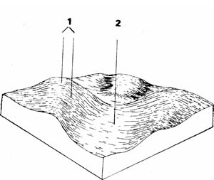
| COMPONENT | 1 | 2 |
| Proportion % | 30 | 70 |
| CLIMATE (Average) Rainfall mm | 500 - 560 | |
| *Temperature °C | Average annual 12°C | |
| *Seasonal growth limitations | Temperature less than 10°C May - September | |
| GEOLOGY Age, growth | Devonian; granite, granodiorite | Quaternary; wash-gravel sand and clay |
| TOPOGRAPHY Landscape | Hilly and rolling country in the centre south of the Shire | |
| Elevation (range) m | 520 | |
| Local relief (av.) m | 30 | |
| Drainage pattern | Dendritic | |
| Drainage density km/km2 | 4.8 | |
| Land form | Hill | Fan and terrace |
| Position on land form | Crest and slope | Drainage line |
| Slope (av.) ,%, slope shape | 2-10 ; Convex | 1-3 ; Straight |
| NATIVE VEGETATION Structure | Open forest | |
| Dominant species | E. viminalis E. radiata | E. ovata, E. obliqua, E. radiata |
| SOIL Parent material | In-situ weathered rock | Unconsolidated wash |
| Description | Mottled yellow red duplex soil | |
| Surface texture | Sandy loam | |
| Permeability | Moderate | Moderate-low |
| Depth (av.) in | 1 | 1 |
| LAND USE | Grazing | |
| Soil and gravel stripping | ||
| SOIL DETERIORATION Critical land features | Moderate elope, low permeability, hard setting surfaces | Poor drainage, low permeability, hard setting surfaces, dispersible soils |
| Processes | Overland flow, subsurface flow, deep seepage, leaching of salts | Accumulation of salts, overland flow and waterlogging, subsurface flow |
| Forms | Rill & gully erosion, sheet erosion | Salting, gully erosion, compaction |
| LAND UNIT: Devonian granodiorite | COMPONENT: 1 – Hills – Mottled yellow, red duplex soils | MAP SYMBOL: Dgn 1 |
CAPABILITY OF THE LAND TO SUPPORT VARIOUS ACTIVITIES | CAPABILITY OF THE LAND TO SUPPORT SUBDIVISION | ||||
ACTIVITY | RATING | MAJOR LIMITING FEATURES OF THE LAND | SUBDIVISION TYPE | RATING | MAJOR LIMITING ACTIVITIES |
| Building houses | Fair | Erosion during development; depth to hard rook. | Urban (sewered) | Fair | Shallow excavations; building houses: secondary roads (during development stage) |
| Absorption fields | Fair | Variable percolation rates; usually between moderately slow and moderately rapid. | Small Farmlets 4 ha | Fair | Small farm dams; gravel roads; access tracks. |
| Secondary roads | Fair | Erosion during construction; depth to hard rock. | Large Farmlets 16 ha | Fair | Small farm dams; access tracks. |
| Gravel roads | Fair | Erosion of table drains and batters. | Bush Blocks 4 ha. | Fair | Gravel roads; access tracks. |
| Access tracks | Fair | Erosion of track surface: table drains and batters. | |||
| Shallow excavations | Fair | Depth to hard rock. | |||
| Small farm dams | Fair | Depth to hard rook or sand layers. | |||
| Sewerage lagoons | Fair to poor | Slope; depth to hard rook. | |||
| Topsoil - Quality | Fair to good | Hard setting. | |||
| - Removal | Fair | Thin layer. | |||
| - Resowing | Poor | Infertile; easily eroded sub-soil layers. | |||
| Sand - Quality | Variable | Areas of granitic sand of varying quality. Thickness of deposit and depth. | |||
| - Operation | |||||
| Gravel - Quality | Poor | No gravel. | |||
| - Operation | |||||
| Grazing | Good to fair | Moderate sheet erosion with overgrazing | |||
| Cultivation | Fair to poor | Slope; low permeability of clay and hardsetting structureless topsoil results in a moderate risk of rill and sheet erosion. | |||
| Clearing | Fair | Erosion prior to pasture establishment; salting of lower land. | |||
EFFECT OF SUBDIVISION OF THE LAND ON TOWN WATER SUPPLY | ||
| URBAN: | Silt loss from development sites will be a problem unless earthworks are correctly managed. Land disturbance guidelines should be followed. | |
| FARMLET: | Erosion of tracks and gravel roads will be the main potential problem. | |
| BUSH BLOCKS: | As for farmlets | |
| LAND UNIT: Devonian granodiorite | COMPONENT: 2 – Fans & terraces – mottled yellow, red duplex soil | MAP SYMBOL: Dgn 2 |
CAPABILITY OF THE LAND TO SUPPORT VARIOUS ACTIVITIES | CAPABILITY OF THE LAND TO SUPPORT SUBDIVISION | ||||
ACTIVITY | RATING | MAJOR LIMITING FEATURES OF THE LAND | SUBDIVISION TYPE | RATING | MAJOR LIMITING ACTIVITIES |
| Building houses | Fair to poor | Soil drainage; temporary perched watertables. | Urban (sewered) | Fair to poor | Secondary roads; building houses; shallow excavations. |
| Absorption fields | Fair to poor | Impermeable B horizon; imperfect to poor drainage; temporary perched watertables. | Small Farmlets 4 ha | Fair to poor | Absorption fields - effluent; (otherwise-fair: gravel roads; access tracks; building houses). |
| Secondary roads | Fair to poor | Soil drainage; temporary perched watertables | Large Farmlets 16 ha | Fair to poor | Absorption fields - effluent; (otherwise-fair: access tracks; building houses). |
| Gravel roads | Fair | Soil drainage; erosion of table drains. | Bush Blocks 4 ha. | Fair. | Absorption fields - effluent; gravel roads; access tracks; building houses. |
| Access tracks | Poor | Soil drainage; A2 horizon-becomes "spewy" - boggy. | |||
| Shallow excavations | Fair | Soil drainage (seasonal). | |||
| Small farm dams | Good | ||||
| Sewerage lagoons | Fair | Slope - economical construction. | |||
| Topsoil - Quality | Good | Hard setting. | |||
| - Removal | Fair | Thin layer. | |||
| - Resowing | Poor | Infertile subsurface layers: some salting. | |||
| Sand - Quality | Good to poor | Variable quality. | |||
| - Operation | Fair | Thickness of overburdens. | |||
| Gravel - Quality | Very poor | No gravel. | |||
| - Operation | |||||
| Grazing | Fair to Good | Soil drainage; minor salting in some areas | |||
| Cultivation | Fair | Surface water flows; erosion; possible salting; hardsetting topsoil; impermeable clay; soil drainage. | |||
| Clearing | Fair to good | Erosion prior to pasture establishment. | |||
EFFECT OF SUBDIVISION OF THE LAND ON TOWN WATER SUPPLY | ||
| URBAN: | Soils are erodible and, though the slopes are gentler than in component 1 (the hills), silt from development will be a problem unless earthworks are correctly managed. The seasonally wet boggy nature of the bleached A2 horizon will necessitate construction works to be during the drier months. | |
| FARMLET: | Although most soils have fairly permeable A horizons, there are many poorly drained areas in which absorption fields will not function. Thee is frequently a temporary watertable perched on the clay for many weeks after heavy rain. The factors responsible are the impermeable B horizon (clay), the permeable A horizon and the gentle slopes. Site inspections for absorption trenches would be required. | |
| BUSH BLOCKS: | As for farmlets, except that soil drainage tends to be better under forest. | |
© State of Victoria (Agriculture Victoria) 1996 - .

This work, Victorian Resources Online, is licensed under a Creative Commons Attribution 4.0 licence. You are free to re-use the work under that licence, on the condition that you credit the State of Victoria (Agriculture Victoria) as author, indicate if changes were made and comply with the other licence terms.
The licence does not apply to ‘branding’ or some ‘images or photographs’ that may be owned by third parties. We ask you to seek prior approval to use images using the VRO feedback form. Access to higher quality images can also be provided on request.
This page was last updated on .