
Soils on Basaltic Terrain
Qbg - Quaternary Basalt - Grey Duplex Soils | Qbm - Quaternary Basalt - Mixture | Qbr - Quaternary Basalt - Red Gradational Soils | Qbs - Quaternary Basalt - Stony Rises | | | Qvc - Quaternary Volcanic Cone
Qbg - Quaternary Basalt - Grey Duplex Soils
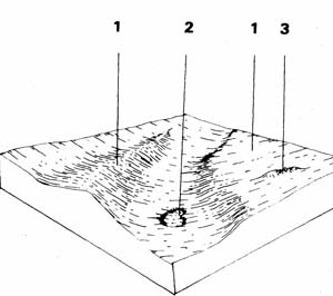 | The soils derived from the Recent basalt flows fall into either the grey or red types, each quite different in agricultural quality. This unit represents only 0.2% of the Bungaree Shire or 0.5 km2, but is a large component of the surrounding Shires. The grey duplex soils tend to become waterlogged and hard to work so they are used mainly for grazing with some cereal cropping, often as part of the pasture rotation. |
| COMPONENT | 1 | 2 | 3 |
| Proportion % | 95 | 3 | 2 |
| CLIMATE (Average) Rainfall mm | 500 - 730 | ||
| *Temperature °C | Average annual 12°C | ||
| *Seasonal growth limitations | Temperature less than 10°C May - September | ||
| GEOLOGY Age, growth | Pleistocene, basalt | ||
| TOPOGRAPHY Landscape | Extensive, slightly dissected plains | ||
| Elevation (range) m | 482 | ||
| Local relief (av.) m | 2 | ||
| Drainage pattern | Dendritic | ||
| Drainage density km/km2 | 2.2 | ||
| Land form | - | ||
| Position on land form | Lo , gentle upper slopes | Depression | Stony rise |
| Slope (av.) ,%, slope shape | 1-3 ; Straight | 1-2 ; Straight | 2-5 ; Convex |
| NATIVE VEGETATION Structure | Open forest | ||
| Dominant species | E. ovata, E. viminalis, E. rubida, E. obliqua | E. viminalis, E. rubida, E. obliqua, E. ovata | |
| SOIL Parent material | In-situ weathered rock | Alluvium | In-situ weathered rock |
| Description | Mottled yellow, grey sodic duplex soil, coarse structure | Black clay soil, uniform texture coarse structure | Red shallow stony gradational soil |
| Surface texture | Clay loam | Clay | Clay loan |
| Permeability | Moderate-low | Moderate | High |
| Depth (av.) in | 1.5 | 0.50 | |
| LAND USE | Grazing occasional cropping (cereal) | Grazing | |
| SOIL DETERIORATION Critical land features | Hard setting surfaces, slowly permeable subsoils | Clay soils beside creeks | Slopes |
| Processes | Overland flow, periodic waterlogging | Waterlogging, streambank undercutting | Overland flow, leaching |
| Forms | Compaction of surfaces, sheet erosion | Stream bank erosion | Sheet erosion, nutrient decline |
| LAND UNIT: Quaternary basalt plain | COMPONENT: 1 – yellow grey duplex soil | MAP SYMBOL: Qbg 1 |
CAPABILITY OF THE LAND TO SUPPORT VARIOUS ACTIVITIES | CAPABILITY OF THE LAND TO SUPPORT SUBDIVISION | ||||
ACTIVITY | RATING | MAJOR LIMITING FEATURES OF THE LAND | SUBDIVISION TYPE | RATING | MAJOR LIMITING ACTIVITIES |
| Building houses | Poor | Soil drainage; low areas pond water; high plasticity clay; high shrink-swell | Urban (sewered) | Poor | Building houses; secondary roads (fair to poor: shallow excavations depending on rock & drainage). |
| Absorption fields | Poor | Soil drainage; slow percolation rate. | Small Farmlets 4 ha | Poor | Absorption fields – effluent; building houses; gravel roads; access tracks; small farm dams. |
| Secondary roads | Poor | Soil drainage; high plasticity clay; high shrink-swell. | Large Farmlets 16 ha | Fair | Absorption fields – effluent; building houses; gravel roads; access tracks; (fair: small farm dams |
| Gravel roads | Fair | Soil drainage; high plasticity clay. | Bush Blocks 4 ha. | Poor | Uncleared areas are rare: absorption fields – effluent; building houses; gravel roads; access tracks. |
| Access tracks | Poor | Low bearing capacity when wet; soil drainage; boggy. | |||
| Shallow excavations | Fair to poor | High plasticity clay; shrink-swell; soil drainage; depth to hard rock; basalt floaters | |||
| Small farm dams | Fair to poor | Depth to rock; basalt floaters; (Flat areas – storage excavation ratio; catchment problems). | |||
| Sewerage lagoons | Good | Basalt floaters | |||
| Topsoil - Quality | Fair | Too clayey | |||
| - Removal | Poor | Thin layer | |||
| - Resowing | Fair | Soil drainage; heavy textured subsoil | |||
| Sand - Quality | Very poor | No sand | |||
| - Operation | |||||
| Gravel - Quality | Poor | Thin layer of iron stone gravel in high plastic clay. | |||
| - Operation | |||||
| Grazing | Good to fair | Soil drainage, waterlogging of low areas which become boggy. | |||
| Cultivation | Fair to poor | Soil drainage; heavy textured hardsetting topsoil. | |||
| Clearing | Good | ||||
EFFECT OF SUBDIVISION OF THE LAND ON TOWN WATER SUPPLY | ||
| URBAN: | Urban development leads to a high pollution load from non-point sources which may be unacceptable in a domestic water supply catchment. However, there are no special features of this land component which would cause abnormal difficulties. | |
| FARMLET: | Failure of absorption trenches will be a more severe risk to water supply if the land is subdivided more intensively. This is because: 1. Quantity of pollutant; there are more potential sources of pollution. 2. Sites: There will be less choice of disposal sites on small blocks. Some are likely to be restricted to particularly bad areas. However the risk of septic pollution will only be reduced, not removed by making the blocks larger. It would be preferable that effluent disposal did not rely on soil absorption (NOTE: percolation tests done in dry conditions often indicate rapid rates of absorption, while in winter the same sites show very slow rates – this may be related to cracking of the dry soil). If effluent disposal does not rely on soil absorption and is not likely to be a risk, then there are no special comments concerning water quality. Subdivision intensity can be increased. | |
| LAND UNIT: Quaternary basalt plain | COMPONENT: 2 – Depression-black clay soil, uniform texture | MAP SYMBOL: Qbg 2 |
CAPABILITY OF THE LAND TO SUPPORT VARIOUS ACTIVITIES | CAPABILITY OF THE LAND TO SUPPORT SUBDIVISION | ||||
ACTIVITY | RATING | MAJOR LIMITING FEATURES OF THE LAND | SUBDIVISION TYPE | RATING | MAJOR LIMITING ACTIVITIES |
| Building houses | Poor to very poor | Soil drainage; surface flows; shrink-swell (very poor: flood prone) | Urban (sewered) | Poor to very poor | Building houses; secondary roads; shallow excavations. |
| Absorption fields | Very poor | Poor soil drainage; surface flows; seasonally low percolation rates. | Small Farmlets 4 ha | Very poor | Absorption fields - effluent; building houses; gravel roads; access tracks |
| Secondary roads | Poor | Soil drainage; surface flows; shrink-swell; high plasticity clay. | Large Farmlets 16 ha | Very poor | Absorption fields - effluent; building houses; access tracks. |
| Gravel roads | Poor | Soil drainage; surface flows; shrink-swell; high plasticity clay. | Bush Blocks 4 ha. | Very poor. | Absorption fields - effluent; building houses; gravel roads; access tracks. (Note: uncleared areas are rare). |
| Access tracks | Very poor | Soil drainage; low strength; boggy material. | |||
| Shallow excavations | Poor | Poor drainage; high plasticity clay. | |||
| Small farm dams | Fair to poor | Embankment material; storage/excavation ratio. | |||
| Sewerage lagoons | Poor | Proximity to drainage line; embankment material. | |||
| Topsoil - Quality | Poor | Too clayey. | |||
| - Removal | Good | Poorly drained; high plastic sub-soil. | |||
| - Resowing | Fair | No sand. | |||
| Sand - Quality | Very poor | ||||
| - Operation | |||||
| Gravel - Quality | Poor | Gravel deposits rare. | |||
| - Operation | |||||
| Grazing | Fair | Soil drainage; severe pugging. | |||
| Cultivation | Poor | Soil drainage; surface flows; clayey topsoil. | |||
| Clearing | Fair | Surface flows. | |||
EFFECT OF SUBDIVISION OF THE LAND ON TOWN WATER SUPPLY | ||
| URBAN: | The poor drainage, risk of shallow surface flows of water and in some areas, deep flooding, limits the capability of this component for urban development. These factors also present a serious risk to water supply quality. | |
| FARMLET AND BUSH BLOCK: | There is a severe risk of pollution by effluent if disposal trenches are located on or near this component. If included in any farmlet subdivision, it should only be used for grazing. Housing and access tracks and roads should be kept well clear of this unit. | |
| LAND UNIT: Quaternary basalt plain | COMPONENT: | MAP SYMBOL: |
CAPABILITY OF THE LAND TO SUPPORT VARIOUS ACTIVITIES | CAPABILITY OF THE LAND TO SUPPORT SUBDIVISION | ||||
ACTIVITY | RATING | MAJOR LIMITING FEATURES OF THE LAND | SUBDIVISION TYPE | RATING | MAJOR LIMITING ACTIVITIES |
| Building houses | Poor | Depth to rock; boulders and surface stones | Urban (sewered) | Very poor | Shallow excavations (otherwise-poor: building houses; secondary roads |
| Absorption fields | Poor | Depth to rock; boulders and surface stones; variable soil drainage | Small Farmlets 4 ha | Poor | Small farm dams; absorption fields - effluent; building houses; gravel roads; access tracks. |
| Secondary roads | Poor | Depth to rook; boulders and surface stones. | Large Farmlets 16 ha | Poor | Small farm dams, absorption fields - effluent; building houses; access tracks |
| Gravel roads | Poor | Surface stones and boulders. | Bush Blocks 4 ha. | Poor | Absorption fields - effluent, building houses; gravel roads; access tracks. |
| Access tracks | Poor | Surface stones and boulders. | |||
| Shallow excavations | Very poor | Depth to hard rock; boulders and surface stones. | |||
| Small farm dams | Very poor | Depth to hard rock; boulders; catchment requirements; excessive percolation rate. | |||
| Sewerage lagoons | Very poor | Depth to hard rock; boulders, excessive percolation rate of material. | |||
| Topsoil - Quality | Good | Clayey: stony. | |||
| - Removal | Poor | Surface stones and boulders, thin layer. | |||
| - Resowing | Fair | Surface stones and boulders. | |||
| Sand - Quality | Very poor | No sand. | |||
| - Operation | |||||
| Gravel - Quality | Poor | Small quantities; stoniness; boulders. | |||
| - Operation | |||||
| Grazing | Low | Surface stones; shallow soils. | |||
| Cultivation | Severe | Surface stones and boulders; undulating micro-relief. | |||
| Clearing | Moderate | Surface stones and boulders; undulating micro-relief affect | |||
EFFECT OF SUBDIVISION OF THE LAND ON TOWN WATER SUPPLY | ||
| URBAN: | The physical constraints of shallow stony soils over hard rock limit the capability of this component for urban development. However, if these limitations are overcome, there are no special features of this component which would cause abnormal pollution problems, other than those normally associated with urban development. | |
| FARMLET AND BUSH BLOCK: | Again, the constraints of shallow stony soils over hard rock will limit the capability of this component for most of the activities associated with farmlets. With sufficient financial input, most of these limitations can be overcome with. No abnormal effects on water quality other than those usually anticipated with intensive construction works. Sites for effluent absorption would require examination on this component. | |
Qbs - Quaternary Basalt - Stony Rises
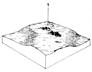 | This unit represents 0.7% of the survey area or 1.5 km2. As the unit is characterised by the surface basalt boulders it has limited uses and is generally used for grazing, although possibly it could be used for tree crops provided that they were frost tolerant. |
| COMPONENT | 1 100 |
| Proportion % | |
| CLIMATE (Average) Rainfall mm | 760 - 800 |
| *Temperature °C | Average annual 12.8°C |
| *Seasonal growth limitations | Temperature less than 10oC May - September |
| GEOLOGY Age, growth | Pleistocene, basalt |
| TOPOGRAPHY Landscape | Scattered low stony rises in the north of the Shire |
| Elevation (range) m | 500 |
| Local relief (av.) m | 1 |
| Drainage pattern | - |
| Drainage density km/km2 | - |
| Land form | Stony rise |
| Position on land form | - |
| Slope (av.) ,%, slope shape | 1-2 ; Concave scarps. straight tops |
| NATIVE VEGETATION Structure | Woodland |
| Dominant species | E. viminalis, E. obliqua, E. radiata, E. ovata |
| SOIL Parent material | In-situ weathered rock |
| Description | Red shallow stony gradational soil |
| Surface texture | Clay loam |
| Permeability | High |
| Depth (av.) in | 0.8 |
| LAND USE | Grazing |
| SOIL DETERIORATION Critical land features | Slope, shallow, permeable soils |
| Processes | Overland flow, leaching |
| Forms | Sheet erosion, nutrient decline |
| LAND UNIT: Quaternary basalt – stony rises | MAP SYMBOL: Qbs |
CAPABILITY OF THE LAND TO SUPPORT VARIOUS ACTIVITIES | CAPABILITY OF THE LAND TO SUPPORT SUBDIVISION | ||||
ACTIVITY | RATING | MAJOR LIMITING FEATURES OF THE LAND | SUBDIVISION TYPE | RATING | MAJOR LIMITING ACTIVITIES |
| Building houses | Poor | Depth to rock; boulders and surface stones. | Urban (sewered) | Very poor | Shallow excavations (otherwise-poor: building houses; secondary roads). |
| Absorption fields | Poor | Depth to rock; boulders and surface stones; variable soil drainage. | Small Farmlets 4 ha | Poor | Small farm dams; absorption fields - effluent; building houses; gravel roads; access tracks. |
| Secondary roads | Poor | Depth to rock; boulders and surface stones. | Large Farmlets 16 ha | Poor | Small farm dame; absorption, fields; building houses; access tracks. |
| Gravel roads | Poor | Surface stones and boulders. | Bush Blocks 4 ha. | Poor | Absorption fields; building houses; gravel roads; access tracks. |
| Access tracks | Poor | Surface stones and boulders. | |||
| Shallow excavations | Very poor | Depth to hard rock; boulders and surface stones. | |||
| Small farm dams | Very poor | Depth to hard rock; boulders; catchment requirements; excessive percolation rate. | |||
| Sewerage lagoons | Very poor | Depth to hard rock; boulders; excessive percolation rate of material. | |||
| Topsoil - Quality | Good | Clayey; stony. | |||
| - Removal | Poor | Surface stones and boulders; thin layer. | |||
| - Resowing | Fair | Surface stones and boulders. | |||
| Sand - Quality | Very poor | No sand. | |||
| - Operation | |||||
| Gravel - Quality | Poor | Small quantities; stoniness; boulders. | |||
| - Operation | |||||
| Grazing | Fair | Surface stones; shallow soils | |||
| Cultivation | Very poor | Surface stones and boulders; undulating micro-relief. | |||
| Clearing | Fair | Surface stones and boulders; undulating micro-relief - affecting machinery operation. | |||
EFFECT OF SUBDIVISION OF THE LAND ON TOWN WATER SUPPLY | ||
| URBAN: | The physical constraints of shallow stony soils over hard rock limit the capability of this component for urban development. However, if these limitations are overcome, there are no special features of this component which would cause abnormal pollution problems, other than those normally associated with urban development. | |
| FARMLET AND BUSH BLOCK: | Again, the constraints of shallow stony soils over hard rock will limit the capability of this component for most of the activities associated with farmlets. With sufficient financial input, most of these limitations can be overcome with no abnormal effects on water quality other than those usually anticipated with intensive construction works. Sites for effluent absorption would require examination on this component. | |
Qbr - Quaternary Basalt - Red Gradational Soils
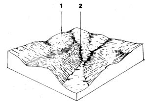 | This unit forms the best agricultural land in the survey area and is generally used for potato cropping although it is highly versatile and could be used for a wide range of agricultural products. The unit represents 16.7% of the Shire and covers an area of 34.5 km2. This land should be protected from further residential or industrial development and remain in its highly productive agricultural condition. |
| COMPONENT | 1 | 2 |
| Proportion % | 96 | 4 |
| CLIMATE (Average) Rainfall mm | 780 - 840 | |
| *Temperature °C | Average annual 12oC | |
| *Seasonal growth limitations | Temperature less than 10°C May - September | |
| GEOLOGY Age, growth | Pleistocene, basalt | |
| TOPOGRAPHY Landscape | Undulating plains north of the Shire | |
| Elevation (range) m | 660 | |
| Local relief (av.) m | 5 | |
| Drainage pattern | Dendritic | |
| Drainage density km/km2 | 1.6 | |
| Land form | Undulating plain | |
| Position on land form | Gentle slope | Depression |
| Slope (av.) ,%, slope shape | 1-6 ; Convex- | 1-2 ; Straight |
| NATIVE VEGETATION Structure | Open forest | |
| Dominant species | E. viminalis, E. radiata, E. obliqua | |
| SOIL Parent material | In-situ weathered rock and unconsolidated sediments | |
| Description | Red gradational soil, fine structure | Mottled yellow duplex soil, coarse structure |
| Surface texture | Clay loam | Clay loam |
| Permeability | High | Moderate-low |
| Depth (av.) in | 2 | 1.5 |
| LAND USE | Cropping (potatoes), grazing | Grazing, cropping (cereal) |
| SOIL DETERIORATION Critical land features | Slopes | Low permeability, hard setting surfaces |
| Processes | Overland flow, leaching | Waterlogging |
| Forms | Sheet erosion, wind erosion, nutrient decline | Compaction |
| LAND UNIT: Quaternary basalt – red gradational soil | COMPONENT: 1 – Gentle slopes – red gradational soil | MAP SYMBOL: Qbr 1 |
CAPABILITY OF THE LAND TO SUPPORT VARIOUS ACTIVITIES | CAPABILITY OF THE LAND TO SUPPORT SUBDIVISION | ||||
ACTIVITY | RATING | MAJOR LIMITING FEATURES OF THE LAND | SUBDIVISION TYPE | RATING | MAJOR LIMITING ACTIVITIES |
| Building houses | Good | Load bearing capacity when wet; shrink-swell. | Urban (sewered) | Good | |
| Absorption fields | Good | Small Farmlets 4 ha | Poor | Small farm dams; (otherwise good). | |
| Secondary roads | Good | Load bearing capacity when wet. | Large Farmlets 16 ha | Fair | Small farm dams; (otherwise good) (note – larger blocks are more likely to contain a satisfactory dam site). |
| Gravel roads | Good | Load bearing capacity when wet. | Bush Blocks 4 ha. | Very good | Few areas of bush. |
| Access tracks | Good to fair | Load bearing capacity when wet; (boggy in low areas). | |||
| Shallow excavations | Good | ||||
| Small farm dams | Poor | High percolation rate. | |||
| Sewerage lagoons | Poor | High percolation rate. | |||
| Topsoil - Quality | Good | Clayey, (but well structured). | |||
| - Removal | Good | ||||
| - Resowing | Good | ||||
| Sand - Quality | Very poor | No sand deposits. | |||
| - Operation | |||||
| Gravel - Quality | Very poor | No gravel deposits | |||
| - Operation | |||||
| Grazing | Very good | ||||
| Cultivation | Good | High phosphate fixation; slope; topsoil wash on long, cultivated slopes. | |||
| Clearing | Very good | ||||
EFFECT OF SUBDIVISION OF THE LAND ON TOWN WATER SUPPLY | ||
| URBAN: | Urban development leads to a high pollution load from non-point sources which may be unacceptable in a domestic water supply catchment. However, there are no special features of this land component which would cause abnormal difficulties. | |
| FARMLET & BUSH BLOCK: | This component has no special features which will cause abnormal problems concerning water quality. However, increasing the numbers of roads, tracks, houses and effluent disposal points will increase the levels of pollution. | |
| LAND UNIT: Quaternary basalt | COMPONENT: 2 – Depression: mottled yellow, red gradational soil | MAP SYMBOL: Qbr 2 |
CAPABILITY OF THE LAND TO SUPPORT VARIOUS ACTIVITIES | CAPABILITY OF THE LAND TO SUPPORT SUBDIVISION | ||||
ACTIVITY | RATING | MAJOR LIMITING FEATURES OF THE LAND | SUBDIVISION TYPE | RATING | MAJOR LIMITING ACTIVITIES |
| Building houses | Fair to poor | Soil drainage; surface ponding; shrink swell. | Urban (sewered) | Fair to poor | Building houses; secondary roads; shallow excavations. |
| Absorption fields | Poor | Soil drainage; water logging & surface flows in some areas; slow percolation rate | Small Farmlets 4 ha | Poor | Absorption fields - effluent; access tracks; gravel roads; building houses. |
| Secondary roads | Fair to poor | Soil drainage; high plasticity clay; shrink-swell | Large Farmlets 16 ha | Poor | Absorption fields - effluent; access tracks; building houses |
| Gravel roads | Fair to poor | Soil drainage; high plasticity clay. | Bush Blocks 4 ha. | Poor – little uncleared land. | Uncleared areas are rare: absorption fields - effluent; access tracks; gravel roads; building houses. |
| Access tracks | Poor | Low bearing capacity when wet; soil drainage; boggy. | |||
| Shallow excavations | Fair | High plasticity clay; shrink-swell; soil drainage. | |||
| Small farm dams | Good | High plasticity clay; shrink-swell. | |||
| Sewerage lagoons | Good | ||||
| Topsoil - Quality | Fair | Hard setting; heavy texture. | |||
| - Removal | Fair | Thin layer. | |||
| - Resowing | Fair | Poor drainage; high plasticity subsoil. | |||
| Sand - Quality | Very poor | No sand | |||
| - Operation | |||||
| Gravel - Quality | Very poor | No gravel. | |||
| - Operation | |||||
| Grazing | Good to fair | Soil drainage. | |||
| Cultivation | Fair to poor | Low permeability; poor drainage; heavy textured topsoil; erosion risk; proximity to drainage lines. | |||
| Clearing | Fair | Proximity to drainage lines. | |||
EFFECT OF SUBDIVISION OF THE LAND ON TOWN WATER SUPPLY | ||
| URBAN: | Urban development leads to a high pollution load from non-point sources which may be unacceptable in a domestic water supply catchment. However, there are no special features of this land component which would cause abnormal difficulties, other than its proximity to watercourses. | |
| FARMLET: | This component occurs on the lower slopes and drainage lines of the land system and is prone to poor drainage, water-logging and often surface flows. Severe risk of pollution by effluent if disposal relies on soil absorption. Disposal trenches will be far less prone to failure if located on component 1 of this land system (i.e. red gradational soils further up the slope). | |
| BUSH BLOCK: | As for farmlets (Note-uncleared areas are rare). | |
Qbm - Quaternary Basalt - Mixture
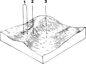 | This unit consists of a dark red gradational soil and a mixture of the good red gradational soils on the crest and upper slopes and a poorer grey sodic duplex soil on the lower slopes and in depressions. The area represents 26.1% of the survey area (53.9 km2. It is located mainly in the central part of the Shire, and is generally used for cropping. However only the better red gradational soils are used for row crops, the remainder being used for cereal crops or grazing. |
| COMPONENT | 1 | 2 | 3 |
| Proportion % | 34 | 33 | 33 |
| CLIMATE (Average) Rainfall mm | 800 - 840 | ||
| *Temperature °C | Average annual 12oC | ||
| *Seasonal growth limitations | Temperature less than 10oC May - September | ||
| GEOLOGY Age, growth | Pleistocene, basalt | ||
| TOPOGRAPHY Landscape | Slightly dissected plain north of the Shire | ||
| Elevation (range) m | 280 | ||
| Local relief (av.) m | 4 | ||
| Drainage pattern | Dendritic | ||
| Drainage density km/km2 | 2.3 | ||
| Land form | Undulating plain | ||
| Position on land form | Crest and upper slope | Mid slope | Lower slope and depression |
| Slope (av.) ,%, slope shape | 1-6 ; Convex | 2-7 ; Straight | 1-2 ; Concave |
| NATIVE VEGETATION Structure | Open forest | ||
| Dominant species | E. viminalis, E. obliqua, E. radiata | ||
| SOIL Parent material | In-situ weathered rock | Unconsolidated sediments | |
| Description | Red gradational soil , fine structure | Dark red gradational soil, fine structure | Mottled yellow sodic duplex soil, coarse structure |
| Surface texture | Clay loam | Loam | Clay loam |
| Permeability | High | High | Moderate-low |
| Depth (av.) in | 2 | 1.5 | 1.5 |
| LAND USE | Cropping, grazing (potatoes) | Cropping (cereal), grazing, cropping (potatoes) | Grazing, cropping |
| SOIL DETERIORATION Critical land features | Slope, exposure | Slope, hard setting surfaces | Low permeability, hard setting surfaces |
| Processes | Leaching, overland flow | Leaching, overland flow | Waterlogging |
| Forms | Sheet and wind erosion, nutrient decline | Compaction, wind & sheet erosion, nutrient decline | Compaction |
| LAND UNIT: Quaternary basalt - mixture | COMPONENT: 1 – Crests – Red gradational soils | MAP SYMBOL: Qbm 1 |
CAPABILITY OF THE LAND TO SUPPORT VARIOUS ACTIVITIES | CAPABILITY OF THE LAND TO SUPPORT SUBDIVISION | ||||
ACTIVITY | RATING | MAJOR LIMITING FEATURES OF THE LAND | SUBDIVISION TYPE | RATING | MAJOR LIMITING ACTIVITIES |
| Building houses | Good | Load bearing capacity when wet; shrink-swell | Urban (sewered) | Good | |
| Absorption fields | Good | Small Farmlets 4 ha | Poor | Small farm dams (otherwise good) | |
| Secondary roads | Good | Load bearing capacity when wet | Large Farmlets 16 ha | Fair | Small farm dams (otherwise good) (Note- larger blocks are more likely to contain a satisfactory dam site) |
| Gravel roads | Good | Load bearing capacity when wet | Bush Blocks 4 ha. | Very good | Few areas of bush |
| Access tracks | Good to fair | Load bearing capacity when wet (boggy in low areas) | |||
| Shallow excavations | Good | ||||
| Small farm dams | Poor | High percolation rate | |||
| Sewerage lagoons | Poor | High percolation rate | |||
| Topsoil - Quality | Good | Clayey (but well structured) | |||
| - Removal | Good | ||||
| - Resowing | Good | ||||
| Sand - Quality | Very poor | No sand deposits | |||
| - Operation | |||||
| Gravel - Quality | Very poor | No gravel deposits | |||
| - Operation | |||||
| Grazing | Very good | ||||
| Cultivation | Good | High phosphate fixation; slope; topsoil wash | |||
| Clearing | Very good | on long, cultivated slopes | |||
EFFECT OF SUBDIVISION OF THE LAND ON TOWN WATER SUPPLY | ||
| URBAN: | Urban development leads to a high pollution load from non--point sources which may be unacceptable in a domestic water supply catchment. However, there are no special features of this land component which would cause abnormal difficulties. | |
| FARMLET & BUSH BLOCK: | This component has no special features which will cause abnormal problems concerning water quality. However, increasing the numbers of roads, tracks, houses and effluent disposal points will increase the levels of pollution. | |
| LAND UNIT: Quaternary basalt - mixture | COMPONENT: 2 – Mid-slope – Dark red gradational soils | MAP SYMBOL: Qbm 2 |
CAPABILITY OF THE LAND TO SUPPORT VARIOUS ACTIVITIES | CAPABILITY OF THE LAND TO SUPPORT SUBDIVISION | ||||
ACTIVITY | RATING | MAJOR LIMITING FEATURES OF THE LAND | SUBDIVISION TYPE | RATING | MAJOR LIMITING ACTIVITIES |
| Building houses | Good | Low shrink-swell. | Urban (sewered) | Good | |
| Absorption fields | Good | Small Farmlets 4 ha | Pair | Dams (otherwise - very good). | |
| Secondary roads | Good | Low bearing capacity when wet. | Large Farmlets 16 ha | Fair | Dams |
| Gravel roads | Good | Low bearing capacity when wet. | Bush Blocks 4 ha. | Very good | Very little uncleared land. |
| Access tracks | Good | Low bearing capacity when wet. | |||
| Shallow excavations | Good | ||||
| Small farm dams | Fair | Moderate to rapid percolation rate. | |||
| Sewerage lagoons | Poor | Excessive percolation rate. | |||
| Topsoil - Quality | Good | Clayey (but friable). | |||
| - Removal | Good | ||||
| - Resowing | Good | ||||
| Sand - Quality | Very poor | No sand. | |||
| - Operation | |||||
| Gravel - Quality | Very poor | No gravel. | |||
| - Operation | |||||
| Grazing | Very low | ||||
| Cultivation | Low to moderate | High phosphate fixation; slope; topsoil wash on long, cultivated slopes; proximity to drainage lines; soil structure is poorer than for component 1 (crests). | |||
| Clearing | Very low | ||||
EFFECT OF SUBDIVISION OF THE LAND ON TOWN WATER SUPPLY | ||
| URBAN: | Urban development leads to a high pollution load from non-point sources which may be unacceptable in a domestic water supply catchment. However, there are no special features of this land component which would cause abnormal difficulties. | |
| FARMLETS &BUSH BLOCKS: | This component has no special features which will cause abnormal problems concerning water quality. However, increasing the numbers of roads, tracks, houses and effluent disposal points will increase the levels of pollution. | |
| LAND UNIT: Quaternary basalt - mixture | COMPONENT: 3 – Lower slope – yellow duplex soil | MAP SYMBOL: Qbm 3 |
CAPABILITY OF THE LAND TO SUPPORT VARIOUS ACTIVITIES | CAPABILITY OF THE LAND TO SUPPORT SUBDIVISION | ||||
ACTIVITY | RATING | MAJOR LIMITING FEATURES OF THE LAND | SUBDIVISION TYPE | RATING | MAJOR LIMITING ACTIVITIES |
| Building houses | Fair to poor | Soil drainage; surface ponding; (some areas flood). | Urban (sewered) | Fair to poor | Building houses; secondary roads; shallow excavations |
| Absorption fields | Poor | Soil drainage; water logging & surface flows in some areas; slow percolation rate. | Small Farmlets 4 ha | Poor | Absorption fields – effluent; building houses; gravel roads; access tracks. |
| Secondary roads | Fair to poor | Soil drainage; high plasticity clay; shrink-swell. | Large Farmlets 16 ha | Poor | Absorption fields – effluent; building houses; access tracks. |
| Gravel roads | Fair to poor | Soil drainage; high plasticity clay; (some areas flood or pond water). | Bush Blocks 4 ha. | Poor | Uncleared areas are rare; absorption fields – effluent; building houses; gravel roads & access tracks. |
| Access tracks | Poor | Low bearing capacity when wet; soil drainage; boggy. | |||
| Shallow excavations | Fair | High plasticity clay; shrink-swell; soil drainage. | |||
| Small farm dams | Good | High plasticity clay; shrink-swell. | |||
| Sewerage lagoons | Good | ||||
| Topsoil - Quality | Fair | Hard setting; heavy texture. | |||
| - Removal | Poor | Thin layer. | |||
| - Resowing | Fair | Poor drainage; high plasticity subsoil. | |||
| Sand - Quality | Very poor | No sand. | |||
| - Operation | |||||
| Gravel - Quality | Very poor | No gravel. | |||
| - Operation | |||||
| Grazing | Good to fair | Soil drainage; heavy textured soil; hard setting. | |||
| Cultivation | Fair to poor | Lower permeability; poor drainage; heavy textured topsoil; erosion risk; proximity to drainage lines. | |||
| Clearing | Fair | Surface wash before pasture establishment; proximity to creeks | |||
EFFECT OF SUBDIVISION OF THE LAND ON TOWN WATER SUPPLY | ||
| URBAN: | Urban development leads to a high pollution load from non-point sources which may be unacceptable in a domestic water supply catchment. However, there are no special features of this land component which would cause abnormal difficulties, other than its proximity to watercourses. | |
| FARMLET: | This component occurs on the lower slopes and drainage lines of the land system and is prone to poor drainage, waterlogging and often, surface slows. Severe risk of pollution by effluent if disposal relies on soil absorption. Disposal trenches will be far less prone to failure if located on components 1 and 2 of this land system (i.e. red gradational and dark red gradational soils further up the slopes). | |
| BUSH BLOCKS | As for farmlets (NOTE: uncleared areas are rare). | |
Qvc - Quaternary Volcanic Cone
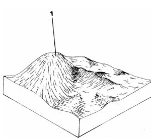 | This unit represents 1.6% of the survey area or 3.3 km2. The cones are the points of origin of most of the recent basalt flows and they vary slightly according to their lithology. Some cones are extremely steep whereas others barely rise above the basalt flow. The steeper ones are largely forested and in public ownership whereas the gentler ones are used for grazing. |
| COMPONENT | 1 |
| Proportion % | 100 |
| CLIMATE (Average) Rainfall mm | 500 - 965 |
| *Temperature °C | Average annual 12°C |
| *Seasonal growth limitations | Temperature less than 10°C May - September |
| GEOLOGY Age, growth | Pleistocene; basalt, scoria tuff |
| TOPOGRAPHY Landscape | Scattered volcanic cones |
| Elevation (range) m | 600 |
| Local relief (av.) m | 60 |
| Drainage pattern | Radial & Shut flow (Poorly developed channels) |
| Drainage density km/km2 | |
| Land form | Volcanic cone |
| Position on land form | Slope and crest |
| Slope (av.) ,%, slope shape | 5-40 ; Straight |
| NATIVE VEGETATION Structure | Open forest |
| Dominant species | E. viminalis, E. radiata |
| SOIL Parent material | In-situ weathered rock |
| Description | Stony red gradational soil |
| Surface texture | Clay loam |
| Permeability | High |
| Depth (av.) in | 1 |
| LAND USE | Grazing, forestry |
| SOIL DETERIORATION Critical land features | Steep slopes |
| Processes | Overland flow, leaching |
| Forms | Rill and sheet erosion, nutrient decline |
| LAND UNIT: Quaternary volcanic cones | MAP SYMBOL: Qvc |
CAPABILITY OF THE LAND TO SUPPORT VARIOUS ACTIVITIES | CAPABILITY OF THE LAND TO SUPPORT SUBDIVISION | ||||
ACTIVITY | RATING | MAJOR LIMITING FEATURES OF THE LAND | SUBDIVISION TYPE | RATING | MAJOR LIMITING ACTIVITIES |
| Building houses | 5-10% Fair 10-15% Poor | Slope-possible landslips; depth to rock. 15+% Very poor | Urban (sewered) | Fair to very poor | Building houses; secondary roads; shallow excavations (depends on slope & landslip risk). |
| Absorption fields | 8-15% Fair 15+% Poor | Slope-layout and construction | Small Farmlets 4 ha | Poor to very poor | Building houses; gravel roads; access tracks: small farm dams; absorption fields - effluent). |
| Secondary roads | 8-12% Fair 12-20% Poor | Slope-soil slumps; depth to rook. 20+% Very poor. | Large Farmlets 16 ha | Poor to very poor | Building houses; access tracks; small farm dams. |
| Gravel roads | 8-15% Fair 15-20% Poor | Slope-construction; rook; batters slump. 20+% Very poor. | Bush Blocks 4 ha. | Poor to very poor | House foundations; roads; (few uncleared areas). |
| Access tracks | 8-15% Fair 15-25% Poor | Slope-erosion & use. 25+% Very poor. | |||
| Shallow excavations | 5-10% Fair 10-20% Poor | Slope; depth to rock. 20+% Very poor. | |||
| Small farm dams | Very poor | Slope; rapid percolation rate; depth to rock. | |||
| Sewerage lagoons | Very poor | Slope; rapid percolation rate; depth to rock. | |||
| Topsoil - Quality | Good | Clayey (but well structured). | |||
| - Removal | Good to very poor | Slope-operations & access. | |||
| - Resowing | Fair to poor | Slope-machine operation & erosion risk. | |||
| Sand - Quality | Very poor | No sand. | |||
| - Operation | |||||
| Gravel - Quality | Variable | Scoria | |||
| - Operation | Variable | Slope-access & reclamation | |||
| Grazing | Good to poor | Depending on slope-sheet erosion; & stock management. | |||
| Cultivation | Fair to very poor | Depending on slope-sheet and rill erosion; &, machine operation. | |||
| Clearing | Good to poor | Depending on slops. | |||
EFFECT OF SUBDIVISION OF THE LAND ON TOWN WATER SUPPLY | ||
| URBAN, FARMLET and BUSH BLOCKS: | Although the water supply may not be greatly affected by development of the cones, the limitations caused by steep slopes and potential for landslips and soil slumping will require consideration. | |
© State of Victoria (Agriculture Victoria) 1996 - .

This work, Victorian Resources Online, is licensed under a Creative Commons Attribution 4.0 licence. You are free to re-use the work under that licence, on the condition that you credit the State of Victoria (Agriculture Victoria) as author, indicate if changes were made and comply with the other licence terms.
The licence does not apply to ‘branding’ or some ‘images or photographs’ that may be owned by third parties. We ask you to seek prior approval to use images using the VRO feedback form. Access to higher quality images can also be provided on request.
This page was last updated on .