
Thompson Creek Land System
Download the pdf version of this document: Thompson Creek Land System (PDF - 249 KB)
To view the information, PDF requires the use of a PDF reader. This can be installed for free from the Adobe website (external link).
| The lower reaches of the Thompson Creek catchment spread out into a wide alluvial plain. The plain appears almost flat, but it slopes towards the sea. The highest inland parts are some 20 m above the present valley floor of Thompson Creek, and some mild dissection into the plain occur along the sides of this valley. Road reserves and small shelter belts for stock contain the only remnants of the native vegetation. Low woodlands of Eucalyptus leucoxylon and Casuarina stricta appear to have been common, with Acacia pycnantha dominating the understorey. E. leucoxylon shows evidence of severe salt pruning several kilometres from the coast. Soils are duplex and sodic with dispersible subsoils. These plains are used for grazing and cropping. Minor problems are encountered from gully erosion along the margins of Thomson Creek, and soil salting occurs in the lowest areas close to the Connewarre land system. | 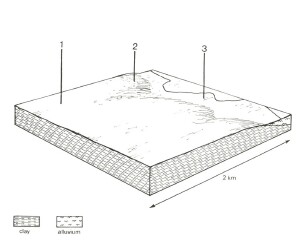 |
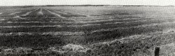 These flat plains are used mainly for grazing and cropping | 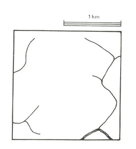 |
Area: 29 km2 | Component and its proportion of land system | ||
1 70% | 2 20% | 3 10% | |
| CLIMATE Rainfall, mm | Annual: 600, lowest January (30), highest August (60) | ||
| Temperature, 0oC | Annual: 14, lowest July (9), highest February (19) | ||
Temperature: less than 10oC (av.) July | |||
Precipitation: less than potential evapotranspiration October – mid April | |||
| GEOLOGY Age, lithology | Deeply weathered Plio-Pleistocene fluviatile sand and clay | ||
| TOPOGRAPHY Landscape | Flat to gently undulating plain near the south of Thompson Creek | ||
| Elevation, m | 0 – 50 | ||
| Local relief, m | 5 | ||
| Drainage pattern | Weak dendritic pattern with some deranged areas | ||
| Drainage density, km/km2 | 1.2 | ||
| Land form | Plain | Alluvial terrace | |
| Land form element | Middle and upper slope | Lower slope | - |
| Slope (and range), % | 0 (0-2) | 4 (2-10) | 1 (0-2) |
| Slope shape | Linear | Convex | Linear |
| NATIVE VEGETATION Structure | Low woodland | Open forest | Woodland |
| Dominant species | E. leucoxylon, Casuarina stricta, E. ovata | E. leucoxylon | E. leucoxylon, E. viminalis |
| SOIL Parent material | Sandy clay | Sandy clay | Sand, silt and clay |
| Description | Yellow-brown sodic duplex soils, coarse structure | Yellow sodic duplex soils | Brown sandy loam soils, uniform texture |
| Surface texture | Sandy loam | Sandy loam | Sandy loam |
| Permeability | Low | Moderate | High |
| Depth, m | >2 | >2 | >2 |
| LAND USE | Cleared areas: Dairy farming and beef cattle grazing on mainly improved pastures; some cereal cropping | ||
| SOIL DETERIORATION HAZARD Critical land features, processes, forms | Dispersible soils are prone to gully erosion. Sodic subsoils, low permeability and high water tables lead to soil salting. | Sodic subsoils and high water tables lead to soil salting. | Shallow saline water tables lead to soil salting, waterlogging and soil compaction. High discharge rates along watercourses lead to streambank erosion. |
© State of Victoria (Agriculture Victoria) 1996 - .

This work, Victorian Resources Online, is licensed under a Creative Commons Attribution 4.0 licence. You are free to re-use the work under that licence, on the condition that you credit the State of Victoria (Agriculture Victoria) as author, indicate if changes were made and comply with the other licence terms.
The licence does not apply to ‘branding’ or some ‘images or photographs’ that may be owned by third parties. We ask you to seek prior approval to use images using the VRO feedback form. Access to higher quality images can also be provided on request.
This page was last updated on .