
Simpson Land System
Download the pdf version of this document: Simpson Land System (PDF - 382 KB)
To view the information, PDF requires the use of a PDF reader. This can be installed for free from the Adobe website (external link).
| Small remnants of flat lateritic plateaux near Simpson and extending towards Irrewillipe are evidence of former widespread lateritization. Most lateritic hill capping have been removed by dissection, and this set of north-nor’-west- and south-sou’-east-orientated ridges is the only significant remnant to the west of the Range. The most common soils have gradational profiles containing lateritic ironstone. However, some profiles possess sand veneers in the surface horizons, with hardpans overlying mottled clays. Drainage of the landscape is poor, particularly where hardpans occur, and seasonal waterlogging is a problem. The ridges have been extensively cleared as part of the Heytesbury Settlement Scheme and dairy farming is the main land use. There are problems arising from low soil fertility and exposure to wind. Only one small area of native vegetation remains in the study area. | 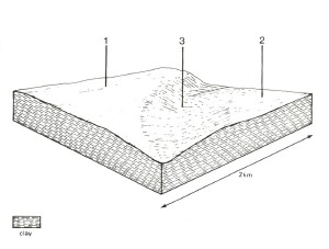 |
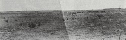 Clearing of these flat lateritic plateau has been very thorough, and little evidence remains of the former hardwood forests that covered them. | 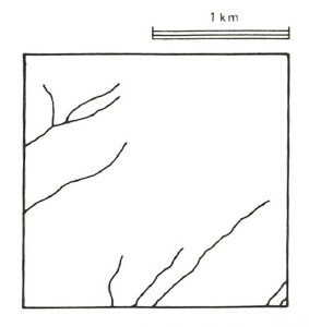 |
Area: 33 km2 | Component and its proportion of land system | ||
1 65% | 2 25% | 3 10% | |
| CLIMATE Rainfall, mm | Annual: 800 – 950, lowest January (35), highest August (110) | ||
| Temperature, 0oC | Annual: 13, lowest July (8), highest February (18) | ||
Temperature: less than 10oC (av.) June – August | |||
Precipitation: less than potential evapotranspiration late October – early April | |||
| GEOLOGY Age, lithology | Pliocene lateritized sand and clay Veneer of Quaternary sand | ||
| TOPOGRAPHY Landscape | Very gently undulating plateau with north-west and south-east dissection | ||
| Elevation, m | 150 – 170 | ||
| Local relief, m | 10 | ||
| Drainage pattern | Parallel | ||
| Drainage density, km/km2 | 1.0 | ||
| Land form | Plateau | ||
| Land form element | Middle and upper slopes, crest | Middle slope | Lower slope, depression |
Slope (and range), % | 4 (0-14) | 0 (0-3) | 5 (0-9) |
Slope shape | Straight (some convex) | Straight | Concave |
NATIVE VEGETATION Structure | Open forest | Closed scrub | Open forest |
Dominant species | E. obliqua, E. baxteri | Leptospermum juniperinum Melaleuca squarrosa, E. nitida, Casuarina littoralis | E. baxteri, E. ovata |
SOIL Parent material | Weathering lateritic remnants | Lateritic remnants covered by varying depths of sand | Alluvial sand and clay |
Description | Mottled yellow and red gradational soils with ironstone | Grey sand soils, structured clay underlay | Yellow-brown gradational soils, coarse structure |
Surface texture | Sandy loam | Sandy loam | Sandy loam |
Permeability | Moderate | Low | Low |
Depth, m | 1.7 | >2 | >2 |
| LAND USE | Cleared areas: Dairy farming; some beef cattle grazing Minor cleared areas: Hardwood forestry production | ||
| SOIL DETERIORATION HAZARD Critical land features, processes, forms | Low inherent fertility and phosphorus fixation lead to nutrient decline. Leaching of salts lead to increased salinity to drainage waters. | Low inherent fertility and leaching of permeable surface horizons lead to nutrient decline. Low permeabilities lead to seasonal waterlogging and soil compaction. | Low permeabilities and high seasonal watertables lead to seasonal waterlogging and soil compaction. Leaching of salts from landscape leads to increased salinity of drainage waters. |
© State of Victoria (Agriculture Victoria) 1996 - .

This work, Victorian Resources Online, is licensed under a Creative Commons Attribution 4.0 licence. You are free to re-use the work under that licence, on the condition that you credit the State of Victoria (Agriculture Victoria) as author, indicate if changes were made and comply with the other licence terms.
The licence does not apply to ‘branding’ or some ‘images or photographs’ that may be owned by third parties. We ask you to seek prior approval to use images using the VRO feedback form. Access to higher quality images can also be provided on request.
This page was last updated on .