
Mogg's Creek Land System
Download the pdf version of this document: Mogg's Creek Land System (PDF - 500 KB)
To view the information, PDF requires the use of a PDF reader. This can be installed for free from the Adobe website (external link).
| The terrain inland from Eastern View and Aireys Inlet consists of spurs and ridges with steep slopes and deep valleys. The outcropping Tertiary sediments are partly unconsolidated, but many beds are composed of quartzitic sandstones and siltstone. The lower parts of the landscape often possess outcrops of Cretaceous sediments. Open forests of Eucalyptus obliqua, E. sideroxylon and E. radiata occur over most of the landscape on duplex soils. The drier north- and west-facing slopes and steep slopes carry woodlands on shallow stony soils. The Cretaceous outcrops can be recognized by the increase in understorey cover and the occurrence of species such as Acacia mucronata and Cassinia longifolia. Some selective logging of these hills is undertaken, but the main use is for recreation such as bushwalking and picnicking. The steep slopes are popular with trail-bike-riders, and this often results in severe damage to the vegetation and soils. | 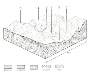 |
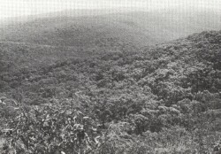 The valley of Painkalac Creek remains virtually uncleared, and is popular with bushwalkers and picnickers from nearby coastal resorts. | 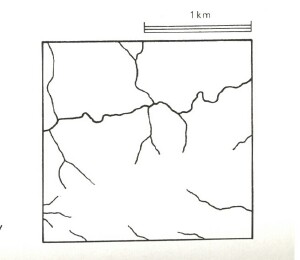 |
Area: 74 km2 | Component and its proportion of land system | |||||
1 30% | 2 20% | 3 7% | 4 25% | 5 8% | 6 10% | |
| CLIMATE Rainfall, mm | Annual: 800 – 1,050, lowest January (40), highest August (110) | |||||
| Temperature, 0oC | Annual: 13, lowest July (8), highest February (17) | |||||
Temperature: less than 10oC (av.) mid June – mid August | ||||||
Precipitation: less than potential evapotranspiration mid November – mid March | ||||||
| GEOLOGY Age, lithology | Paleocene unconsolidated clay, silt and sand; some silica cemented quartz sandstone and siltstone | Lower Cretaceous sandstone and mudstone | ||||
| TOPOGRAPHY Landscape | Deeply dissected hills | |||||
| Elevation, m | 0- 240 | |||||
| Local relief, m | 100 | |||||
| Drainage pattern | Dendritic | |||||
| Drainage density, km/km2 | 2.1 | |||||
| Land form | Hill | Valley floor | Hill | |||
| Land form element | Crest, north and west slopes | Lower slope, fan | Alluvial terrace | South and east slopes | Steep north slope | Steep lower slope |
| Slope (and range), % | 18 (6-45) | 7 (1-14) | 1 (0-2) | 18 (10-40) | 55 (40-65) | 45 (30-60) |
| Slope shape | Convex | Concave | Linear | Convex | Linear | Linear |
| NATIVE VEGETATION Structure | Woodland | Open forest | Open forest | Open forest | Low woodland | Open forest |
| Dominant species | E. radiata, E. obliqua, E. baxteri, E. sideroxylon | E. sideroxylon, E. cypellocarpa, E. obliqua, E. baxteri | E. obliqua, E. ovata, E. sideroxylon | E. obliqua, E. cypellocarpa | E. nitida, E. obliqua, Casuarina littoralis | E. obliqua, E. radiata, E. sideroxylon |
| SOIL Parent material | Clay, silt and sand | Alluvial clay, silt and sand | Alluvial clay, silt and sand | Clay, silt and sand | Mainly quartzitic sandstone and siltstone | Feldspathic sandstone and mudstone |
| Description | Red-yellow duplex soils | Yellow gradational soils, weak structure | Yellow-brown sodic duplex soils, coarse structure | Red-yellow duplex soils | Stony yellow gradational soils | Brown duplex soils |
| Surface texture | Fine sandy loam | Sandy loam | Fine sandy loam | Fine sandy loam | Gravelly sandy loam | Loam |
| Permeability | Moderate | High | Low | Moderate | Very high | Moderate |
| Depth, m | >2 | >2 | >2 | >2 | 0.7 | 0.9 |
| LAND USE | Uncleared areas: Nature conservation; hardwood forestry; active and passive recreation. Cleared areas: Residential; active recreation | |||||
| SOIL DETERIORATION HAZARD Critical land features, processes, forms | Weakly structured surface soils on steep slopes are prone to sheet erosion and compaction. Clay subsoils on steep slopes are prone to landslips. | Weakly structured soils receiving surface run-off from adjacent areas are prone to scour gullying, siltation and flooding. | Weak surface structure is prone to compaction leading to reduced permeability and increased overland flow. | Weakly structured surface soils on steep slopes are prone to sheet erosion and compaction. Clay subsoils on steep slopes are prone to landslips. | Stony shallow soils with weak structure and low water-holding capacity on dry steep slopes are prone to sheet erosion and landslides. | Steep slopes and weakly structured surfaces lead to sheet erosion. Clay subsoils on steep slopes subject to periodic saturation are prone to landslips. |
© State of Victoria (Agriculture Victoria) 1996 - .

This work, Victorian Resources Online, is licensed under a Creative Commons Attribution 4.0 licence. You are free to re-use the work under that licence, on the condition that you credit the State of Victoria (Agriculture Victoria) as author, indicate if changes were made and comply with the other licence terms.
The licence does not apply to ‘branding’ or some ‘images or photographs’ that may be owned by third parties. We ask you to seek prior approval to use images using the VRO feedback form. Access to higher quality images can also be provided on request.
This page was last updated on .