
Junction Track Land System
Download the pdf version of this document: Junction Track Land System (PDF - 554 KB)
To view the information, PDF requires the use of a PDF reader. This can be installed for free from the Adobe website (external link).
| The junction between Cretaceous and Tertiary sediments on the western periphery of the Otway Range is clearly reflected in vegetation changes. However, the junction is discontinuous and there is a belt of land where the higher parts of the landscape are capped by Tertiary sands with only occasional areas of silts and clays derived from Cretaceous sediments. The lower slopes are often steeper, with outcrops of Cretaceous sandstones and mudstones. Thus, the higher areas carry low woodlands of Eucalyptus nitida and E. baxteri, while the lower slopes support open forests or even tall open forests of E. obliqua and E. cypellocarpa. This landscape pattern is somewhat similar to the Redwater Creek land system. The major distinguishing feature is that the position in the landscape at which the Cretaceous sediments outcrop is very variable. The deposit of sand above the Cretaceous sediments varies in thickness, but is usually deep enough for the native vegetation to be dependent upon the sand for its nutrient supply. Most parts of this land system remain uncleared and unused. Some sand and gravel extraction pits have been established in the past. Pines have been established on small areas adjoining privately held land. | 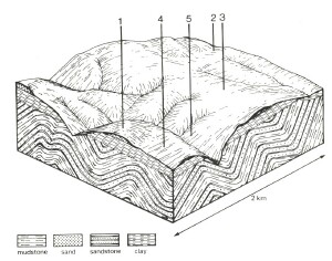 |
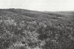 Most slopes support low woodlands of E. nitida, but outcrops of Cretaceous sediments can be recognised by the increases soil fertility and the accompanying change to open forests or tall open forests of E. obliqua and E. cypellocarpa. | 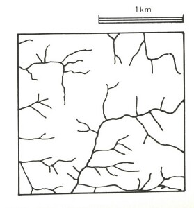 |
Area: 41 km2 | Component and its proportion of land system | ||||
1 30% | 2 5% | 3 20% | 4 30% | 5 15% | |
| CLIMATE Rainfall, mm | Annual: 1,100 – 1,400, lowest January (55), highest August (150) | ||||
Temperature, 0oC | Annual: 12, Lowest July (7), highest February (17) | ||||
Temperature: less than 10oC (av.) May – September | |||||
Precipitation: less than potential evapotranspiration late November – mid March | |||||
GEOLOGY Age, lithology | Paleocene unconsolidated sand, gravel, silt and clay | Lower Cretaceous sandstone and mudstone | |||
TOPOGRAPHY Landscape | Dissected hills with broad gentle hill cappings on western periphery of the Otway Range | ||||
Elevation, m | 30 - 270 | ||||
Local relief, m | 75 | ||||
Drainage pattern | Dendritic with some radial areas | ||||
Drainage density, km/km2 | 3.5 | ||||
| Land form | Hill | ||||
| Land form element | Crest, slope | Drainage line | Lower slope | Crest, slope | Steep slope |
Slope (and range), % | 15 (2-35) | 3 (0-5) | 9 (3-12) | 12 (2-25) | 30 (20-55) |
Slope shape | Convex | Concave | Linear | Convex | Linear |
NATIVE VEGETATION Structure | Low woodland | Closed scrub | Low open woodland | Open forest | Tall open forest |
Dominant species | E. nitida, E. baxteri | Leptospermum juniperinum, Melaleuca squarrosa | E. baxteri, E. nitida | E. baxteri, E. obliqua, E. radiata, E. nitida | E. obliqua, E. cypellocarpa |
SOIL Parent material | Quartz sand and gravel | Alluvial sand, plant remains | Quartz sand and gravel | Clay, silt, sand and gravel | In-situ weathered rock |
Description | Grey sand soils, uniform texture | Black sand soils, uniform texture | Grey sand soils with hardpans, uniform texture | Yellow gradational soils, weak structure | Brown gradational soils |
Surface texture | Loamy sand | Silty loam | Loamy sand | Sandy loam | Fine sandy clay loam |
Permeability | Very high | High | Very low | High | Moderate |
Depth, m | >2 | >2 | 1.1 | >2 | 1.5 |
| LAND USE | Uncleared areas: Sand and gravel extraction; hardwood forestry for posts, poles, fuel and some sawlogs on more fertile soils; nature conservation; water supply protection | ||||
| SOIL DETERIORATION HAZARD Critical land features, processes, forms | Very low inherent fertility and high permeability lead to nutrient decline. Steeper slopes with compacted soils are prone to sheet, rill and scour gully erosion. | High water tables lead to waterlogging. | Hardpans restrict vertical drainage leading to seasonal waterlogging. Very low inherent fertility, with some leaching of permeable high acidic surfaces, leads to nutrient decline. | Low inherent fertility and high permeability lead to nutrient decline. Weakly structured soils on steeper slopes are prone to sheet erosion. | Clay subsoils on steeper slopes subject to periodic saturation are prone to landslips. Soils of moderate permeability on steep slopes are prone to sheet erosion. |
© State of Victoria (Agriculture Victoria) 1996 - .

This work, Victorian Resources Online, is licensed under a Creative Commons Attribution 4.0 licence. You are free to re-use the work under that licence, on the condition that you credit the State of Victoria (Agriculture Victoria) as author, indicate if changes were made and comply with the other licence terms.
The licence does not apply to ‘branding’ or some ‘images or photographs’ that may be owned by third parties. We ask you to seek prior approval to use images using the VRO feedback form. Access to higher quality images can also be provided on request.
This page was last updated on .