
Chapple Vale Land System
Download the pdf version of this document: Chapple Vale Land System (PDF - 639 KB)
To view the information, PDF requires the use of a PDF reader. This can be installed for free from the Adobe website (external link).
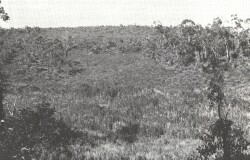
| Low woodlands of Eucalyptus nitida with understoreys of Leptospermum juniperinum, L. myrsinoides and Xanthorrhoea australis characterise these hills on the western periphery of the Otway Range. The soils are mainly deep, infertile and excessively drained sands, which contrast sharply with the adjacent gradational profiles of the Lower Cretaceous outcrops. Thus, although rainfall is high, moisture stress and soil infertility severely restrict plant growth. Some attempts have been made to clear tracts of this land and establish pastures for cattle grazing. Trial plots of pine species have also been established. Given sufficient fertilizer and soil ameliorants such as lime, pastures or even intensive crops could be successfully grown. However, the rates of such chemicals needed to achieve satisfactory production are high and most of the land remains in its natural state. The main activity has been the opening up of numerous soil and gravel extraction pits, most of which have failed to regenerate naturally and now remain as scars on the landscape. | 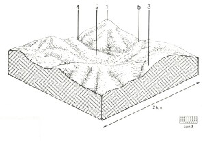 |
 The components of this land system are well demarcated by the structure and species composition of the native vegetation. | 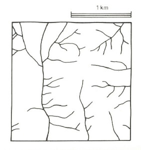 |
Area: 115 km2 | Component and its proportion of land system | ||||
1 15% | 2 15% | 3 55% | 4 10% | 5 5% | |
| CLIMATE Rainfall, mm | Annual: 1,000 – 1,350, lowest January (45), highest August (130) | ||||
Temperature, 0oC | Annual: 12, lowest July (7), highest February (18) | ||||
Temperature: less than 10oC (av.) June - September | |||||
Precipitation: less than potential evapotranspiration mid November – late March | |||||
GEOLOGY Age, lithology | Paleocene unconsolidated sand and gravel | ||||
TOPOGRAPHY Landscape | Dissected hills in the western part of the Otway Range | ||||
Elevation, m | 30 - 270 | ||||
Local relief, m | 60 | ||||
Drainage pattern | Dendritic with some radial areas | ||||
Drainage density, km/km2 | 4.0 | ||||
| Land form | Hill | Valley floor | |||
| Land form element | Crest, slope | Broad, slightly depressed areas of impeded drainage | Crest, slope | Steep lower slope | - |
Slope (and range), % | 25 (10-35) | 15 (5-20) | 20 (5-45) | 40 (25-50) | 8 (2-12) |
Slope shape | Convex | Linear | Convex | Linear | Concave |
NATIVE VEGETATION Structure | Tall shrubland | Closed heath | Low woodland | Woodland | Closed scrub |
Dominant species | E. nitida, Acacia suaveolens, E. baxteri, Leptospermum juniperinum | Casuarina littoralis, Xanthorrhoea australis, Leptospermum juniperinum, Leptospermum myrsinoides, Melaleuca squarrosa, Aotus ericoides, Dillwynia glaberrina, Epacris impressa, Epacris lanuginosa | E. nitida, E. radiata, E. baxteri, E. viminalis close to valley floor | E. baxteri, E. radiata, E. nitida | Melaleuca squarrosa, Leptospermum juniperinum, Casuarina littoralis, Gleichenia circinnata, Bauera rubioides, Sprengelia incarnata |
SOIL Parent material | Quartz sand and gravel | Quartz sand | Quartz sand | Quartz sand | Alluvial sand, plant remains |
Description | White sand soils, uniform texture | Grey sand soils with hardpans, uniform texture | Grey sand soils, uniform texture | Yellow sand soils, uniform texture | Black sand soils, uniform texture |
Surface texture | Coarse sand | Sandy loam | Loamy sand | Loamy sand | Silty loam |
Permeability | Very high | Very low | Very high | Very high | Low |
Depth, m | >2 | 0.6 | >2 | >2 | >2 |
| LAND USE | Uncleared areas: Gravel and sand extraction; nature conservation; water supply; active and passive recreation. | ||||
| SOIL DETERIORATION HAZARD Critical land features, processes, forms | Very low inherent fertility and high permeability leads to leaching of nutrients. Steeper slopes with compacted soils are prone to sheet, rill and scour gully erosion. | Hardpans restrict drainage leading to seasonal waterlogging. Very low inherent fertility with leaching of permeable acidic surface horizons leads to nutrient decline. | Very low inherent fertility and high permeability lead to nutrient decline. Steeper slopes with compacted soils are prone to sheet, rill and scour gully erosion. | Steeper slopes with weakly structured soils of low water-holding capacity are prone to sheet erosion. Low inherent fertility and high permeability lead to nutrient decline. | High water tables lead to waterlogging and soil compaction. Rapid run-off from adjacent hills leads to flooding and siltation. |
© State of Victoria (Agriculture Victoria) 1996 - .

This work, Victorian Resources Online, is licensed under a Creative Commons Attribution 4.0 licence. You are free to re-use the work under that licence, on the condition that you credit the State of Victoria (Agriculture Victoria) as author, indicate if changes were made and comply with the other licence terms.
The licence does not apply to ‘branding’ or some ‘images or photographs’ that may be owned by third parties. We ask you to seek prior approval to use images using the VRO feedback form. Access to higher quality images can also be provided on request.
This page was last updated on .