
Carlisle Land System
Download the pdf version of this document: Carlisle Land System (PDF - 620 KB)
To view the information, PDF requires the use of a PDF reader. This can be installed for free from the Adobe website (external link).
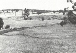
| High-level river terrace systems have developed along the Gellibrand River valley at Carlisle River, Gellibrand and Chapple Vale. Up to four different levels can be found, and mild dissection on the upper levels in quite complicated landscapes. The alluvial material varies from coarse sands and gravels to silts and clays and a variety of soils is found at different levels. Redistribution of sand over some areas has resulted in polygenetic soils with hardpan development. This further complicates the soil and vegetation pattern. Most of these terrace systems have been cleared, dairying being the major land use. Seasonal waterlogging is common and soil compaction may result from cattle grazing these areas in wet conditions. | 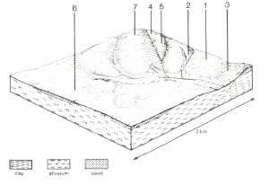 |
 Several levels can be found in this land system, with the highest levels being somewhat dissected. | 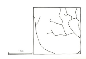 |
Area: 19 km2 | Component and its proportion of land system | ||||||
1 10% | 2 10% | 3 10% | 4 10% | 5 15% | 6 25% | 7 20% | |
| CLIMATE Rainfall, mm | Annual: 1,000 – 1,150, lowest January (45), highest August (130) | ||||||
| Temperature, 0oC | Annual: 13, lowest July (8), highest February (18) | ||||||
Temperature: less than 10oC (av.) June – September | |||||||
Precipitation: less than potential evapotranspiration mid November – late March | |||||||
| GEOLOGY Age, lithology | Recent alluvial clay, silt and sand shallowly overlying unconsolidated Palaeocene sand with some clay and silt. | ||||||
| TOPOGRAPHY Landscape | Elevated and, in parts, uplifted and dissected system of ancient cut and depositional terraces of the Gellibrand River. | ||||||
| Elevation, m | 30 – 180 | ||||||
| Local relief, m | 20 | ||||||
| Drainage pattern | Dendritic pattern in dissected areas; internal drainage elsewhere | ||||||
| Drainage density, km/km2 | 1.2 | ||||||
| Land form | Alluvial terrace | Scarp | Valley floor | Scarp | Mildly dissected alluvial terrace | ||
Land form element | Low level | - | - | - | Middle level | High level | |
Slope (and range), % | 30 (0-8) | 25 915-40) | 0 (0-1) | 15 (3-35) | 5 (0-9) | 3 (0-5) | 7 (1-10) |
Slope shape | Linear | Linear | Linear | Convex | Linear | Linear | Convex |
NATIVE VEGETATION Structure | Open forest | Open forest | Tall open forest | Woodland | Low open woodland | Open forest | Open forest |
Dominant species | E. obliqua, E. ovata | E. obliqua, E. viminalis | E. viminalis, E. obliqua, Acacia melanoxylon, E. ovata | E. radiata, E. nitida, E. baxteri, E. viminalis | E. nitida, E. radiata, E. baxteri | E. aromaphloia, E. radiata, E. ovata | E. obliqua, E. radiata, E. baxteri |
| SOIL Parent material | Alluvial clay, silt , some sand | Sand, silt and clay | Alluvial clay, silt and sand | Sand | Sand | Alluvial clay, silt with sand underlay | Alluvial clay, silt |
| Description | Yellow-brown gradational soils, coarse structure | Yellow gradational soils, weak structure | Grey gradational soils | Grey sand soils, uniform texture | Grey sand soils with hardpans, uniform texture | Grey sand soils, structured clay underlay | Mottled yellow and red gradational soils |
| Surface texture | Fine sandy loam | Sandy loam | Sandy clay loam | Loamy sand | Silty loam | Sandy loam | Sandy loam |
| Permeability | Low | High | Low | Very high | Very low | Low | Moderate |
| Depth, m | >2 | >2 | >2 | >2 | 0.6 | >2 | >2 |
| LAND USE | Cleared areas: Dairy farming; beef cattle grazing; open-range pig fattening; residential; water supply. Uncleared areas: Sand and gravel extraction; water supply; minor forest produce | ||||||
| SOIL DETERIORATION HAZARD Critical land features, processes, forms | Low permeability and high rainfall lead to seasonally high water tables with resulting waterlogging and soil compaction. | Low inherent fertility and high permeability lead to leaching of nutrients. Weakly structured surface soils on the steepest slopes are prone to sheet erosion. Saturation of clay subsoils on steep slopes leads to landslips. | Flooding and seasonal water table development lead to waterlogging, soil compaction and siltation. | Very low inherent fertility and high permeability lead to nutrient decline. Steeper slopes with compacted soils of low water-holding capacity are prone to sheet erosion. | Very low inherent fertility with leaching of permeable acidic surfaces leads to nutrient decline. Hardpans restrict drainage, leading to seasonal waterlogging. | Low inherent fertility with leaching permeable surface horizons leads to nutrient decline. Low profile permeability and perched seasonal water tables lead to waterlogging. | Low inherent fertility and phosphorus fixation lead to nutrient decline. |
© State of Victoria (Agriculture Victoria) 1996 - .

This work, Victorian Resources Online, is licensed under a Creative Commons Attribution 4.0 licence. You are free to re-use the work under that licence, on the condition that you credit the State of Victoria (Agriculture Victoria) as author, indicate if changes were made and comply with the other licence terms.
The licence does not apply to ‘branding’ or some ‘images or photographs’ that may be owned by third parties. We ask you to seek prior approval to use images using the VRO feedback form. Access to higher quality images can also be provided on request.
This page was last updated on .