
Cape Otway Land System
Download the pdf version of this document: Cape Otway Land System (PDF - 636 KB)
To view the information, PDF requires the use of a PDF reader. This can be installed for free from the Adobe website (external link).
| In the vicinity of Cape Otway and extending discontinuously to the west is an elevated plain of coastal dunes. The coastal margins of the plain are generally fronted by 100 m cliffs of calcarenite with possibly small primary dunes at the base of the cliffs. Behind the cliffs, the plain has an irregular dune topography that may extend several kilometres inland. The demarcation to other land systems is very sharp and easily defined. Woodlands of Eucalyptus viminalis with open grassy understoreys used to cover most areas, although shrubs resistant to salt- and salt-laden winds formerly colonized the coastal localities. Most areas have been cleared for grazing, but the establishment of improved pastures present difficulties. Overgrazing has resulted in severe wind erosion in some areas, and reclamation is difficult and expensive. | 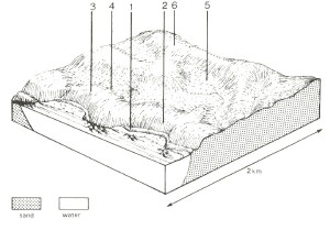 |
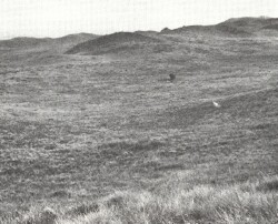 Large parts of the Cape Otway land system have been cleared and provide rough grazing for cattle on native grasses. |  |
Area: 36 km2 | Component and its proportion of land system | |||||
1 6% | 2 4% | 3 20% | 4 20% | 5 10% | 6 40% | |
| CLIMATE Rainfall, mm | Annual: 900 – 1,100, lowest January (45), highest July (105) | |||||
| Temperature, 0oC | Annual: 14, lowest July (10), highest February (18) | |||||
Temperature: less than 10oC (av.) July | ||||||
Precipitation: less than potential evapotranspiration late November - February | ||||||
| GEOLOGY Age, lithology | Recent sand and shell grit on a calcarenite basement | |||||
| TOPOGRAPHY Landscape | Elevated longitudinal coastal dunes at and to the west of Cape Otway | |||||
| Elevation, m | 0 – 155 | |||||
| Local relief, m | 15 | |||||
| Drainage pattern | Mainly absent; some dendritic areas | |||||
| Drainage density, km/km2 | 0.7 | |||||
| Land form | Foredune | Cliff | Longitudinal dune | Interdune corridor | Inland dune | |
| Land form element | - | - | Windward slopes | Leeward slopes | - | - |
| Slope (and range), % | 20 (15-40) | 65 (50-100) | 25 (5-50) | 20 (5-50) | 3 (0-9) | 25 (3-60) |
| Slope shape | Convex | Linear | Convex | Convex | Concave | Concave |
| NATIVE VEGETATION Structure | Tussock grassland | Open scrub | Open scrub | Woodland | Open forest | Woodland |
| Dominant species | Spinifex hirsutus, Scirpus nodosus, Calocephalus brownii | Casuarina stricta, Casuarina longifolia, Alyxia buxifolia | Alyxia buxifolia, Leucopogon parviflorus, Cassinia longifolia, Acacia verticillata, Leptospermum juniperinum, Helichrysum paralium | Casuarina stricta, E. viminalis, Leucopogon parviflorus | E. obliqua E. viminalis | E. viminalis |
| SOIL Parent material | Coarse sand, shell grit | Calcarenite, aeolian sand | Sand with calcarenite basement | Sand with calcarenite basement | Sand with calcarenite basement | Sand with calcarenite basement |
| Description | Yellow calcareous sand soils, uniform texture | Yellow calcareous sand soils, uniform texture | Brown calcareous sand soils, uniform texture | Brown calcareous sand soils, uniform texture | Red-yellow calcareous sand soils, uniform texture | Red-yellow calcareous sand soils, uniform texture |
| Surface texture | Coarse sand | Coarse sand | Loamy sand | Loamy sand | Loamy sand | Loamy sand |
| Permeability | Very high | Very high | Very high | Very high | Very high | Very high |
| Depth, m | >2 | 0.3 | >2 | >2 | >2 | 1.9 |
| LAND USE | Cleared areas: Beef cattle grazing on unimproved pastures; mining of calcarenite; residential; active recreation. Uncleared areas: Forest grazing of beef cattle; active and passive recreation; nature conservation; landscape conservation. | |||||
| SOIL DETERIORATION HAZARD Critical land features, processes, forms | Dune inherently unstable due to cyclical marine erosion. Low fertility, low water-holding capacity and vegetation sensitive to disturbance lead to wind erosion and leaching of nutrients. | Weakly structured sand soils of low water-holding capacity on steep slopes with vegetation sensitive to disturbance and salt pruning are prone to sheet erosion by wind and water. | Weakly structured sand soils with low water-holding capacities, subjected to strong on-shore winds are prone to wind erosion. Low inherent fertility, high alkalinity and rapid leaching lea to nutrient decline. | Weakly structured sand soils with low water-holding capacities are prone to wind erosion. Low inherent fertility, high alkalinity and rapid leaching to nutrient decline. | Low inherent fertility and high permeability lead to nutrient decline. | Weakly structured sand soils with low water-holding capacities are prone to wind erosion. Low inherent fertility and high permeability lead to nutrient decline. |
© State of Victoria (Agriculture Victoria) 1996 - .

This work, Victorian Resources Online, is licensed under a Creative Commons Attribution 4.0 licence. You are free to re-use the work under that licence, on the condition that you credit the State of Victoria (Agriculture Victoria) as author, indicate if changes were made and comply with the other licence terms.
The licence does not apply to ‘branding’ or some ‘images or photographs’ that may be owned by third parties. We ask you to seek prior approval to use images using the VRO feedback form. Access to higher quality images can also be provided on request.
This page was last updated on .